Sold2017Dutch East India Co.: Antique Map of the World, 1670Map: Mappe-Monde pour connoitre les progres & les conquestes les plus Remarquables des Provinces-Unies, Ainsy que celles des Compagnies d'Orient et d'Occident Cartographer: Dutch East India Company PlSee Sold Price
Sold2018[maps] Chatelain, Mappe-mondeHenri Abraham Chatelain, Mappe-monde pour connoitre les progrés & le conquistes les plus Remarquables des provinces-Unies. 1708-1721. Incisione in rame. mm 335x460. Foglio: mm 445x550. Titolo inSee Sold Price
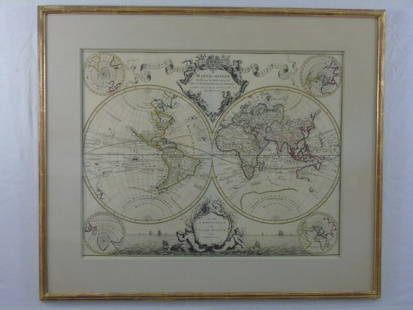
Sold2017Desnos/de la Tour: Antique Map of World in HemispheresTitle/Content of Map: 'Mappe-Monde, dressée pour l'etude de la Géographie, rélativement aux auteurs les plus modernes. Revûë, corrigée et augmentée d'apres les Nouvelles Observations AstronomiqSee Sold Price
Sold2017Chatelain: Double Hemisphere Antique World Map, 1705Map: Mappemonde ou Description General du Globe Terrestre Cartographer: Henri Chatelain Place & Date: Amsterdam / 1705 Size: 17 1/4" x 13 1/4" Condition: wash color; overall age toning, repaired splitSee Sold Price
Sold20181745 Covens and Mortier World Map -- Mappe-MondeTitle/Content of Map: 1745 Covens and Mortier World Map -- Mappe-Monde Dressee sur les Observations de Mrs. de l'Academie Royale des Sciences et Quelques Autres et sur les Memoires les Plus Recens DatSee Sold Price
20181745 Covens and Mortier World Map -- Mappe-MondeTitle/Content of Map: 1745 Covens and Mortier World Map -- Mappe-Monde Dressee sur les Observations de Mrs. de l'Academie Royale des Sciences et Quelques Autres et sur les Memoires les Plus Recens DatSee Sold Price
Sold2022World Map Mappe-Monde ou Carte Generale du GlobeTitle: World Map Mappe-Monde ou Carte Generale du Globe Terrestre Date Printed: 1678 Cartographer: Sanson, Nicholas Material/Medium: atlas map, engraved, hand colored Size: 17 x 23 Condition: The mapSee Sold Price
Sold20231651 Sanson World Map -- Mappe-Monde, ou Carte Generale du Monde; Dessignee en DeuxTitle: 1651 Sanson World Map -- Mappe-Monde, ou Carte Generale du Monde; Dessignee en Deux Plan-Hemispheres… Cartographer: N Sanson Year / Place: 1651, Paris Map Dimension (in.): 13.8 X 20.6 in.See Sold Price
2018Covens and Mortier: Antique World Map, 1745Title/Content of Map: 1745 Covens and Mortier World Map -- Mappe-Monde Dressee sur les Observations de Mrs. de l'Academie Royale des Sciences et Quelques Autres et sur les Memoires les Plus Recens DatSee Sold Price
Sold2017de la Tour: Antique Map of World; Twin Hemispheres 1777Title/Content of Map: 'Mappemonde' World twin hemispheres Date Printed: 1777 Image Size: Approx 18.5 x 16.5cm, 7.25 x 6.25 inches (Medium); Please note that this is a folding map. Type: Antique copperSee Sold Price
Sold2023Antique map of the world. Mappe-Monde. De Vaugondy, Delamarche, 1804Copperplate impression shows the finding of explorations by Cook, Perouse, Vancouver and Mackensie in 1801 and 1802. Coastlines of North America and islands of the Pacific are reasonably accurate."TerSee Sold Price
Sold2015Lg Framed early 19th c. Map of the WorldLg Framed early 19th c. Map of the World, "Mappe Monde", Indication des trois voyages du Capitaine Cook, French 1816 in floral gilt 32" x 46" frame Condition; was folded, some wear along fold lines frSee Sold Price
Sold2020Mappemonde en Deux Hemispheres Conrad Malte-Brun 1846Antique Map 'Mappemonde en Deux Hemispheres' [World Map in Two Hemispheres] by Conrad Malte-Brun (1775 - 1826) | DATE: c. 1846 | SIZE: Map with borders: Approx. 16" H x 22" W (40.64 x 55.88cm); imageSee Sold Price
Sold20171746 Homann World MapTitle: 1746 Homann World Map -- Planiglobii Terrestris Mappa Universalis utrumque Hemisphaerium Orient et Occidentale Repraesentans ex IV. Mappis Generalibus ... / Mappe-Monde qui Represente les DeuxSee Sold Price
Sold20231753 Homann World Map -- Planiglobii Terrestris Mappa Universalis utrumque Hemisphaerium Orient etTitle: 1753 Homann World Map -- Planiglobii Terrestris Mappa Universalis utrumque Hemisphaerium Orient et Occidentale Repraesentans ex IV. Mappis Generalibus … / Mappe-Monde qui Represente les DSee Sold Price
Sold2016Large Framed World Map w/ Latin InscriptionsLarge Framed World Map w/ Latin Inscriptions. Hand colored. Professionally framed and matted. Titled Mappe Monde. Measures 28 by 33 inches.See Sold Price
Sold2017A Blondeau: Mappe-Monde ou Carte Generale de la TerreMap: Mappe-Monde ou Carte Generale de la Terre, 1817 Maker: A Blondeau Date: 1817, Paris Description: An uncommon two hemisphere world map. The shown US border far exceeds into Canada north of MinnesoSee Sold Price
Sold2021de Fer, Nicolas 1717 World Map. California as Island"Mappe-Monde ou Carte Generale de la Terre" Copper Engraved Map Published 1717, Paris for "Introduction a la Geographie" by Nicolas de Fer. Folds as issued. Paper Size: 14 x 10 inch (36 x 25cm) Very mSee Sold Price
Sold2021Rare Jaeger LeCoultre Mappemonde Illuminated Deco DeskBrand: Jaeger Le Coultre Model: World Map Illuminated Table Clock Approximate Dimensions: 250mm height x 200mm diameter Base: Octagonal Marble Base MovemeSee Sold Price
Sold2021World.- Doseray (J., publisher) Mappemonde en deuxNO RESERVE World.- Doseray (J., publisher) Mappemonde en deux Hemispheres, double hemisphere world map with 5 vignettes below, heights of mountains underneath, lithograph with hand-colouring, presenteSee Sold Price
Sold2019Delamarche, Felix 1829 Map of World Hemispheres"Mappe-Monde ou Carte Generale du Globe Terrestre" Copper Engraved Map Published 1829, Paris for "Atlas de La Geographie..." by Felix Delamarche. Contemporary outline hand colour. Centre fold as publiSee Sold Price
Sold2020DANET, GUILLAUME; after DE FER, NICOLAS. Mappe-Monde ouDANET, GUILLAUME; after DE FER, NICOLAS. Mappe-Monde ou Carte Generale de la Terre. Engraved decorative double-hemispheric wall map of the world on two sheets joined with additional title-banner and bSee Sold Price
2021MAP OF THE WORLDMappe-Monde. Carte Generale du globe terrestre par F. Delamarche. 1828 framed. 32 x 47 cm.See Sold Price
Sold2023Ches. I.B. Elwe Map of the WorldFrance,1792 Map of the world by Ches. I.B. Elwe titled "Mappe Monde ou Description DU GLOBE Terrestre & Aquatique" surrounded by figures in diaphanous dresses, camels, monkeys, and other animals. ImagSee Sold Price
5 days LeftDaniels Auction GalleryAlexis Hubert-Jaillot, French, Mappe-Monde Geo-Hydrographique, 1691$500
6 days LeftA & A Auction Gallery(41)1940s-50s Army Corps World Maps - Army Map Services, Secretary of Navy, (1)Declassified$60
Apr 27Trillium Antique Prints & Rare BooksPtolemy & Magini, pub. 1620 - Double Hemisphere Map of the World$50
Apr 27Trillium Antique Prints & Rare BooksPtolemy & Magini, pub. 1620 - Map of the World with Six Windheads$50


![[maps] Chatelain, Mappe-monde: Henri Abraham Chatelain, Mappe-monde pour connoitre les progrés & le conquistes les plus Remarquables des provinces-Unies. 1708-1721. Incisione in rame. mm 335x460. Foglio: mm 445x550. Titolo in](https://p1.liveauctioneers.com/1306/122788/62497211_1_x.jpg?height=310&quality=70&version=1527839290)


![Mappemonde en Deux Hemispheres Conrad Malte-Brun 1846: Antique Map 'Mappemonde en Deux Hemispheres' [World Map in Two Hemispheres] by Conrad Malte-Brun (1775 - 1826) | DATE: c. 1846 | SIZE: Map with borders: Approx. 16" H x 22" W (40.64 x 55.88cm); image](https://p1.liveauctioneers.com/6084/186772/93903861_1_x.jpg?height=310&quality=70&version=1606446047)


![CHATELAIN, HENRI. 1684-1743. Carte De La Nouvelle France.... [Amsterdam: 1719.] (1 of 3)](https://p1.liveauctioneers.com/1043/324005/175444939_1_x.jpg?height=282&quality=70&version=1713537622)


![[Maps] American Atlas, Folio (1 of 14)](https://p1.liveauctioneers.com/3532/326332/175680379_1_x.jpg?height=282&quality=70&version=1713151485)