Sold2018Cartographer's Original Manuscript MapCartographer's Original Manuscript Map Lake Pochartrain. (Found in a bound volume of Epsy's Weather Maps ca. 1840.)x Measures 10 7/8" x 8.5". Left corner torn away. Unframed, loose and not glued or moSee Sold Price
Sold20181850 Meyer Mid-continent statesReserve Reduced! Scarce regional map of the upper Midwest from Meyer's Zeitungs-Atlas. Minnesota still labeled as Sioux Territory. Highly detailed map shows towns, rivers, lakes, roads, railroads, canSee Sold Price
Sold2016Vintage Travel Brochure - Salt Lake City, 1920Item: Graphic Old Vintage Travel Brochure; Salt Lake City Date: ca. 1920 Publisher: Salt Lake City Passenger Association Size: 4 x 9 inches Contains map, printed photos, and descriptive text about attSee Sold Price
Sold2023A Romance Map of the Finger Lakes Region of New YorkProvides numerous historical vignettes and facts about the region. Compiled by Sidney E. Hyers and Mrs Walter H Henricks CA 1937See Sold Price
Sold2020Map of Pinecrest Lodge and LakeHeading: (California - Tuolumne County) Author: Title: Pinecrest Lodge, Pinecrest, Tuolumne County, California - General Map of Pinecrest... Place Published: Modesto, CA Publisher:Belt Printing & LitSee Sold Price
Sold2018Map of the Central Division Ft. Kearney South Pass &Title/Content of Map: Map of the Central Division Ft. Kearney South Pass & Honey Lake Wagon - Road Date: 1857-1818 ca. Cartographer: WAGNER, F. W. / F. W. LANDER Size: 20.5X33.5 35th Cong. 2d. sess. SSee Sold Price
Sold2016Vintage 1948 Yellowstone Park MapThis Lot Includes a Ca. 1948 Yellowstone National Park Map Humorous pictorial map "hatched and scratched by Jolly Lindgren" featuring the highlights of a visit to the park: hotels, peaks, lakes, etc.See Sold Price
Sold2022SAM HYDE HARRIS (1889 - 1977): LAKE ARROWHEADoil on board; signed lower left; titled "Arrowhead After [obliterated]" verso; signed estate certification verso; 12 x 16 inches; 17 x 21 1/4 inches frameSee Sold Price
Sold2019Lake Arrowhead Lake Shore Cottages SignSST. Measures: 34.75"X58.5" Rating: 7.75 Est: $350-$700See Sold Price
Sold2022(MISCELLANEOUS MAPS.) Group of 18 double-page or folding engraved European regional maps.(MISCELLANEOUS MAPS.) Group of 18 double-page or folding engraved European regional maps. Folio sheets; European makers. 17th-18th centuries - Eugene Henry Fricx. Les Costes du Boulenois, et le pas deSee Sold Price
Sold2015Jansson (Jan) - [Atlas Novus: Germany],single vol. lacking title, 106 mostly regional maps of Germany and northern Europe, but also including a general map of Germany, and classical maps of both Germany and Scandinavia, and several city plSee Sold Price
Sold2023Dine [Navajo], Historic Regional Rug, ca. 1900 - 1910Dine [Navajo] Historic Regional Rug, ca. 1900 - 1910handspun native sheep wool, aniline dyes(design pattened after Navajo wearing blanket)77 x 59 1/4 in. (195.6 x 150.5 cm.) Private Collection, ArizonSee Sold Price
Sold2024Frederick F. Schafer, "Indian By the Lake, Lake Tahoe", ca. 1880-1900Frederick Ferdinand Schafer (California / Germany, 1839-1927), "Indian By the Lake; Lake Tahoe", ca. 1880-1900, oil on canvas, appraisal from 2006 included sight: 30 x 20 in., frame: 33 x 23.See Sold Price
Sold2015S. Farmer's 1872 Pocket Map of Lake SuperiorFull title being: Farmer's Map of Lake Superior and the Mining Regions, showing Geological Formations, Mines, Mining Lands, Lakes, Marshes, Hills, Roads, Rail Roads, Towns, and Villages with historicaSee Sold Price
Sold2023 [MAPS - GREAT LAKES REGION]. VAUGONDY, Gilles Robert de (16...[MAPS - GREAT LAKES REGION]. VAUGONDY, Gilles Robert de (1688-1766). Les Lacs du Canada et Nouvelle Angleterre… Paris, 1749. Engraved map (229 x 318 mm) with hand-colored outlining, appearing toSee Sold Price
Sold2021North American Great Lakes Copper ArrowheadEarly North American Great Lakes region copper arrowhead or point. Keywords: Prehistoric, Pre-Columbian. Length: 5 in x width: 1 1/2 in x depth: 1/4 in.See Sold Price
Sold2015L.P. LATIMER, California Landscape Art Watercolor.LORENZO PALMER LATIMER (California 1857-1941) "Scene at the Old Wise Camp-Lake County CA" Watercolor. Sight: 10 1/4 x 13 5/8 inches; Framed: 17 1/8 x 20 1/8 inches. Signed and dated "1940" l/l. AnnotaSee Sold Price
Sold202219th C. PNG Sepik River Wood Mask - Barak SpiritOceania, Papua New Guinea, lower Sepik River, Murik Lakes region, ca. 19th to early 20th century CE. This is an extraordinary wooden mask with a lengthy nose that resembles a mosquito! The mask is comSee Sold Price
2023Huge 20th C. PNG Sepik River Gugumbe / Fireplace Bowl**Originally Listed At $500** Oceania, Papua New Guinea, Sepik River region, Chambri Lakes, Aibom, ca. early 20th century CE. This is a massive pottery fireplace bowl or gugumbe, with an ancestral facSee Sold Price
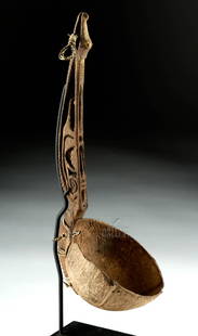
Sold2020Early 20th C. Papua New Guinea Wood & Coconut Ladle**Originally Listed At $250** Oceania, Papua New Guinea, Murik Lakes region, ca. early to mid-20th century CE. A coconut half-shell ladle or dipper with a hand-carved wooden handle. The handle is attaSee Sold Price
Sold2023IIMPORTANT 18TH C. REVOLUTIONARY WAR PERIOD MAP: SURVEY OF LAKE CHAMPLAIN, 1776IMPORTANT 18TH C. REVOLUTIONARY WAR PERIOD MAP: SURVEY OF LAKE CHAMPLAIN, 1776, SURVEY OF LAKE CHAMPLAIN INCLUDING LAKE GEORGE , CROWN POINT, AND ST. JOHN. SURVEYED, BY ORDER OF HIS EXCELLENCY MAJOR-GSee Sold Price
Sold2020Willem Blaeu Map of Guinea ca. 1631Willem Janszoon Blaeu (1571-1638), "Guinea," Amsterdam, ca. 1631. A hand colored map of the Gulf of Guinea region of Africa, including what is now Guinea, Sierra Leone, Liberia, Cote d'Ivoire, Ghana,See Sold Price
Sold2016Influential map of Great Lakes region 1755Heading: Author: Bellin, Jacques Nicolas Title: Partie Occidentale de la Nouvelle France ou du Canada Place Published: Nuremberg Publisher:Homann Heirs Date Published: 1755 DescriptionSee Sold Price
Sold2017Cary: US Western Territory/Great Lakes Region Map, 1805Map: A New Map of Part of the United States of North America, exhibiting the Western Territory, Kentucky, Pennsylvania, Maryland, Virginia &c., also the lakes Superior, Michigan, Huron, Ontario & ErieSee Sold Price
4 days LeftJasper521867 Beers Map of Ossining with Sing Sing Prison in New York -- Sing Sing, The Town of Ossining,$80
BonhamsSEUTTER, MATTHÄUS. 1678-1757. And TOBIAS CONRAD LOTTER. 1717-1777. Recens edita totius Novi...$900(1 bid)
4 days LeftJasper521867 Beers Map of Parts of Weschester Co., New York In cluding Tarrytown -- Plan of Beekmantown,$80
May 05Tremont AuctionsJohn Speed and Francis Lamb "Map of New England and New York", ca. 1676. Hand colored engraved map$500(1 bid)
4 days LeftJasper521893 Civil War Map of the Ohio Valley including Kentucky, Ohio, Indiana and Illinois -- General$55
May 16Potter & Potter AuctionsLINDGREN, Hjalmer “Jolly” (1895–1952). A Hysterical Map of ...$200


![SAM HYDE HARRIS (1889 - 1977): LAKE ARROWHEAD: oil on board; signed lower left; titled "Arrowhead After [obliterated]" verso; signed estate certification verso; 12 x 16 inches; 17 x 21 1/4 inches frame](https://p1.liveauctioneers.com/1285/241388/125138945_1_x.jpg?height=310&quality=70&version=1647644786)


![Jansson (Jan) - [Atlas Novus: Germany],: single vol. lacking title, 106 mostly regional maps of Germany and northern Europe, but also including a general map of Germany, and classical maps of both Germany and Scandinavia, and several city pl](https://p1.liveauctioneers.com/410/80717/41962763_1_x.jpg?height=310&quality=70&version=1445353131)
![Dine [Navajo], Historic Regional Rug, ca. 1900 - 1910: Dine [Navajo] Historic Regional Rug, ca. 1900 - 1910handspun native sheep wool, aniline dyes(design pattened after Navajo wearing blanket)77 x 59 1/4 in. (195.6 x 150.5 cm.) Private Collection, Arizon](https://p1.liveauctioneers.com/317/277373/145695125_1_x.jpg?height=310&quality=70&version=1675190564)


![[MAPS - GREAT LAKES REGION]. VAUGONDY, Gilles Robert de (16...: [MAPS - GREAT LAKES REGION]. VAUGONDY, Gilles Robert de (1688-1766). Les Lacs du Canada et Nouvelle Angleterre… Paris, 1749. Engraved map (229 x 318 mm) with hand-colored outlining, appearing to](https://p1.liveauctioneers.com/928/301544/160920958_1_x.jpg?height=310&quality=70&version=1694462960)