Sold2021(D No. 3) Preliminary chart of the Entrances to CapePublication Date: 1854 Title: (D No. 3) Preliminary chart of the Entrances to Cape Fear River and New Inlet North Carolina Cartographer: C.P. Bolles Publisher: U.S. Coast Survey / Robert Armstrong HeiSee Sold Price
Sold2021Three South Carolina MapsPreliminary Chart of Port Royal Entrance, Beaufort Chechessee and Colleton Rivers... U.S. Coast Survey Office, Superintendent A. D. Bache, triangulation by C. O. Boutelle... 1859, single sheet, engravSee Sold Price
Sold2018Preliminary Chart of Entrance to San Francisco BayTitle: Preliminary Chart of Entrance to San Francisco Bay California Publication Date: 1856 Cartographer: CUTTS, R. D./A. F. RODGERS Publisher: U.S.C.S. Size: 14.25X17.1 "From a trigonometrical surveySee Sold Price
Sold2022FULLER, CAPTAIN WILLIAM; JEFFERYS, THOMAS; and DE BRAHM, WILLIAM GERARD Plan of Amelia Island inFULLER, CAPTAIN WILLIAM; JEFFERYS, THOMAS; and DE BRAHM, WILLIAM GERARD Plan of Amelia Island in East Florida [and] A Chart of the Entrance into St. Mary's River...[and] A Chart of the Mouth of NassauSee Sold Price
Sold2021(D. No.3) Preliminary Chart of lower part of Cape FearPublication Date: 1855 Title: (D. No.3) Preliminary Chart of lower part of Cape Fear River North Carolina Cartographer: C.P. Bolles Publisher: U.S. Coast Survey Height: 30.5 Width: 25.5 From a trigonoSee Sold Price
Sold2018Antique 1856 US Coastal Survey of Martha's VineyardTitle/Content of Map: 1856 US Coastal Survey of Martha's Vineyard amd Nantucket Area in Massachusetts -- Preliminary Chart of Part of the Sea Coast of Massachusetts from Saughkonnet River to PlymouthSee Sold Price
Sold2021Preliminary Chart of Nantucket Shoals together withPreliminary Chart of Nantucket Shoals together with Tidal Currents of Nantucket Shoals, 1854, Chart in a molded Bird's Eye Maple, Tidal Currents matted and framed 18.25 in. x 19.5 in. Overall 24 in. xSee Sold Price
Sold2021Preliminary Chart of Nantucket Shoals"Preliminary Chart of Nantucket Shoals", from a trigonometrical survey under the direction of A.D. Bache Superintendent of the Survey of the coast of the United States, 1864 23.5 in. x 19.5 in. FramedSee Sold Price
Sold2018Preliminary Chart of St. Augustine Harbor FloridaMap: Preliminary Chart of St. Augustine Harbor Florida Publication Date: 1862 Publisher: U.S. C.S. Size (inches): 20.25X21.25 Attractive detailed chart with soundings and sailing directions. Shows towSee Sold Price
Sold2020Preliminary Chart of St. Augustine Harbor FloridaTitle/Content of Map: Preliminary Chart of St. Augustine Harbor Florida Cartographer: F. W. Dorr Date: 1879 Publisher: U.S. C.S. Size: 21”Height - 21.75”Width Railroad ends at west bank ofSee Sold Price
Sold2020(Sketch F, No.5) Preliminary Chart of Key West HarborTitle/Content of Map: (Sketch F, No.5) Preliminary Chart of Key West Harbor and Approaches... 1851 Publication Date: 1851 Cartographer: KNORR, E. K./ISSAC HULL ADAMS Publisher: U.S. COAST SURVEY DescrSee Sold Price
Sold2020Preliminary Chart of Monterey Bay CaliforniaTitle/Content of Map: Preliminary Chart of Monterey Bay California Date: 1857 Cartographer: HARRISON, A. M. Publisher: U.S.C.S. Size: 30.75Height - 20.5Width From a trigonometrical survey ... triangulSee Sold Price
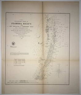
Sold2020(F No.4) Preliminary Chart of Florida Reefs from KeyTitle/Content of Map: (F No.4) Preliminary Chart of Florida Reefs from Key Biscayne to Carysfort Reef... Publication Date: 1855 Cartographer: Totten, Jas./I. Hull Adams Publisher: U.S. Coast Survey DeSee Sold Price
Sold2021(A. No.3) Preliminary Chart of Ipswich and AnnisquamPublication Date: 1855 Title: (A. No.3) Preliminary Chart of Ipswich and Annisquam Harbors Cartographer: WHITING, H. L. Publisher: U.S.C.S. Height: 19 Width: 28.6 Massachusetts. Reduced drawing by J.RSee Sold Price
Sold2021Antique Coast Survey Map of the Atchafalaya BayAntique Coast Survey Map of the Atchafalaya Bay , "Preliminary Chart of Atchafalaya Bay Louisiana... A.D. Bache, Superintendant", 1858, lithograph, with later hand-coloring, sight 24 1/2 in. x 31 1/4See Sold Price
Sold2022Martha’s Vineyard, 1855 Coastal SurveyPainstakingly hand-colored large chart showing Martha’s Vineyard and the Falmouth area of Cape Cod. Minutely detailed with hundreds of soundings shown. “Preliminary Chart of Muskeget ChannSee Sold Price
Sold20201858 US Coast Survey Map of Charleston Harbor --Title/Content of Map: 1858 US Coast Survey Map of Charleston Harbor -- Preliminary Chart of Charleston Harbor and Its Approaches from a Trigonometrical Survey Under the Direction of A.D. Bache… CartSee Sold Price
Sold20191858 Chart Map of Charleston Harbor"Preliminary Chart of Charleston Harbor And Its Approaches From a Trigonometric Survey . . . Triangulation by C.O. Boutelle . . . Topography by S.A. Gilbert & J. Seib . . . Hydrography by the PartiesSee Sold Price
Sold2018U.S Coast Survey 1853 Map. Gargathy Machipongo Inlet VA"Preliminary Chart of the Sea Coast of Virginia From Gagathy Inlet to Gr. Machipongo Inlet" Electrotype Map Published 1843-65, Washington for "Report of the Superintendent of the U.S. Coast Survey..."See Sold Price
Sold2018U.S Coast Survey 1853 Map. Ship Island Shoal, Louisiana"Preliminary Chart of Ship Island Shoal Louisiana" Electrotype Map Published 1843-65, Washington for "Report of the Superintendent of the U.S. Coast Survey..." Published under the supervision and direSee Sold Price
Sold2023U S Coast Survey 1856 Large Map. St. Mary's Bar & Fernandina Harbor Florida"Preliminary Chart of St. Mary's Bar and Fernandina Harbor Florida"Large Lithograph Map Published 1857, Washington for "U.S. Coast and Geodetic Survey" Folds as issued. Paper Size: 25 x 23 inch (64 xSee Sold Price
Sold2018Collection of Old Postcards,album and loose, includes Panama Canal, WWI, ships, real photo, holiday, lots of Florida (mostly St.John's River and St.Augustine area), mostly 1900-1910's, few linen, over 400.See Sold Price
Sold2022Ringgold chart of entrance to S.F. Bay 1850Heading: (California - San Francisco) Author: Title: Chart of the Farallones and Entrance to the Bay of San Francisco California Place Published: [Washington] Publisher:[Printed by Jno. T. Towers]See Sold Price
Sold2020Encyclo. Britannica C1830 Mountain & River ChartCopper Engraved Map Published 1830-42, Edinburgh for "Encyclopedia Britannica" Seventh Edition. Centre fold as issued. Paper Size: 16 x 11 inch (40 x 28cm) Some toning, otherwise fineSee Sold Price
May 16Zikorn Arts & History ObjectsEntrance to Baltic Great & Little Belt 1852 British Admiralty Map$100
May 05Churchill GalleriesChart: United States- East Coast/ NORTH CAROLINA/ RIVER INLET TO CAPE FEAR.$10
5 days LeftJasper52North America Gulf of St. Lawrence Entrance. St. Johns (Newfoundland) to Halifax (Nova Scotia) With$260
May 05Churchill GalleriesCHART: UNITED STATES - EAST COAST NEW YORK/ HUDSON RIVER/ POUGHKEEPSIE TO HUDSON$10
5 days LeftJasper52Reconnoissance of the Western Coast of the United States from Monterey Bay to The Columbia River in$240
5 days LeftJasper521850 Sacramento and San Joaquin Rivers Chart -- Chart of Suisun & Vallejo Bays with the Confluence$200
4 days LeftClaydon Auctioneers LtdThree mid 20thC Hydrographic Office maritime navigational charts for Wales - South Coast, comprising£20


![FULLER, CAPTAIN WILLIAM; JEFFERYS, THOMAS; and DE BRAHM, WILLIAM GERARD Plan of Amelia Island in: FULLER, CAPTAIN WILLIAM; JEFFERYS, THOMAS; and DE BRAHM, WILLIAM GERARD Plan of Amelia Island in East Florida [and] A Chart of the Entrance into St. Mary's River...[and] A Chart of the Mouth of Nassau](https://p1.liveauctioneers.com/292/250642/130213561_1_x.jpg?height=310&quality=70&version=1654271664)


![Ringgold chart of entrance to S.F. Bay 1850: Heading: (California - San Francisco) Author: Title: Chart of the Farallones and Entrance to the Bay of San Francisco California Place Published: [Washington] Publisher:[Printed by Jno. T. Towers]](https://p1.liveauctioneers.com/642/270500/141583081_1_x.jpg?height=310&quality=70&version=1670438782)


![Mississippi River. Sheet No.2 [Columbus, Ky. to Island No.9] (1 of 12)](https://p1.liveauctioneers.com/5584/326512/175785588_1_x.jpg?height=282&quality=70&version=1713903186)


