Sold20211829 BURR MAP ORANGE & ROCKLAND COUNTYHand-colored engraving. Dimensions: (Frame) H 26.75" x W 29.75", (Sight) H 18" x W 21.25" Condition: Map with center fold as published. Scattered staining and light foxing. Frame with marks.See Sold Price
Sold20223 David Burr Maps Erie & Niagara County3 David Burr Maps Erie & Niagara County Framed - approx 25" x 21.5"See Sold Price
Sold20171829 David Burr Clinton County, NY map1829 David Burr Clinton County, NY map, Rawdon Clark & Co., Albany & Rawdon Wright & Co., NY hand colored, earliest known printed map of Clinton County, plate size 17 3/4" x 20", sheet size 24" x 21 1See Sold Price
Sold2023Map: Antique Town of Center Moriches, Suffolk County, LONG ISLAND NYDescription: Map: Antique Town of Center Moriches, Suffolk County, LONG ISLAND NYMeasurement approximate: Frame 38 x 27 InchesMaterial: PaperSee Sold Price
Sold2016Town of Southampton Map (North Haven & Art Village),Original engraving of Southhampton town, including Peconic Bay, Hobson Island and many landmarks & family names. Published by E. Belcher Hyde from "Atlas of Suffolk County, Long Island, New York," 190See Sold Price
Sold2023E. Belcher Hyde Map Co. - Maps of Suffolk, Group of 4Lot 49 E. Belcher Hyde Map Co. American Manufacturer (fl. c. 1880 - 1920) Maps of Suffolk, Group of 4 (1916) lithograph with hand coloring from Suffolk County 1916 Vol 2 Long Island, New York, includeSee Sold Price
Sold20211829 County Map of Rensselaer County NY by David H BurrMap of the County of Rensselaer from 1829, by David H Burr. Rensselaer County sits on the bank of the Hudson River and was founded in 1791. Wooden frame with gold border. Great local map. DimensionsSee Sold Price
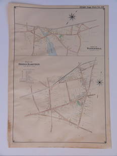
Sold2023E. Belcher Hyde Map Co. - Maps of Sag Harbor, Group of 2Lot 48 E. Belcher Hyde Map Co. American Manufacturer (fl. c. 1880 - 1920) Maps of Sag Harbor, Group of 2 (1916) lithograph with hand coloring from Suffolk County 1916 Vol 2 Long Island, New York 17 xSee Sold Price
Sold2022Dugdale & Archer C1840 Lot of 7 English County MapsIncl Worcestershire, Wiltshire, Westmoreland, Warwickshire, Sussex, Surrey, and Suffolk. Steel Engraved Maps with outline hand color Published C1835-60 London for "Curiosities of Great Britain. EnglanSee Sold Price
Sold2019British County Maps 19th Cent Lot of 6Lot of 6 Steel Engraved Maps. Incl Caermarthenshire, Suffolk, Lincoln, Leicestershire, Lancashire, and Cornwall. Mostly by Dugdale/Archer also Fisher/Davies, probably from Barcaly's Dictionary. PaperSee Sold Price
Sold2016Bridgehampton & Watermill, Long Island, 1902Original engraving published by E. Belcher Hyde from "Atlas of Suffolk County, Long Island, New York," Philadelphia, 1902. Map features family names, historic buildings and railroad routes. DimensionsSee Sold Price
Sold20211839 MAP OF ULSTER COUNTY, NEW YORK, BY DAVID H. BURR,1839 MAP OF ULSTER COUNTY, NEW YORK, BY DAVID H. BURR, STONE & CLARK PUBLISHERS, ITHICA, N.Y. NICELY FRAMED, FROM PROMINENT ELLENVILLE, N.Y. ATTORNEYS OFFICE. MAP MEASURES 22" X 23", NICELY FRAMED, ANSee Sold Price
Sold2023Early Wall Map of Dutchess Putnam New York, David Burr 1839Early Wall Map of Dutchessand Putnam County New York, David Burr 1839. Antique map in scroll format with thick dark painted wood supports features cities of the period including Poughkeepsie, RhinebecSee Sold Price
Sold2021(NEW YORK.) David H. Burr. Hudson River & Vicinity.(NEW YORK.) David H. Burr. Hudson River & Vicinity. Engraved strip map of the Hudson River from lower Warren County to New York City. 24¾x4½ inches extended, folding into publisher's 12mo foSee Sold Price
Sold2016America.- Burr (David H.) - An Atlas of the State ofContaining a Map of the State and of the Several Counties, [third edition], engraved title, 51 hand-coloured engraved maps and plans on 52 sheets as issued, including double-page and folding, some foxSee Sold Price
Sold2024BURR, David A. (1803-1875). Ohio. New York City, New York, 1831.BURR, David A. (1803-1875). Ohio. New York City, New York, 1831. Engraved map of the state of Ohio, visible area 10 1/8 x 12 1/2 inches. Showing counties, towns, and cities, with accurate road systemsSee Sold Price
Sold2016Burr Map of Queens, Kings & Richmond.Map of Queens, Kings & Richmond. David H. Burr (1803-1875). Engraving with original hand color. Ithaca, NY: Stone Clark, 1839. 17 1/4 x 22 1/4 inches sheet, 22 x 27 inches framed. This map from The AtSee Sold Price
Sold20191835 Burr Map of Evolving Cartography of the GreatReserve Reduced! Map Title/Content: 1835 Burr Map of Evolving Cartography of the Great Lakes -- A Map, Exhibiting the Relative Positions of Lake Erie & Michigan According to Recent Surveys [on sheet wSee Sold Price
Sold2023Burr - Map of North AmericaThis hand-colored map is from David H. Burr's A New Universal Atlas; comprising separate maps of all the principal empires, kingdoms & states throughout the world: and forming a distinct atlas of theSee Sold Price
Sold2017Burr: Map of Illinois & Wisconsin, 1836Map: 1836 Burr Map of Illinois and Wisconsin -- Map of Illinois with parts of Indiana, Ouisconsin, & C, by David H. Burr, Draughtsman to the House of Reps. U.S. 1836 Cartographer: D Burr Year / Place:See Sold Price
Sold2016Antique Map, County of Southampton, Greenwood & Co.Greenwood & Co. (British, 19th century), "Map of the county of Southampton from an Actual Survey, made in the years 1825 & 1826," hand-colored copper-engraved map, engraved by J. and J. Neele, publishSee Sold Price
Sold2023An 1860 Map, Counties of New York, New Hampshire, Etc...Hand colored lithograph, by Samuel Augustus Mitchell (1790-1868). :County Map of the States of New York, New Hampshire, Vermont, Massachusetts, Rhode Island and Connecticut". Dimensions:15 1/2" x 23 1See Sold Price
Sold2023Antique Map County of Cumberland EnglandAntique Framed and Hand Colored Map of the County of Cumberland, England by Richard Blome (London Engraver 1600-1705) . 16 inches x 13 inchesSee Sold Price
Sold2023Antique Map County of Northumberland EnglandAntique Framed and Hand Colored Map of the County of Northumberland, England by Richard Blome (London Engraver 1600-1705) . 16 inches x 13 inchesSee Sold Price
5 days LeftJasper52New Map of That Portion of North America Exhibiting the United States and Territories...Mexico...$360
May 16Potter & Potter AuctionsMcCARTY, Lea (1905 – 1960). Sonoma County / Its Highlights ...$100(1 bid)


![America.- Burr (David H.) - An Atlas of the State of: Containing a Map of the State and of the Several Counties, [third edition], engraved title, 51 hand-coloured engraved maps and plans on 52 sheets as issued, including double-page and folding, some fox](https://p1.liveauctioneers.com/410/84263/43496522_1_x.jpg?height=310&quality=70&version=1453293226)


