Sold2017Sartine Map of FloridaCarte Réduite des Cotes et de l’Interieur de la Presqu’ile de la Floride. Antoine Sartine (1729-1801).Engraved map. Paris, 1780. 24 x 17 inches visible, 37 x 29 inches framed. This well engravedSee Sold Price
Sold2021Antique map, Canada, Greenland, "Carte Du Canada ou deAntique map, Canada, Greenland, "Carte Du Canada ou de la Nouvelle France et des Decouvertes qui y ont été faites Dressée sur plusieurs Observations et sur un grannombres de Relations iSee Sold Price
Sold2022MAP, Canada & Greenland, MortierNorthern Canada, Greenland & Iceland. Pierre Mortier, Carte Particuliere de l'Amerique Septentrionale, ou sont Compris le Destroit de Davids, le Destroit de Hudson, &c. Dresse sur les Relations les PlSee Sold Price
Sold2023MAP, Canada, CruttwellEastern Canada. Clement Cruttwell, British America, Comprehending Canada, Labrador, New-Foundland, Nova Scotia &c:, from Atlas to Cruttwell's Gazetteer, 1808 (dated). Hand Color. This scarce map of CaSee Sold Price
Sold20201872 1ed NIAGARA Falls River Geology MAP Canada Indians1872 1ed NIAGARA Falls River Geology MAP Canada Indians Toronto Ontario Erie George Holley’s ‘Niagara’ is a rare 19th-century account of famous waterfall and river in America’s Northeast. ThisSee Sold Price
Sold2021Guthrie, William 1798 Map. Canada North America"British Colonies in North America from the best Authorities" Copper Engraved Map Published 1798, London for "A New Geographical, Historical and Commercial Grammar..." by William Guthrie. The maps areSee Sold Price
Sold2016Geographical, Statistical & Historical Map Canada, 1823Map: Geographical, Statistical and Historical Map of Upper and Lower Canada, and the other British Possessions in North America Cartographer: F. Lucas Publishing: Philadelphia / Baltimore, 1823 Size:See Sold Price
Sold20211867 Map Canada / British America by Michaud"Part of British America". Depicting Canada from British Columbia east to Newfoundland. C. E. Michaud lower right corner. Very good condition; normal age toning, etc. Folds as issured. 9.75" x 35.25"See Sold Price
Sold20201757 Engraved Map Canada AcadiaCarte De L'Acadie Isle Royale, by Jacques-Nicholas Bellin printed 1757 showing the Canadian including Chebucto and Halifax. Printed for his work "L'Histoire Generale des Voyages" at Paris. Fine. MeasuSee Sold Price
Sold2021Findlay, Alex C1835 Antique Map. CanadaSteel Engraved Map Published C1835 by Thomas Kelly, London for "A New and Universal English Dictionary" by the Rev. James Barclay. Maps Drawn & Engraved by Alexander Findlay. Paper Size: 10.5 x 8 inchSee Sold Price
Sold2023Russell & Barclay 1832 Hand Col Map. Canada. British Dominions in North AmericaHand Colored Steel Engraved Map Published 1823-40, by Fisher & Son, "A Complete Atlas of the World" by John Russell et al. A Very Rare Work which is compiled from the same plates used in different ediSee Sold Price
Sold2018Colton: Antique Map Canada, Russian Alaska & GreenlandTitle/Content of Map: Canada, Russian Alaska & Greenland Date Printed: 1859 Cartographer: H.J. Colton Material/Medium: Paper Size: 17 1/2" x 15" Hand colored, engraved Map. Published in New York in CoSee Sold Price
Sold2023Thomson, John (Pub) 1825 Map. CanadaCopper Engraved Map Published 1825 by John Thomson, Edinburgh for "The Edinburgh School Atlas" by N. R. Hewitt. Maps Engraved by Hewitt. Original Outline Hand Colour. Rare. Paper Size: 10.5 x 8 inch (See Sold Price
Sold2023Becker, F. P. C1845 Antique Map. CanadaSteel Engraved Map Published C1845, London for "A Complete and Universal English Dictionary" by the Rev. James Barclay and B. B. Woodward. Maps by F. P. Becker. Outline hand color. Paper Size: 11 x 8See Sold Price
Sold2022Barclay & Becker C1845 Map. CanadaSteel Engraved Map Published C1845, London for "A Complete and Universal English Dictionary" by the Rev. James Barclay and B. B. Woodward. Maps by F. P. Becker. Outline hand colour. Paper Size: 10.5 xSee Sold Price
Sold2022Times Atlas 1895 Pair of Maps. Canada - East & WestLithograph Map Published 1895, London for "The Times Atlas" Two with Centre fold as published. Up to Paper Size: 16 x 10 inch (41 x 26cm) Good ConditionSee Sold Price
Sold2020Becker, F. C1838 Antique Map. CanadaSteel Engraved Map with outline hand color Published C1838, London for "A Complete and Universal English Dictionary" by the Rev. James Barclay et al. Maps by F. Becker and others. Paper Size: 10.5 x 8See Sold Price
Sold2019Gross, Alexander 1920 Lot of 6 Large Maps. CanadaLarge Lithograph Maps Published 1920, London for "The Daily Telegraph Victory Atlas of the World" by Alexander Gross. Centre fold as published. Paper Size: 25 x 19.5 inch (64 x 49cm) Good ConditionSee Sold Price
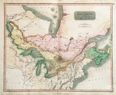
Sold2018Thomson: Antique Map of Canada & Nova Scotia, 1817Title/Content of Map: Canada and Nova Scotia. Date Printed: 1817 Cartographer: THOMSON, JOHN & CO. Size (inches): 16.1x22 No.43 (unnumbered) from Thomson's New General Atlas 1817. W. Dassauville engr.See Sold Price
Sold2019N AMERICA E COAST Canada Virginia New Amsterdam (NewTITLE OF THE MAP: 'Canada ou Nouvelle France' Small vignette. The map runs inland to Lake Superior. Includes Bermuda. DATE PRINTED: 1683 IMAGE SIZE: Approx Overall page size 13 x 21cm approximately (5See Sold Price
Sold2018N AMERICA E COAST Canada Virginia New Amsterdam (NewTITLE OF THE MAP: 'Canada ou Nouvelle France' Small vignette. The map runs inland to Lake Superior. Includes Bermuda. Date: 1683 IMAGE SIZE: Approx Overall page size 13 x 21cm approximately (5 x 8 incSee Sold Price
Sold2018Thomson: Antique Map of Canada & Nova Scotia, 1814Map: Canada and Nova Scotia Cartographer: Thomson Place & Date: Edinburgh / 1814/1817 Size: 23 3/4" x 19 1/8" Condition: wash color; light browning and minor staining in margins The superbly detailedSee Sold Price
Sold2018Thomson: Upper & Lower Canada, Nova ScotiaMap: Canada and Nova Scotia Cartographer: Thomson Place/Date: Edinburgh / 1814/1817 Size: 23 3/4" x 19 1/8" Condition: wash color; light browning along centerfold and in margins; some staining in uppeSee Sold Price
Sold2017Bellin: Antique Map of Canada's St Laurence River, 1740Title/Content of Map: Canada's St. Laurence river region by Bellin Date Printed: c 1740-70's Cartographer: J.N. Bellin & J.F. La Harpe Material/Medium: Paper Size: 14" x10" Copperplate engraved. PubliSee Sold Price
May 05Tremont Auctions1778 "Il Canada" original map depicting Canada and the US. Hand colored. Fold down center. Framed.$150
341 Lots AwayJasper52A Plan of the Harbour of Chebucto & Town of Halifax. Canada. GENTS MAG 1750 map$500
3 days LeftNadeau's Auction GalleryMap of the Northwest Port of Canada, Indian Territories Hudson's Bay$150
3 days LeftRenew GalleryCirca 1815 Engraved Map A Plan of the Grand of the New Townships on the Grand or Ottawa River$100
May 09Hunt and Peck Estate Services, Inc.Jacques Nicolas Bellin Map Of Western Part Of New France Or Canada$200(1 bid)
May 09Hunt and Peck Estate Services, Inc.1794 Laurie & Whittle after Thomas Jefferys Map Of The United States Of America$340(1 bid)
228 Lots AwayJasper52Large Civil War map of the United States. ETTLING. Illustrated London News 1861$280
May 10Rail & Road AuctionsThree Canadian Pacific Airlines Advertising Lighters - Zenith, Madison, and Coronet$20(1 bid)
May 10Rail & Road AuctionsThree Canadian Pacific Airlines and Canadair Limited Advertising Lighters - Polar Bear, Golden Bell,$30(1 bid)
May 10Rail & Road AuctionsFive Trans-Canada Air Lines and Mid-Continent Airlines Timetables and Brochure$20