Sold20211842 Map of GreeceAuthor: Scott Title: 1842 Map of Greece Medium: Ink on Paper Dimensions: 11.5"X9" Map of Greece dated 1842. Engraved by R. Scott. Part of the New General Atlas of the World. Copper plate engraving. PuSee Sold Price
Sold2023MAP, Greece, Cantelli da VignolaNorthern Greece, Albania, & Macedonia. Cantelli da Vignola/de Rossi, Macedonia Epiro Livadia Albania e Ianna..., from Mercurio Geografico..., 1684 (dated). Hand Color. This handsome Italian map of norSee Sold Price
Sold2024West India Islands. Caribbean. La Salle settlement in Texas. LIZARS 1842 mapTITLE/CONTENT OF MAP: 'West India Islands and adjacent coasts of the United States, Mexico, Guatimala & Colombia' The map notes anecdotally the location of René Robert Cavelier, Sieur de La SalleSee Sold Price
Sold2023South America /Atlantic Ocean. Gran Colombia. United Provinces. LIZARS 1842 mapTitle: South America /Atlantic Ocean. Gran Colombia. United Provinces. LIZARS 1842 map Description: South America' by William Home Lizars (1842). Antique 19th century atlas map with original hand coloSee Sold Price
Sold20201842 map of New York City, Sidney MorseFrom the very first cerographic atlas ever published. Two tiny very lightly discolored areas at top edge; corner crease. 12 x 15. Reserve: $90.00 Shipping: Domestic: Flat-rate of $6.00 to anywhere witSee Sold Price
Sold20201842 Map of North AmericaAuthor: Scott Title: 1842 Map of North America Medium: Ink on Paper Dimensions: 9"X11.5" Map of North America dated 1842. Engraved by R. Scott. Part of the New General Atlas of the World. Published bySee Sold Price
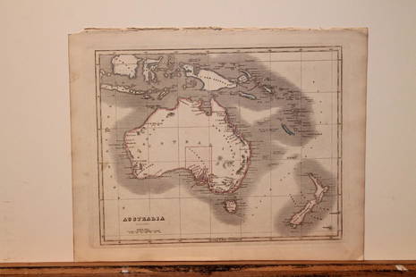
20201842 Map of AustraliaAuthor: Scott Title: 1842 Map of Australia Medium: Ink on Paper Dimensions: 11.5X9" Description: Map of Australia dated 1842. Copper plate map. Engraved by R. Scott. Published by Thomas Nelson in EdinSee Sold Price
Sold20201842 Map of AsiaAuthor: Scott Title: 1842 Map of Asia Medium: Ink on Paper Dimensions: 11.5"X 9" Description: Map of Asia dated 1842. Copper plate map. Engraved by R. Scott. Published by Thomas Nelson in Edinburgh. PSee Sold Price
Sold20201842 Map of AustraliaAuthor: Scott Title: 1842 Map of Australia Medium: Ink on Paper Dimensions: 11.5"X9" Map of Australia dated 1842. Copper plate map. Engraved by R. Scott. Published by Thomas Nelson in Edinburgh. PartSee Sold Price
Sold20201842 Map of AfricaAuthor: Scott Title: 1842 Map of Africa Medium: Ink on Paper Dimensions: 11.5 X 9" Description: Map of Africa dated 1842. Copper plate map. Engraved by R. Scott. Published by Thomas Nelson in EdinburgSee Sold Price
Sold20201842 Map of North AmericaTitle: 1842 Map of North America Author: Nelson Medium: Ink on Paper Dimensions: 9"X11.5" Description: Map of North America dated 1842. Engraved by R. Scott. Part of the New General Atlas of the WorldSee Sold Price
Sold20201842 Map of ChinaAuthor: Scott Title: 1842 Map of China Medium: Ink on Paper Dimensions: 9"X11.5" Description: Map of China dated 1842. Copper plate map. Engraved by R. Scott. Published by Thomas Nelson in Edinburgh.See Sold Price
Sold20211842 Map of FranceAuthor: Scott Title: 1842 Map of France Medium: Ink on Paper Dimensions: 11.5"X9" Map of France engraved by R. Scott dated 1842. Part of the New General Atlas of the World. Published by Thomas NelsonSee Sold Price
Sold20211842 Map of the East IndiesAuthor: Scott Title: 1842 Map of the East Indies Medium: Ink on Paper Dimensions: 11.5"X9" Map of the East Indies dated 1842. Engraved by R. Scott. Part of the New General Atlas of the World. Copper pSee Sold Price
Sold2022Canada 1842 Map by W. Hughes/BartlettSteel Engravinged Map Published 1842 by George Virtue, London for "Canadian Scenery Illustrated..." by Nathaniel P. Willis. Illustrated by William H. Bartlett. Map drawn and engraved by William HughesSee Sold Price
Sold20211842 Map of SwitzerlandAuthor: Scott Title: 1842 Map of Switzerland Medium: Ink on Paper Dimensions: 11.5"X9" Map of Switzerland engraved by R. Scott dated 1842. Part of the New General Atlas of the World. Published by ThomSee Sold Price
Sold20211842 Map of RussiaAuthor: Scott Title: 1842 Map of Russia Medium: Ink on Paper Dimensions: 9"X11.5" Map of Russia in Europe dated 1842. Engraved by R. Scott. Part of the New General Atlas of the World. Copper plate engSee Sold Price
Sold2019Starling & Goldsmith 1842 Map of World HemispheresSteel Engraved Map Published 1842, London for "Goldsmith's Grammar of Geography" by W. S. Kenny and the Rev. Goldsmith. Folds as issued. Paper Size: 7 x 4 inch (18 x 11cm) ApproxSee Sold Price
Sold2021Tallis, John (Pub) 1852 Map. GreeceSteel Engraved Map with Original Outline Hand Color Published 1852-56 by John Tallis, London for "The Universal Pronouncing Dictionary" by Thomas Wright. Drawn & Engraved by John Rapkin. Centre fold aSee Sold Price
Sold2024Barthelemy, Jean 1790 Map. Greece - La ThessalieCopper Engraved Map Published 1790, Paris for "Recueil de Cartes Geographiques, Plans, Vues et Medailles de L'Ancienne Grece, Relatifs Au Voyage du Jeune Anacharsis" by Jean Jacques Barthelemy. CentreSee Sold Price
Sold2023Rollin, d'Anville & Kitchen 1780 Map. Greece with the Northern ProvincesCopper Engraved Map Published 1780, London for "The Ancient History..." by Charles Rollin.Folds as issued. Paper Size: 11 x 9 inch (28 x 23cm) Minor toning/offsetting present, otherwise fineSee Sold Price
Sold2024Barthelemy, Jean 1790 Map. Greece - Palus Meotide et du Pont EuxinCopper Engraved Map Published 1790, Paris for "Recueil de Cartes Geographiques, Plans, Vues et Medailles de L'Ancienne Grece, Relatifs Au Voyage du Jeune Anacharsis" by Jean Jacques Barthelemy. CentreSee Sold Price
Sold2024Barthelemy, Jean 1790 Map. Greece - Plan du Combat de SalamineCopper Engraved Map Published 1790, Paris for "Recueil de Cartes Geographiques, Plans, Vues et Medailles de L'Ancienne Grece, Relatifs Au Voyage du Jeune Anacharsis" by Jean Jacques Barthelemy. FoldsSee Sold Price
Sold2024Barthelemy, Jean 1790 Map. Greece - Plan des Environs d'Athenes AthensCopper Engraved Map Published 1790, Paris for "Recueil de Cartes Geographiques, Plans, Vues et Medailles de L'Ancienne Grece, Relatifs Au Voyage du Jeune Anacharsis" by Jean Jacques Barthelemy. CentreSee Sold Price
6 days LeftJasper52South Pacific Ocean. Polynesia "Dangerous Archipelago" Galapagos LIZARS 1842 map$40
5 days LeftL'Autographe LtdSCIENCE AND MEDICINE - BARBIE DU BOCAGE Jean Denis (1760 - 1825) - Autograph letter signed£80
May 09Hunt and Peck Estate Services, Inc.Tobias Conrad Lotter Map Of Eastern Mediterranean & Middle East$100
23 hrs LeftLeland LittleAmbrosius Macrobius's Commentary on Cicero's The Dream of Scipio , with Rare Woodcut Map$325(4 bids)
May 05Global Auctions CompanyVictorian Sterling Silver Crystal Dual Ink Stand inkwells candlestick pen tray$600
3 days LeftClark's Auction CompanyLife of Ali Pacha (1823) & Memoirs of The Life Of Artemi, of Wagarschapat (1822)$80(1 bid)
23 hrs LeftLeland LittleThucydides's History of the Peloponnesian War in Greek and Latin, with Folding Maps$200(3 bids)
2 days LeftTrillium Antique Prints & Rare BooksHamilton - Engraving of a Painting from a Grecian Vase. 30$100
2 days LeftTrillium Antique Prints & Rare BooksHamilton - Engraving of a Painting from a Grecian Vase. 45$100
2 days LeftTrillium Antique Prints & Rare BooksHamilton - Engraving of a Painting from a Grecian Vase. 2$100
2 days LeftTrillium Antique Prints & Rare BooksHamilton - Pair of Engravings of a Painting from a Grecian Vase$100
2 days LeftTrillium Antique Prints & Rare BooksHamilton - Pair of Engravings of a Painting from a Grecian Vase$100
Featured5 days LeftJasper52Portrait of an Old Lady. Antique etching after Rembrandt by Rajon (1885)$100
2 days LeftTrillium Antique Prints & Rare BooksKarl Bodmer - Sih-Chida & Mahchsi-Karehde, Mandan Indians. 20$300