Sold2022N Am.18th C Map W & I Mount & T. PageNorth American Map. Hand Colored map "A Chart of the Sea Coast of New Foundland, New Scotland, New England, New York, New Jersey with Virginia and Maryland" by W & I Mount & T. Page on Tower Hill LondSee Sold Price
Sold2018Mount & Page: Antique Map of Levant coast, 1747TITLE/CONTENT OF MAP: 'Prospects of the land upon the coasts of Cyprus and Syria' The following places are shown or referred to on the coastal profile chart: Baruti (Beirut) Sidon Cape Porcos AntiochiSee Sold Price
Sold2019[Map] Coast of Georgia, S.C., Florida, SavannahHughes, Andrew. "A Draught of South Carolina and Georgia from Sewee to St. Estaca." London: W. Mount and T. Page, [1778.] Measured from neatlines 32.25" x 18". Professionally mounted at points to acidSee Sold Price
Sold2017Mount & Page: Antique Coast Profile of Ireland, 1749Title/Content of Map: '[A description of the sea coast of Ireland]' The following places are shown or referred to on the coastal profile chart: Galloway (Galway) Aran Islands Limerick Date Printed: 17See Sold Price
Sold2022EARLY CHART OF NEWFOUNDLAND & NOVA SCOTIA"A New and Correct Chart of the Coast of Newfoundland, from Cape Raze to Cape Bonavista, With Chebucto Harbour on Nova Scotia, Done from the latest Observations. Sold by W&I Mount & T. Page on Tower HSee Sold Price
Sold2022Map of West Indies from Mercator 1773"A new general chart for the West Indies of E Wright's projection on Mercator's chart," London: J. Mount & T. Page, ca. 1773. From "The English Pilot. The Fourth Book describing the WesSee Sold Price
Sold2020Map of West Indies from Mercator 1773"A new general chart for the West Indies of E Wright's projection on Mercator's chart," London: J. Mount & T. Page, ca. 1773. From "The English Pilot. The Fourth Book describing the West India NavigatSee Sold Price
Sold2023Grand Trunk RY 1914 Mountains of New England and the Sea BrochureThis is a 1914 Grand Trunk Railway brochure titled Mountains of New England and the Sea. It has a total of 34 pages/panels, plus cover. It promotes holidays in the mountains of New Hampshire (Mount WaSee Sold Price
Sold2020DANCKERTS, JUSTUS. Novi Belgii Novae Que Angliae NecDANCKERTS, JUSTUS. Novi Belgii Novae Que Angliae Nec Non Pennsylvaniae et Partis Virginiae Tabula. Double-page engraved map of New England with inset view of lower Manhattan. 19½x22¾ inchesSee Sold Price
Sold2022Homann, Johann Baptist (1661-1774). Nova Anglia Septentrionali Americae implantata AnglorumqueHomann, Johann Baptist (1661-1774). Nova Anglia Septentrionali Americae implantata Anglorumque coloniis florentissimaDouble-page engraved map of New England, hand-colored. Nuremberg, c.1725.See Sold Price
Sold2022HOMANN, JOHANN BAPTIST. Nova Anglia Septentrionali Americae.HOMANN, JOHANN BAPTIST. Nova Anglia Septentrionali Americae. Double-page engraved map of New England. 20¾x24¼ inches sheet size, wide margins; original hand-color; minor toning but overall aSee Sold Price
Sold2016Caribbean Island Map, by Mount & Page, 1720 (rare &Spectacular sea chart of the Spanish Main to Puerto Rico, from Mount & Page's English Pilot, Fourth Book. Known as the most important English Atlas of Sea Chart covering the Mediterranean and North AmSee Sold Price
Sold2017Mount & Page: Antique Coast Profile Ionian Islands 1747How these lands appear at sea' Ionian islands coast profile. The following places are shown or referred to on the coastal profile chart: Corfu Fanu Pachsu (Paxos) Antipaschu (Antipaxos) Marco ZephelonSee Sold Price
Sold2018Mount & Page: Antique Map of Palermo in Sicily, 1747Title/Content of Map: 'The haven of Palermo in Sicily' sea chart & town plan Date Printed: 1747 Image Size: Approx 11.0 x 23.0cm, 4.25 x 9 inches (Medium) Type: Antique 18th century copperplate map CoSee Sold Price
Sold2018VINTAGE OFFICIAL MAPS OF NEW ENGLANDNo Reserve! VINTAGE OFFICIAL MAPS OF NEW ENGLAND 96 pages. Size 8 3/4 by 5 1/3" Good condition. Worn cover. Printed in Chester, VT . Not dated. Shipping: Domestic: Flat-rate of $10.00 to anywhere withSee Sold Price
Sold2021Marcy, Randolph B154. Marcy, Randolph B.The Prairie Traveler: A Handbook for Overland Expeditions. Frontispiece, folding map, single-page map, plates, woodcut illustrations within text. Small 8vo, publisher's cloth; mSee Sold Price
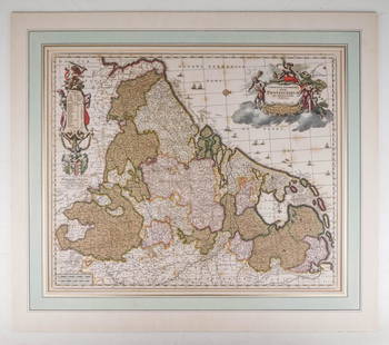
Sold2020Visscher, Claes .Germaniæ Inferioris XVIIVisscher, Claes .Germanie Inferioris XVII Provinciarum. Fine hand colored engraved double-page map. 18-1/2 x 22-1/2 inches plus margins, blank on verso, neatly matted; some browning, generally sound.See Sold Price
Sold20241746 Large Engraved Map New England Nova ScotiaA New Chart of the Coast of New England, Nova Scotia, New France or Canada with the Islands of NewFoundl(an)d, Cape Breton, St. John and C.. by Nicolas Bellin, English version printed for Gentleman'sSee Sold Price
Sold20171746 Leather Volume Map New England English Rebellion1746 Volume , featuring large folding “New Chart of the Coast of New England Nova Scotia, New France or Canada…”, of Gentleman’s Magazine for the year 1746 containing all twelve issues and SupSee Sold Price
Sold2016Nooks and Corners of The New England CoastBook Title: Nooks and Corners of The New England Coast Author: Samuel Adams Drake Publishing: New York, Harper and Brothers, 1876 459 pages Samuel Adams Drake (1833-1905) was a United States journalisSee Sold Price
Sold20181884 Captain John Smith Works maps New England VirginiaHard bound. Printed in England in 1884 Maps with some acid free tape repairs. Back cover is almost detached. Size 5 3/4 by 8" 982 pages Please note that this lot has a confidential reserve. When you lSee Sold Price
Sold2023Cartography14. Cartography.A New and Correct Map of the World According to the Latest Discoveries. Double-page engraved map. 17 x 26-1/2 inches, outlined in color; a few stains, hole at upper right corner, generSee Sold Price
Sold202318th century. A map of Portugal and Barbaria with the Canarie Isles. Mount & Page Tower Hill,18th century. A map of Portugal and Barbaria with the Canarie Isles. Mount & Page Tower Hill, London. Measures 25 x 19 inches. Overall fair condition; damage to edges and staining throughout.See Sold Price
Sold20231748 Map of North America, Comprehending 'The Course to Ohio'America, 18th century. An early map of the eastern coast, detailing New England, New York, and more. No maker marks present. Overall good condition; complete on laid paper.See Sold Price
1 day LeftJasper52Chart of the Newcastle Trade describing… coast of England. MOUNT & PAGE 1758 map$550
1 day LeftJasper52A New and Correct Chart of England, Scotland and Ireland. MOUNT & PAGE 1758 map$260
Featured1 day LeftJasper52A Chart of the Coasts of Ireland & part of England. Wales. MOUNT & PAGE 1758 map$550
1 day LeftJasper52Chart of the British Channel… Halley's tides & currents. MOUNT & PAGE 1758 map$750
1 day LeftJasper52The South-West Coast of Ireland from Dungarvan to… Shannon MOUNT & PAGE 1758 map$280
Featured1 day LeftJasper52The Seacoasts of Ireland from Dublin to London-Derry. MOUNT & PAGE 1758 map$280
1 day LeftJasper52Chart of the Sea Coasts Biscay & Gallicia [Galicia]. Spain MOUNT & PAGE 1758 map$360
1 day LeftJasper52A Large Chart of the Channell between England and France. Tides. HALLEY 1702 map$3,600
Featured1 day LeftJasper52A New and Correct Chart of the Harbour of Corke. MOUNT & PAGE/LINDSAY 1758 map$440
145 Lots AwayJasper521866 Johnson's Vermont, New Hampshire, Massachusetts, Rhode Island, and Connecticut$50
May 05Tremont AuctionsJohn Speed and Francis Lamb "Map of New England and New York", ca. 1676. Hand colored engraved map$600(2 bids)
May 10Rail & Road AuctionsSeven Panama Pacific Line Steamship Travel Guides, Timetable, and Menu - 1927 to 1939$30
Featured1 day LeftJasper52Antique sea 'Chart of the Islands of Cape Verd' [Verde]. MOUNT & PAGE 1758 map$260
May 09New England Auctions - Fred GiampietroDrink Dispenser with Glasses - Gilded Bronze Mount$125(3 bids)


![[Map] Coast of Georgia, S.C., Florida, Savannah: Hughes, Andrew. "A Draught of South Carolina and Georgia from Sewee to St. Estaca." London: W. Mount and T. Page, [1778.] Measured from neatlines 32.25" x 18". Professionally mounted at points to acid](https://p1.liveauctioneers.com/3532/146911/74242108_1_x.jpg?height=310&quality=70&version=1564368564)
![Mount & Page: Antique Coast Profile of Ireland, 1749: Title/Content of Map: '[A description of the sea coast of Ireland]' The following places are shown or referred to on the coastal profile chart: Galloway (Galway) Aran Islands Limerick Date Printed: 17](https://p1.liveauctioneers.com/5584/110608/56777156_1_x.jpg?height=310&quality=70&version=1507840413)


![Chart of the Sea Coasts Biscay & Gallicia [Galicia]. Spain MOUNT & PAGE 1758 map (1 of 1)](https://p1.liveauctioneers.com/5584/326140/175577208_1_x.jpg?height=282&quality=70&version=1713288521)

![The Sea Coast of France from Ushent to Olone [Olonne]. MOUNT & PAGE 1758 map (1 of 1)](https://p1.liveauctioneers.com/5584/326140/175576897_1_x.jpg?height=282&quality=70&version=1713288521)


![[WWI] P.T. Sherman's WWI Service Record & Books (1 of 8)](https://p1.liveauctioneers.com/7226/322253/173251586_1_x.jpg?height=282&quality=70&version=1710004847)


![Antique sea 'Chart of the Islands of Cape Verd' [Verde]. MOUNT & PAGE 1758 map (1 of 1)](https://p1.liveauctioneers.com/5584/326140/175576839_1_x.jpg?height=282&quality=70&version=1713288521)

