Sold201718th Century French Map of North AmericaL’Amerique Septentrionale. Daniel de la Feuille (1640-1709). Engraved map with hand color in full. Amsterdam, 1702 or 1706. 6 x 8 inches visible, 13 x 14 1/2 inches framed. Nicely colored early 18thSee Sold Price
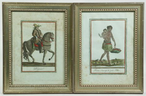
Sold2022(2) FRAMED 18TH C. FRENCH ENGRAVINGSLot of (2) Early French Hand Colored engravings, from "Costumes de Differents Pays" engraved by Jacques Grasset de Saint Sauveur (France, 1757-1810), L. Labrousse and J. Laroque, circa 1797, in matchiSee Sold Price
Sold20162 Early Maps of PennsylvaniaDESCRIPTION: Two early maps of Pennsylvania. Includes: 1) 1805 handcolored engraved map by John Carey in two parts. 17" x 21-1/4". Hinged at center. Small pinhole to York County. Light edge toning. CoSee Sold Price
Sold2023Antique Map of HispaniolaAntique Map of Hispaniola, "Hispaniolae, Cubae...", Ortelius, late 17th/early 18th c., hand-colored engraved map, sight 15 in. x 21 1/2 in., framedSee Sold Price
Sold2017J.-N. Bellin, "Plan de la Nouvelle Orleans""Plan de la Nouvelle Orleans", by Jacques Nicolas Bellin (French, 1703-1772), hand-colored copper engraved map on laid paper, from Abbe Antoine Francois Prevost'sL'Histoire Generale des Voyages..., voSee Sold Price
Sold20211757 Hand-Colored Map of Virginia and the ChesapeakeHistoric Maps Hand-Colored Map of Virginia and the Chesapeake Bay Area 1757, French and Indian War Period, Hand-Colored Engraved Map titled, "Carte De La Virginie, De La Baye Chesapeack et Pays VoisinSee Sold Price
Sold2021Jacques Nicolas Bellin MapsJacques Nicolas Bellin , "Plan de La Nouvelle Orleans" and "Carte des Embouchures du Mississipi", two hand-colored engraved maps, from Le Petit Atlas Maritime, 1764, 7 1/2 in. x 11 in., framed . ProveSee Sold Price
Sold2021Early Hand-Colored Map of VeniceItaly, ca. 16th-17th century. Fine hand-colored engraved map of "Venetia" with boats in harbor and compass rose. Handsomely framed. MEASUREMENTS Sight wide: 5 7/8 / 15 cm. Sight height: 4 1/2 / 11.5 cSee Sold Price
Sold2016Hand Colored Engraved Map,Hubert JaillotAfter Hubert Jaillot (1632-1712) "Amerique Septentrionale divisee on ses principales parties". Hand colored engraved map of North American under the French power of Louis XIV. [Sight: 22 1/2" H x 35"See Sold Price
Sold2017America, Rare Early Map of the Americas"America", Rare Early Map of the Americas by Jodocus Hondius (Flemish/Dutch, 1563-1612) for a French edition of Mercator's Atlas, North and South America, hand-colored copper engraved map, published ASee Sold Price
Sold2020EARLY FRENCH MAP OF NEW ENGLANDHand-colored. Ca 1750-1760. Map in French. Map 14 1/2 x 12 1/2 inches. Fold marks and water stains. Overall 21 inches x 19 inches. Stains and cut down.See Sold Price
Sold2017Janssonius: Antique Map of Virginia to Florida, 1639Map: Virginia to Florida Date Printed: 1639 Cartographer: Janssonius Joannes Material/Medium: Paper Size: 21 1/2" x 17 1/4" Hand colored, copperplate engraved. French edition. Virgina to Carolna coastSee Sold Price
Sold2021Antique MapsGrouping of Two (2) Antique Engraved Maps. Includes a J.H. Colton & Co hand colored map of Cuba, Jamaica, and Puerto Rico together with a Jacques-Nicolas Bellin "Carte de la Nouvelle Angleterre, NouveSee Sold Price
Sold2021Two Early Hand-Colored Engraved MapsA pairing of early hand-colored engraved maps to include Roma and Orvieto and Lav Retum by Georg Braun (1541-1622) and Frans Hogenberg (1540-1590). Both framed under glass. Frame opening of larger: 15See Sold Price
Sold2018ATTRIBUTED TO WILLEN BLAEU 2 ENGRAVED MAPSATTRIBUTED TO WILLEN BLAEU, 2 HAND COLORED ENGRAVED MAPS, "NAVA BELGICA" & "MAPPA AESTIVARUM", 15 1/4" X 19 3/4" & 16" X 21" DATES OF PRINTING ARE UNKNOWN; FRAMED. ARNOLD KLEIN FRAMING LABEL.See Sold Price
Sold2023TWO ANTIQUE AFRICAN MAPS.Early hand colored engraved map of North Africa by Edward Wells, ca. 1700, “A New Map of the North Part of Antient Africa..” image 14.25” x 19”, overall 22” x 27”.See Sold Price
Sold2021Two Early Engraved Maps: Ireland & GloucestershireA pairing of early hand-colored engraved maps to include a Christopher Saxon and William Hole map of "Glocestriae Comitatus Olim Sedes Dobuncrum", and a William Hole map of Ireland titled "Hiberniae".See Sold Price
Sold2021Two Early Framed Engraved MapsA lot of two early hand-colored engraved maps to include a W. J. Bleau map of Amsterdam, ca. 1634-1635, "Sabaudia Ducatus Savoye", together with a John Speed map of Britain, ca. 1611-1614, "DevonshireSee Sold Price
Sold2018Colton: Antique Map of West Indies, 1859Title/Content of Map: West Indes by Colton Date Printed: 1859 Cartographer: H.J. Colton Material/Medium: Paper Size: 17 1/2" x 14 1/2" Hand colored engraved Map. Publsihed in New York in 'Colton's GenSee Sold Price
Sold2021Map of City and Harbour of MacauA Plan of the City and Harbour of Macao" engraved by B. Baker, Islington 27" x 20 1/2" (sight) hand-colored engraved map 18th century framed- 32 1/2" x 40See Sold Price
Sold2017Colton: Antique Map of South America, 1861Title/Content of Map: South America Date Printed: 1861 Cartographer: J.H. Colton Material/Medium: Paper Size: 14" x 17 1/2" Hand colored steel engraved Map from 'Colton's General Atlas'. Published inSee Sold Price
Sold2023ANTIQUE 18TH C HAND COLORED MAP OF OTTOMAN EMPIREAn antique early 18th-century hand-colored engraved map representing the Ottoman Empire. Published in Nuremberg, Germany, 1720. Titled Imperium Turcicum, technical information in Latin in the lower leSee Sold Price
Sold2018Colton: Antique Map of North America, 1859Title/Content of Map: North America by Colton Date Printed: 1859 Cartographer: H.J. Colton Material/Medium: Paper Size: 17 1/2" x 15" Hand colored, engraved Map. Published in New York in Colton's 'GenSee Sold Price
Sold20231859 Southern Africa. Map By ColtonTitle: 1859 Southern Africa. Map By Colton Date/Period: 1859 Materials: Hand colored steering engraved Size: 17 1/2 x 14 1/2” This hand-colored, steel-engraved map showcases the region from theSee Sold Price
May 01Doyle New YorkVaugondy's map of Virginia and Maryland, a reduction of Fry and Jefferson's landmark map$600
2 days LeftRalph Fontaine Heritage Auctions Inc.2 French Hand Drawn Engraved And Hand Colored By Francois Nicolas Martinet (1731-1800)$50
May 04Auction WallstreetEngraving on glass Johannes Kip La Ville de Londres Prospectus Londinensis City of London$750