2022Allard, Carel (Netherlands, 1648-1709) World Map C.1696Flat Globe Commonly Called The Whole World Sight View 20-1/2" x 23-3/4", Overall 21-1/4" x 25" "Planispharium Terrestre, Sive Terrarum Orbis, Planispearice Constructi Representatio QuintupleSee Sold Price
Sold2017Millar: Antique Map Netherlands Belgium Luxenburg, 1768Title/Content of Map: 1768 Millar Map of Netherlands, Belgium, Luxenburg -- A New and Accurate Map of the Seven United Provinces Imcluding the Dutch Netherlands & e. Date Printed: 1768 Cartographer: GSee Sold Price
Sold2022Lizars, Daniel 1831 LG Rare HC Map. Netherlands - Dutch ProvincesLarge Folio Copper Engraved Map Published 1831-2 by John Hamilton, Successor to Daniel Lizars, Edinburgh for "The Edinburgh Geographical and Historical Atlas..." First Edition by Daniel Lizars. Very fSee Sold Price
Sold2020Barclay, James C1835 Pair of Hand Col Maps. NetherlandsHand Colored Copper Engraved Map Published C1835, London for "A Complete and Universal English Dictionary" by the Rev. James Barclay et al. Folds as issued. Paper Size: 11 x 8.5 inch (28 x 22cm) GoodSee Sold Price
Sold2021Guthrie, William 1790 Antique Map. NetherlandsCopper Engraved Map Published 1790, London for "A New Geographical, Historical and Commercial Grammar..." by William Guthrie. The maps are by John Senex, Thomas Kitchin and others. Folds as issued. EaSee Sold Price
Sold2022Lizars, Daniel 1831 LG Rare HC Map. Netherlands - Belgic ProvincesLarge Folio Copper Engraved Map Published 1831-2 by John Hamilton, Successor to Daniel Lizars, Edinburgh for "The Edinburgh Geographical and Historical Atlas..." First Edition by Daniel Lizars. Very fSee Sold Price
Sold2022Barclay, James 1812 Hand Col Map. Netherlands"The Severn United Provinces..." Hand Colored Copper Engraved Map Published 1812-13 by Brightly & Childs, Bungay for "A Complete and Universal Dictionary of the English Language..." by the Rev. JamesSee Sold Price
Sold2021Barlow 1807 Antique Map. NetherlandsCopper Engraved Map Published 1807 by Brightly & Kinnersley, Bungay, England for "A General View of the World, Geographical, Historical and Philosophical" by The Rev. E. Blomfield. Engraved by Barlow.See Sold Price
Sold2022Barclay, James 1812 Hand Col Map. NetherlandsHand Colored Copper Engraved Map Published 1812-13 by Brightly & Childs, Bungay for "A Complete and Universal Dictionary of the English Language..." by the Rev. James Barclay. Paper Size: 10.5 x 8 incSee Sold Price
Sold2022Barlow 1807 Antique Map. Netherlands HollandCopper Engraved Map Published 1807 by Brightly & Kinnersley, Bungay, England for "A General View of the World, Geographical, Historical and Philosophical" by The Rev. E. Blomfield. Engraved by Barlow.See Sold Price
Sold2021Guthrie, William 1798 Pair of Maps. Netherlands HollandCopper Engraved Map Published 1798, London for "A New Geographical, Historical and Commercial Grammar..." by William Guthrie. The maps are by John Senex, Thomas Kitchin and others. Folds as issued. PaSee Sold Price
Sold2024Russell & Allen (Pub) 1812 Map. NetherlandsFolio Copper Engraved Map Published 1812 by Russell and Allen, Manchester for "A New And Commercial System Of Geography" Paper Size: 15.5 x 9 inch (39 x 23cm) Some tone spotting, otherwise Good ConditSee Sold Price
Sold2023Thomson, John (Pub) 1825 Map. NetherlandsCopper Engraved Map Published 1825 by John Thomson, Edinburgh for "The Edinburgh School Atlas" by N. R. Hewitt. Maps Engraved by Hewitt. Original Outline Hand Colour. Rare. Paper Size: 10.5 x 8 inch (See Sold Price
Sold2021Lochhead (Pub) 1811 Rare Map. Netherlands Holland"The Severn United Provinces with the Dutch and Austrian Netherlands" Copper Engraved Map Published 1811 by William Lochhead, Berwick for "Modern Geography: And a Compendious General Gazetteer" Rare.See Sold Price
Sold2023Turner, Richard 1805 Pair of Miniature Maps. NetherlandsUnited Provinces and The Netherlands. Copper Engraved Map Published 1805, London for "A New and Easy Introduction to Universal Geography..." by the Rev. Richard Turner. Paper Size: 5.5 x 3.5 inch (14See Sold Price
Sold2021Guthrie, William 1806 Map. NetherlandsCopper Engraved Map Published 1806, London for "A New Geographical, Historical and Commercial Grammar..." by William Guthrie. The maps are by John Senex, Thomas Kitchin and others. Folds as issued. PaSee Sold Price
Sold2019Barclay, James 1809 Antique Map. Netherlands & Belgium"The Seven United Provinces, with The Dutch Possessions in Flanders, Brabant and Limburg" Outline Hand Coloured Copper Engraved Map Published 1809, Leeds for "Barclay's Complete and Universal DictionaSee Sold Price
Sold2024Set of 4 Maps - Netherlands - Seven United Provinces - Germany - Sweden, Denmark, Norway, FinlandSet of 4 engraved maps by J. Barlow. Size: 20 cm x 24 cmSee Sold Price
Sold2024Set of 3 Maps - Netherlands - Belgien - Switzerland - J. BarlowSet of 3 engraved maps, by J. Barlow and more. Size: ca 20 cm x 25 cmSee Sold Price
Sold2017Allard Map of America with California as Island, 1697Map: Allard Map of America with California as Island - Recentissima Novi Orbis sive Americae Septentrionalis et Meridionalis Tabula Cartographer: C. Allard Date: ca. 1697 Size: 19 x 22.5 inches Nice lSee Sold Price
Sold2019Netherlands and BelgiumTitle/Content of Map: Netherlands and Belgium Date: 1861 Cartographer: Johnson Material/Medium: steel engraved Size: 18x14” Provenance: New York Additional Info: Hand colored Reserve: $20.00 ShippinSee Sold Price
Sold2023Carel Allard, Map the Sevennes Region in South Central FranceCarel Allard, Map the Sevennes Region in South Central FranceAmsterdam, early 18th century, copperplate engraving with outline color; focusing of the Diocese of Monpellier; matted and framed under glaSee Sold Price
Sold20191720 Homann Map of Netherlands, Belgium and LuxemburgReserve Reduced! Map Title/Content: 1720 Homann Map of Netherlands, Belgium and Luxemburg -- Tabula Generalis Totius Belgii qua Provinciae XVII. Infer. Germaniae olim sub S.R.I. Circulo Burgundiae…See Sold Price
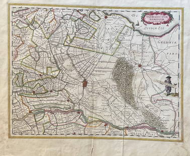
Sold2023The Netherlands Map. The region Around the city of Utrecht. 1660?s by W. BlaeuTitle: The Netherlands Map. The region Around the city of Utrecht. 1660?s by W. Blaeu Date/Period: 1660?s Materials: Hand colored copper plate engraved Size: 22 x 19 1/2'' Netherlands regional map cenSee Sold Price
May 10Rail & Road Auctions1934 Short Line Motor Coach Service Timetable and 1947 Michelin Map 6 of Netherlands$20
May 09Hunt and Peck Estate Services, Inc.1713 Tho. Brodrick "A Compleat history of the late war in the netherlands$50
Featured6 hrs LeftJasper521749-59 21 volumes NETHERLANDS HISTORY ILLUSTRATED antique VELLUM BOUND$1,400
May 16Potter & Potter AuctionsGEESINK, Joop (1913 – 1984). Europa. 1957. Netherlands: KLM...$100
1 day LeftJasper52Zelanda, e parte orientale della Flandra. Flanders & Zeeland. CORONELLI 1696 map$360
May 01Doyle New YorkWilliam Mudford's An Historical Account of the Campaign in the Netherlands in 1815...$1,000
4 days LeftTrillium Antique Prints & Rare BooksBraun & Hogenberg, pub. 1575 - View of Utrecht, Netherlands$100
May 01Doyle New YorkA 15th-century Breviarum Minorum from the library of an accused Episcopalian heretic$5,000
May 14Fleischer's Auctions1755 Map Partie de l'Amerique Septentrionale, qui comprend Le Cours de L'Ohio...$200(3 bids)
May 05Tremont AuctionsJohn Speed and Francis Lamb "Map of New England and New York", ca. 1676. Hand colored engraved map$600(2 bids)
May 05Tremont Auctions17th century original map 1676 "Virginia and Maryland" by John Speed. 2 sided framing. Overall:$300(1 bid)
3 days LeftLeland LittleAmbrosius Macrobius's Commentary on Cicero's The Dream of Scipio , with Rare Woodcut Map$325(4 bids)