Sold2023c 1706 Pieter Van Der Aa North + South America Map as 1st Discovered by ColumbusHistoric Maps 1706 North & South America Map Discovered by Columbus First Voyage Published by Dutch Map Pieter Van Der Aa (1659-1733) c. 1706-1708, Original Map of North & South America (translated) tSee Sold Price
Sold2021Russell, William 1778 Rare Map Tierra Fierma, Americas"An Exact Map of the Provinces of Tierra Fierma, Darien, C" Copper Engraved Map Published 1778, London for "The History of America, From Its Discovery by Columbus to the Conclusion of the Late War" bySee Sold Price
Sold2021Russell, William 1778 Rare Map Tierra Fierma, Americas"An Exact Map of the Provinces of Tierra Fierma, Darien, C" Copper Engraved Map Published 1778, London for "The History of America, From Its Discovery by Columbus to the Conclusion of the Late War" bySee Sold Price
Sold20241717 MAP of AMERICA antique authentic CALIFORNIA AS AN ISLAND L'AmeriqueAmericas. L'Amerique, Meridionale et Septentrionale Dressee Selon les Dernieres Relations et Suivant les Nouvelles Decouverte... by Fer (Nicholas de) (1646-1720) engraver Inselin, C. A Paris :b Chez lSee Sold Price
Sold20231631 c. Blaeu Map of the Americas -- Americae nova TabulaTitle: 1631 c. Blaeu Map of the Americas -- Americae nova Tabula Cartographer: W Blaeu Year / Place: 1631 c., Amsterdam Map Dimension (in.): 14.3 X 18.3 in. This is a very nice map portraying the seveSee Sold Price
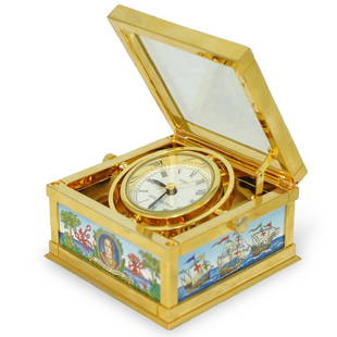
Sold2019Halcyon Days Enamel ClockDESCRIPTION: A Halcyon Days Christopher Columbus Enamel Table Clock. Features enameled decoration with Christopher Columbus motif and a map of the Americas, top opens and clock face lifts up. Marked oSee Sold Price
Sold2024c. 1598 ORIGINAL MAP OF THE AMERICAS, ORTELIUS-RUSCELLI-ROSACCIO, SCARCE EDITIONc. 1598 ORIGINAL MAP OF THE AMERICAS, ORTELIUS-RUSCELLI-ROSACCIO, SCARCE EDITION. Sheet Size: 240 x 350mm – 9 ½ x 13 7/8 inches’’ Image Size: 190 x 250mm – 7 51/4 x 10 inchesSee Sold Price
Sold2019Moll Map of Peru and AmazonMOLL, Herman (1654-1732). A Map of Peru and the West Part of the Country of the Amazones. Engraved map from Atlas Geographus. London, c. 1711-1717. 13 1/4" x 8 1/2" sheet.See Sold Price
2017Guillaume Delisle, map of AmericasGuillaume Delisle, map of Americas, Guillaume Delisle (French, 1675-1726), "Carte d'Amerique, dressee pour l'usage du Roy", c. 1739, engraving with period country boundaries outlined in color, 21.25"hSee Sold Price
Sold2022JOHN SPEED 17TH C. MAP, AMERICA.John Speed map of the Americas, engraved with hand coloring, bordered on three sides with depictions of native peoples from Florida, Virginia, New England, and with city views including Havana, Cuzco,See Sold Price
Sold2022Blaeu Brasilia, c 1640BLAEU, Joan Blaeu (1596-1673). Brasilia... Engraved map with original hand color in part. Amsterdam, c. 1640. 19 7/8" x 23 3/8" sheet. A fine and attractive map of Brasil, first discovered by Pedro ?lSee Sold Price
2021Michael Mercator RARE Antique Map of the AmericasAntique map of "America and New India" (America Sive India Nova) produced by Michael Mercator (c. 1567-1600), Gerard Mercator’s grandson. Hand colored engraved map. Duisburg, 1595 (Amsterdam, 1See Sold Price
Sold2023Ogilby / Montanus Map of the AmericasOGILBY, John (1600-1676) / MONTANUS, Arnoldus (c. 1625–1683). Insulae Americanae in Oceano Septentrionali cum Terris adiacentibus. Engraved map. London, 1671 (Second state). 16" x 20 1/2" sheet, 33"See Sold Price
Sold20221685 Map of the Americas, w/California an IslandHistoric Maps Hand-Colored Map titled, "L'AMERIQUE SUIVANT LES DERNIERES OBSERVATIONS," of North and South America with California shown as a Separate Island c. 1685, Copper Plate Engraved, Hand-ColorSee Sold Price
Sold20231759 Tirion Map of the Americas -- Nieuwe Kaart van America…Title: 1759 Tirion Map of the Americas -- Nieuwe Kaart van America… Cartographer: I Tirion Year / Place: 1759 c., Amsterdam Map Dimension (in.): 10.8 X 12.5 in. This is wonderful map of the AmerSee Sold Price
Sold20231950s PanAm Route Map of South America's East Coast -- Pan American Flight Map, South America EastTitle: 1950s PanAm Route Map of South America's East Coast -- Pan American Flight Map, South America East Coast Cartographer: PanAm Year / Place: late 1950s c. Map Dimension (in.): 23.5 X 16.8 in. folSee Sold Price
Sold20191850 c. Becker map of North and South America --Title/Content of Map: 1850 c. Becker map of North and South America -- America Date: 1850 c., London Cartographer: F Becker & Co. Size: 10.1 x 8 in. This is an interesting map of the Americas, offerinSee Sold Price
2018Becker: Antique Map of North and South America, 1850Title/Content of Map: 1850 c. Becker map of North and South America -- America Date Printed: 1850 c., London Cartographer: F Becker & Co. Size: 10.1 x 8 in. This is an interesting map of the Americas,See Sold Price
Sold2020Bowen, Thomas 1789 Map of North America. USA Canada"A New & Accurate Map of North America including Nootka Sound, with the new discovered Islands on the North East Coast of Asia" Copper Engraved Map Published 1789-91 by C. Cooke, London for "The New RSee Sold Price
Sold2016*ANTIQUARIAN 17TH C. HANDCOLORED ENGRAVED MAPAmerica's northeast state coast line with Massachusetts, New York and possibly Virginia, as well as unexplored provinces of Canada including Quebec, approximate plate size 15" x 20", frame 21 1/2" x 2See Sold Price
Sold2018MEXICAN or SOUTH AMERICAN COLONIAL EMBROIDERY, 19th C.Framed colorful silk embroidered picture of Columbus landing on the shores of the Americas, surrounded by priests, soldiers, Native Americans and animals, the Nina, Pinta, and Santa Maria in the backgSee Sold Price
Sold2022c. 1717 William Bradford American WOODBLOCK PlateColonial America William Bradford Colonial American Astronomical Image Woodblock Printing Plate "Half-Eclipse With a Smiling Human Face" as Used for Various Published Illustrations c. 1717 Colonial ErSee Sold Price
Sold2022N Am.18th C Map W & I Mount & T. PageNorth American Map. Hand Colored map "A Chart of the Sea Coast of New Foundland, New Scotland, New England, New York, New Jersey with Virginia and Maryland" by W & I Mount & T. Page on Tower Hill LondSee Sold Price
Sold201819th C Map Oregon, Washington, Idaho, & Part of Montana**Originally Listed At $100** Samuel Augustus Mitchell Jr. (American), "Map of Oregon, Washington, Idaho and Part of Montana." ca. 1860. A fabulous example of S. A. Mitchell Junior's 1866 map of WashiSee Sold Price
5 days LeftJasper52Antique engraving. Mariamne. Etching. James Dobie after John William Waterhouse (c. 1888)$70
May 18Rich Penn AuctionsDecorative Art, map of South America, late 18th C., framed & matted, Exc cond, 24"H x 20"W overall.$50
15 hrs LeftAlexander Historical Auctions LLCBATTLE OF ST. MIHIEL BATTLE MAP, USED BY COL. WILLIAM J. DONOVAN$140
15 hrs LeftAlexander Historical Auctions LLCCAPTURED MAP OF VERDUN, USED BY COL. WILLIAM J. DONOVAN$100
21 hrs LeftFive Star AuctionsThe Columbus Egg, A Teo Faberge 500th Anniversary Of The Discovery Of America Egg, Closed Edition$9,000
May 14Fleischer's AuctionsLincoln's Funeral Cortège Book by Custodian of Lincoln's Tomb$150(2 bids)
15 hrs LeftAlexander Historical Auctions LLCSECOND BATTLE OF THE MARNE MAPS, USED BY COL. WILLIAM J. DONOVAN$240
15 hrs LeftAlexander Historical Auctions LLCSECOND BATTLE OF THE MARNE MAPS, USED BY COL. WILLIAM J. DONOVAN$140
5 days LeftAdam's AuctioneersH.C CAREY AND I.LEA (publishers) A Complete Historical, Chronological and Geographical AMERICAN€1,500
2 days LeftTrillium Antique Prints & Rare BooksPrichard - 7 Native American Aquatint Engravings$35(1 bid)
C & T Auctioneers and Valuers LtdScarce Matchbox Series Regular Wheels UK Issue Shop Retailers Display Stand£2,000(1 bid)
May 04Jay Anderson AuctionC 1875 Burl Walnut Bullseye American made Walnut Victorian 3 Pc Marble Top Massive Bedroom Set .$1,900(6 bids)
2 days LeftBidhausHigh Back Mid Century Modern Lounge Chair & Ottoman After Hans Wegner in Knoll Fabric USA c. 1960s$205(5 bids)