Sold20191848 New York History 59 County Atlas Maps Dutch1848 New York History 59 County Atlas Maps Dutch Colonial Mather ‘A Geographical History of the State of New York’ is a text with detailed sections on the physical features of the state, its naturSee Sold Price
Sold20231848 NEW YORK Geography History County Maps NY Constitution Dutch Influence1848 NEW YORK Geography History County Maps NY Constitution Dutch Influence “A Geographical History of the State of New York” by Mather and Brockett is a pre-Civil War 19th-century accountSee Sold Price
Sold20171850 1ed History of New York Dutch Immigration Maps1850 1ed History of New York Dutch Immigration Illustrated MAPS Macomb Purchase This first edition report on the state of New York. This pamphlet includes incredible folding maps and engravings includSee Sold Price
Sold2022NYS & St. Lawrence County Geography Books3 books to include: History of New York State Biographical 1523-1927; New York State Gazetteer 1860 and a Geography of St. Lawrence County with Map by Blankman.See Sold Price
Sold2017Columbia County New York AtlasColumbia County New York Atlas. Published 1976. No. 281/300 copies. Along with Claverack map, Saratoga Springs High School diploma, Geological Survey map.See Sold Price
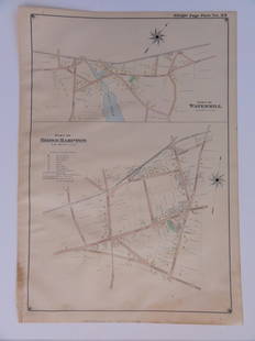
Sold2015Town of Dover in Dutchess County, Atlas of New York byOriginal steel engraving by Augustus Mitchell, 1881. Map features city streets & railroads. Dimensions: 15” x 12”See Sold Price
Sold2021Pictorial Map Mohawk IndiansMap of the Land of The Mohawks of Sir William Johnson, of the Palatines and the Mohawk Dutch. Edwin G. Conde, 1932. Native Americans historical map, Counties in New York State. 18 3/4" x 34 1/4".See Sold Price
Sold2021Beers & Co 1873 Atlas Columbia County, NY w/ Color Maps1873 Atlas of Columbia County New York, with engravings by Worley & Brocher. First edition hardcover folio with debossed covers and gilt title. Atlas pages have amazingly detailed and colorful hisSee Sold Price
Sold2019Atlas of Westchester County New York Joseph R BienAtlas of Westchester County New York Joseph R Bien. Two bound folios containing maps of Westchester County New York prepared under the direction of Joseph R Bien, published in 1893. Each folio measureSee Sold Price
Sold2021HISTORICAL ATLAS OF DUTCHESS COUNTY NEW YORKHISTORICAL ATLAS OF DUTCHESS COUNTY NEW YORK ILLUSTRATED - READING PUBLISHING HOUSE 1876. IN GOOD ESTATE CONDITION, FROM HOUSE IN STANFORDVILLE, N.Y. BEAUTIFUL MAPS AND ILLUSTRATIONS. HARD ATLAS TO FISee Sold Price
Sold2021Atlas entitled "COUNTY ATLAS OF ULSTER NEW YORK" byAtlas entitled "COUNTY ATLAS OF ULSTER NEW YORK" by F.W. Beers, published by Walker & Jewett, 1875. Due to the odd manner in which pages are numbered, difficult to determine if maps are actually missiSee Sold Price
Sold20231869 Beers Atlas of Clinton County, New York1869 Beers, Ellis and Soule Atlas of Clinton County, New York, leather spine split, otherwise fair condition, fold out map of Plattsburgh loose and mended with old cloth tape. 16" x 13"See Sold Price
Sold2021Atlas entitled "NEW ILLUSTRATED ATLAS OF DUTCHESSAtlas entitled "NEW ILLUSTRATED ATLAS OF DUTCHESS COUNTY NEW YORK" by O.W. Gray & Son - Reading Publishing House, Reading Pa. 1876. Book is complete with supplements and some maps with hand tinting. MSee Sold Price
Sold2021Early Rand McNally Atlas Maps in Poster Frames (2)1) New York City showing portions of Jersey City, Brooklyn, and Westchester County - 1892 - (22" x 34" in frame); 2) San Francisco, Ca., with inset of Bay Area - 1891 (22" x 34" in frame).Date: 1891-1See Sold Price
Sold2016Town of Southampton Map (North Haven & Art Village),Original engraving of Southhampton town, including Peconic Bay, Hobson Island and many landmarks & family names. Published by E. Belcher Hyde from "Atlas of Suffolk County, Long Island, New York," 190See Sold Price
Sold2016Bridgehampton & Watermill, Long Island, 1902Original engraving published by E. Belcher Hyde from "Atlas of Suffolk County, Long Island, New York," Philadelphia, 1902. Map features family names, historic buildings and railroad routes. DimensionsSee Sold Price
Sold2017NEW CENTURY ATLAS OF COUNTIES OF THE STATE OF NEW YORK,NEW CENTURY ATLAS OF COUNTIES OF THE STATE OF NEW YORK, EVENTS PUB. CO., 1912; (42) COLORED MAPS. 26 X 20" (IMPERFECTIONS)See Sold Price
Sold2022Scarce early Cram RR map of New YorkExceedingly scarce New York state map from the last Cram atlas to feature hand colored maps. “New Railroad and County Map of New York” from the very scarce 1882 Cram’s Unrivaled FamSee Sold Price
Sold2023Antique Hand Colored Maps of Westchester County NYAntique Hand Colored Maps of Westchester County NY. This lot includes four 19th century hand colored maps from the "Atlas of New York and Vicinity" by F.W. Beers. Includes one map of Bedford, one mapSee Sold Price
Sold2018Antique Hand Colored Maps of Westchester County NYAntique Hand Colored Maps of Westchester County NY. This lot includes four 19th century hand colored maps from the "Atlas of New York and Vicinity" by F.W. Beers. Includes one map of Mamaroneck/Rye NeSee Sold Price
Sold2018Antique Hand Colored Maps of Westchester County NYAntique Hand Colored Maps of Westchester County NY. This lot includes four 19th century hand colored maps from the "Atlas of New York and Vicinity" by F.W. Beers. Includes one map of Bedford, one mapSee Sold Price
Sold2018Antique Hand Colored Maps of Westchester County NYAntique Hand Colored Maps of Westchester County NY. This lot includes four 19th century hand colored maps from the "Atlas of New York and Vicinity" by F.W. Beers and the Planning Board/Technical AdvisSee Sold Price
Sold2018Antique Hand Colored Maps of Westchester County NYAntique Hand Colored Maps of Westchester County NY. This lot includes four 19th century hand colored maps from the "Atlas of New York and Vicinity" by F.W. Beers. Includes one map of Port Chester, oneSee Sold Price
Sold2018Antique Hand Colored Maps of Dutchess County, NY.Antique Hand Colored Maps of Dutchess County, NY. This lot includes three 19th century hand colored maps from the "Atlas of New York and Vicinity" by F.W. Beers. Includes one map of Hyde Park, one mapSee Sold Price
May 12Schilb Antiquarian Rare Books1881 Westchester County New York Yonkers Illustrated MAPS 2v SET Bolton History$1(1 bid)
May 14Fleischer's Auctions1755 Map Partie de l'Amerique Septentrionale, qui comprend Le Cours de L'Ohio...$300(3 bids)
5 days LeftThe Benefit Shop Foundation Inc.Vtg Bromley Atlas Borough of Manhattan Illustr$175(4 bids)
6 days LeftJasper52Océanique Partie de la Nle Zélande 59 New Zealand North Is VANDERMAELEN 1827 map$260
4 days LeftJasper521850 Pease Map of Albany from the 1770 -- Plan of the City of Albany about the Year 1770$55
4 days LeftJasper521867 Beers Map of Parts of Weschester Co., New York In cluding Tarrytown -- Plan of Beekmantown,$80
4 days LeftJasper521867 Beers Map of Ossining with Sing Sing Prison in New York -- Sing Sing, The Town of Ossining,$80