Sold2017Colton: Antique Map of Texas, 18641860 Colton’s Texas - uncommon. From an 1864 school atlas. This map is not seen very often. Delineates all counties to 1860. Shows topography, forts, railroads, battle fields, rivers, etc. �See Sold Price
Sold2017Mitchell: Antique County Map of Texas, 1873Excellent 1873 County Map of Texas by S. Augustus Mitchell. Impressive two-page County Map of the State of Texas. Map image much larger than earlier Mitchell maps. Designed and engraved by W. H. GamblSee Sold Price
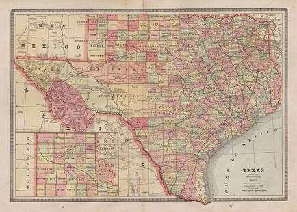
Sold2017Mitchell: Antique County Map of Texas, 1870Map: County Map of Texas Cartographer: S. A. Mitchell Place & Date: Philadelphia / 1870 Size: 13 1/4" x 10 3/4" Condition: full color; light overall age toning The beautifully detailed and colored couSee Sold Price
Sold2018Cram Map of TexasCRAM, George F (1842-1928). Railroad and county map of Texas. Lithograph with handcolor, with original black slipcase on the verso. Chicago, 1876. 17 3/4 x 24 inches sheet, 28 x 33 inches framedSee Sold Price
Sold2021Colton Railroad and County Map United States 1878Colton, after G. W., Colton's Railroad and County Map of the United States, The Canadas, &c, 1878, antique map on paper, folded as originally issued, 33 x 42 inches, in a wood frame 36.5 x 47.5 inchesSee Sold Price
Sold2020Rand McNally & Co., County and Railroad Pocket MapRand McNally & Company, Indexed County and Railroad Pocket Map and Shipper's Guide of Texas, Chicago 1904 image size: 24 x 16", frame: 28 x 17.5" Fine separately published map of Texas, colored by couSee Sold Price
Sold2021Antique New York State Map 1903 Color Roll Up RR Map1903 Scarborough's New Railroad, Post Office, Township and County Map of New York. Color map, compiled from the latest government and state surveys and original sources of the era. Insets: Map of NewSee Sold Price
Sold2022County Map of The State of California 1881Rare antique map of the state of California showing counties, waterways, railroad routes and townships. "Entered according to Act of Congress in the year 1880 by S Augustus Mitchell in the office of tSee Sold Price
Sold2022County Map of Kentucky and Tennessee 1881Rare antique map of Kentucky and Tennessee showing counties, waterways, railroad routes and townships. "Entered according to Act of Congress in the year 1880 by S Augustus Mitchell in the office of thSee Sold Price
Sold2017Hardesty: Antique Map of Texas, 1875Large and fully hand-colored map from the very scarce 1875 Jones and Hamilton Historical Atlas of the World Illustrated. Colored by county. This is a quality map, lithographed on good paper. DepictedSee Sold Price
Sold2022Scarce Texas map (eastern part) from Asher & Adams,County map of Eastern Texas extends from Louisiana west to beyond San Antonio and features the railroad system of that time. Features numerous railroads still in their infancy, along with proposed futSee Sold Price
Sold20221885 Two-page Railroad map of TexasCram’s 1885 double-page railroad map of Texas has exceptional printed color. Every railroad line in the state is highlighted in a heavier black line than such things as county borders, rivers anSee Sold Price
Sold2022Asher & Adams' unique RR map of Texas, 1871County map of East Texas depicted in the unique Asher & Adams’ style, without roads to highlight the presence of railroads. Extends from Louisiana west to beyond San Antonio and features the raSee Sold Price
Sold20231902 National Publishing Company Wall Map1902 roll down wall map printed by the National Publishing Company New Railroad, Post office, Township, and County Map of New York which measures approximately 48" by 41". Condition - fine.See Sold Price
Sold2016scarborough's map of new york 19031903 Scarborough's new railroad, post office, township and county map of New York with distances between stations. Tears; stained; needs repair. 49 1/2 inches wide x 40 inches high.See Sold Price
2017Burgess: Antique Map of the United States, 18531853 Map of the United States with large Texas. Daniel Burgess. Delightful early school atlas map of the region. Shows counties, parishes, towns, rivers, populations, Indian Tribes, Court Houses, FortSee Sold Price
Sold2021Scarce 1853 Texas map by Roswell SmithAntique and hard to find antebellum map with full original hand coloring. Engraving on paper. Shows forts, rivers, locations of tribes, towns, counties and topographical features. Eastern Indian TerriSee Sold Price
Sold20171855 Barnes's Map of Pennsylvania. A new county m1855 Barnes's Map of Pennsylvania. A new county map of Pennsylvania and adjoining states. Showing Central and other railroads.-- Dimensions: H: 26 inches: W: 37.5 inches ---See Sold Price
Sold2020AN ANTIQUE MAP, "New Railroad Map of the United States,AN ANTIQUE MAP, "New Railroad Map of the United States, the Dominion of Canada, Mexico and the West Indies," CHICAGO, CIRCA 1875, hand-colored lithograph on paper, publishing, engraving, and printingSee Sold Price
Sold2016Antique Map, County of Southampton, Greenwood & Co.Greenwood & Co. (British, 19th century), "Map of the county of Southampton from an Actual Survey, made in the years 1825 & 1826," hand-colored copper-engraved map, engraved by J. and J. Neele, publishSee Sold Price
Sold2023Antique Map County of Cumberland EnglandAntique Framed and Hand Colored Map of the County of Cumberland, England by Richard Blome (London Engraver 1600-1705) . 16 inches x 13 inchesSee Sold Price
Sold2023Antique Map County of Northumberland EnglandAntique Framed and Hand Colored Map of the County of Northumberland, England by Richard Blome (London Engraver 1600-1705) . 16 inches x 13 inchesSee Sold Price
Sold2016Antique Map, County of Dorset from an Actual Survey,Greenwood & Co. (British, 19th century), "Map of the county of Dorset from an Actual Survey, made in the years 1825 & 1826," 1829, hand-colored copper-engraved map, engraved by H. Frost, published inSee Sold Price
Sold2022SAMUEL AUGUSTUS MITCHELL JR., AN AMERICAN CIVIL WAR ERASAMUEL AUGUSTUS MITCHELL JR., AN AMERICAN CIVIL WAR ERA MAP, "County Map of Texas," CIRCA 1863, hand-colored lithograph on paper with profusely floral and fruit border, plate 34. from Mitchell's New GSee Sold Price
2 days LeftJasper52Merioneth Shire Described county map by John Speed. George Humble edition 1627$360
2 days LeftJasper52Shropshyre. Shropshire county map by John Speed. Bassett & Chiswell edition 1676$360
2 days LeftJasper52Westmoria Comitatus; Anglice Westmorland. Westmoreland county map by Blaeu 1645$280
2 days LeftJasper52Yorkeshyre. Yorkshire West Riding county map by John Speed. Overton edition 1710$800
2 days LeftJasper52Darbieshire. Derbyshire county map by John Speed. Bassett/Chiswell edition 1676$440
2 days LeftJasper52Darbieshire. Derbyshire county map by John Speed. Bassett/Chiswell edition 1676$440
2 days LeftJasper52Countie of Lyncolne. Lincolnshire county map by Speed. Bassett/Chiswell ed. 1676$500