Sold20241775-1780 The World was in Double Hemispheres with Alaska as a Group of Islands. By Bonne & RaynalTitle: 1775-1780 The World was in Double Hemispheres with Alaska as a Group of Islands. By Bonne & Raynal Date/Period: 1775-1780 Materials: Copperplate engraved Size: 17 1/2 “x 9 3/4” This antSee Sold Price
Sold2021North America. By Bonne/Raynal. 1780Title: North America. By Bonne/Raynal. 1780 Date/Period: 1780 Materials: Copperplate engraved Size: 13 1/2 x 9 3/4'' The most striking feature of this map is the blank space for the North American wesSee Sold Price
Sold2021Canary Islands. By Bonne/Raynal 1780Title: Canary Islands. By Bonne/Raynal 1780 Date/Period: 1780 Materials: Copperplate engraved Size: 13 1/2 x 9 3/4'' Detailed and beautiful map of the island group. Rarely seen depiction for the era.See Sold Price
Sold2021Double Hemisphere world map by Bonne/ Raynal 1780Title: Double Hemisphere world map by Bonne/ Raynal 1780 Date/Period: 1780 Materials: Copperplate engraved Size: 17 1/2 x 9 3/4”. Maps shows the North American west empty, misshaped Alaska, theSee Sold Price
Sold2018Early 20th C. Alaskan Eskimo Painted Wood MaskNorth America, Alaska, Kodiak Island, Alaskan Native / Inuit people, ca. 1930 to 1940 CE. An interesting and amusing hand-carved wooden mask depicting a comical visage. The ovoid face has a pair of peSee Sold Price
Sold2021South America by Bonne/ Raynal. 1780Title: South America by Bonne/ Raynal. 1780 Date/Period: 1780 Materials: Copperplate engraved Size: 13 1/2 x 9 3/4 Beautiful detailed map shows all the principle cities, rivers. 1780, cartographer RigSee Sold Price
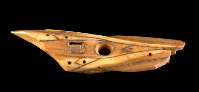
Sold2022Pre-Contact Inuit Walrus Ivory Harpoon PointNative American, North America, Pacific Northwest Coast, Alaska, St. Lawrence Island, Inuit, Punuk stage, ca. 500 to 1000 CE. A hand-carved walrus ivory harpoon point of an elongated triangular form wSee Sold Price
Sold20241775-1780 Upper Midwest and Great Lakes region. By Bonne & RaynalTitle: 1775-1780 Upper Midwest and Great Lakes region. By Bonne & Raynal Date/Period: 1775-1780 Materials: Copperplate engraved Size: 14 1/2” x 9 1/2 “ This vintage map, created by R. BonnSee Sold Price
Sold2023(NORTH AMERICA.) Group of 15 small-scale eighteenth and nineteenth century engraved maps.(NORTH AMERICA.) Group of 15 small-scale eighteenth and nineteenth century engraved maps. Vp, vd - Rigobert Bonne. Amerique Septentrionale. 10x14½ inches; hand-colored in outline. Paris, circa 17See Sold Price
Sold20241775-1780 South East Asia. Vietnam, Philippines, Thailand, Cambodia, Laos , Taiwan by Bonne & RaynalTitle: 1775-1780 South East Asia. Vietnam, Philippines, Thailand, Cambodia, Laos , Taiwan by Bonne & Raynal Date/Period: 1775-1780 Materials: Copperplate engraved Size: 14 1/2” x 9 1/2 “ TSee Sold Price
Sold20241775-1780 Southwest (Arizona, New Mexico, Texas, with most of Mexico) by Bonne & RaynalTitle: 1775-1780 Southwest (Arizona, New Mexico, Texas, with most of Mexico) by Bonne & Raynal Date/Period: 1775-1780 Materials: Copperplate engraved Size: 9 1/2? x 14 1/2? This map, dating from 1775See Sold Price
Sold20241775-1780 West Africa. Ocean currents. By Bonne & RaynalThis antique map, created by R. Bonne and Raynal between 1775 and 1780, focuses on West Africa and the coast of Guinea. It highlights ocean currents in the region. The map is part of "Histoire PhilosoSee Sold Price
Sold2021Spice island (Indonesia, Malaysia) by Bonne/Raynal 1780Title: Spice island (Indonesia, Malaysia) by Bonne/Raynal 1780 Date/Period: 1780 Materials: Copperplate engraved Size: 13 1/2 x 9 3/4'' All of modern Indonesia, Malaysia, Brunei, Singapore are shown aSee Sold Price
Sold20241775-1780 Anti Slavery Engraving. By Bonne & RaynalTitle: 1775-1780 Anti Slavery Engraving. By Bonne & Raynal Date/Period: 1775-1780 Materials: Copperplate engraved Size: 7 x 9 1/2”. This copperplate engraved map, measuring 7 x 9 1/2 inches, isSee Sold Price
Sold20241775-1780 United States and Canada. By Bonne & RaynalTitle: 1775-1780 United States and Canada. By Bonne & Raynal Date/Period: 1775-1780 Materials: Copperplate engraved Size: 14 x 10 1/2”. This antique map, created by R. Bonne and Raynal between 1See Sold Price
Sold20241775-1780 World on Mercator projection. By Bonne & RaynalTitle: 1775-1780 World on Mercator projection. By Bonne & Raynal Date/Period: 1775-1780 Materials: Copperplate engraved Size: 10” x 14 1/2” This antique map, created by R. Bonne and RaynalSee Sold Price
Sold20181786 Views of Alaska and Vancouver IslandTitle/Content of Map: 1786 Views of Alaska and Vancouver Island -- Views of the North West Coast of America explored by the Boussole & Astrolabe in 1786 (1st, 2nd and 3rd Sheets) Date Printed: 1798, LSee Sold Price
Sold2022Group of Six 18th C. Copper-Engraved MapsLot comprised of six 18th century maps: 1) Copper-engraved map, circa 1794, of North America at the end of the 18th century, with the configuration of the northwest coast and Alaska growing ever moreSee Sold Price
Sold2018Bonne: Antique Map of Louisiana and Florida, 1780Carte de la Louisiane et de la Floride Bonne's detailed map of the Mississippi basin and southeastern North America, from Florida to Virginia. Features good topographical detail, many place names andSee Sold Price
Sold2022(COLONIAL NORTH AMERICA.) Group of 3 small format 18th-century engraved maps.(COLONIAL NORTH AMERICA.) Group of 3 small format 18th-century engraved maps. London, vd - The Royal Magazine; G. Rollos, engraver. A New and Accurate Map of the Present Seat of War in North America.See Sold Price
Sold201819th C. Hawaiian Cast Iron Poi Pounder - Very RareNorth America, Hawaiian Islands, ca. 19th century CE. A sizeable and heavy cast-iron pestle meant for pounding taro root into poi. This pounder has a knob-shaped handle, a thick neck, and a pounding sSee Sold Price
Sold2018Early 20th C. Hawaiian Hardwood Tiki Totem, Two FiguresNorth America, Hawaiian Islands, ca. 1920s CE. A gorgeous tiki totem, hand-carved from hardwood and colored with natural black pigment. The totem depicts a pair of expressive Hawaiian deities, one kneSee Sold Price
Sold20231920s Hawaiian Hardwood Tiki Totem, Two FiguresNorth America, Hawaiian Islands, ca. 1920s CE. A gorgeous tiki totem, hand-carved from hardwood and colored with natural black pigment. The totem depicts a pair of expressive Hawaiian deities, one kneSee Sold Price
Sold2020Hondius' North America California an IslandHeading: Author: Hondius, Henricus Title: America Septentrionalis Place Published: Amsterdam Publisher: Date Published: 1636-[1639] Description: Copper-engraved map, lightly hanSee Sold Price
3 days LeftJasper521775-1780 North West Africa with Cape Verde and Canary Islands. By Bonne and Raynal$20
3 days LeftJasper521775-1780 North & South Carolina, Georgia and Virginia. By Bonne & Raynal$180(2 bids)
3 days LeftJasper521775-1780 South and Central America includes The Southern U.S. with Trade Winds. by Bonne & Raynal$120
3 days LeftJasper521775-1780 Uruguay, Northern Argentina, Southern Brazil, and Rio de Janeiro. By Bonne & Raynal$25(1 bid)
3 days LeftJasper521775-1780 French Guiana. Dutch Guiana and Northern Brazil. By Bonne and Raynal.$20


![Hondius' North America California an Island: Heading: Author: Hondius, Henricus Title: America Septentrionalis Place Published: Amsterdam Publisher: Date Published: 1636-[1639] Description: Copper-engraved map, lightly han](https://p1.liveauctioneers.com/642/174090/87617777_1_x.jpg?height=310&quality=70&version=1595023143)


