Sold2023Antique Map of The Holy Land, Dated 1792"Generaale Kaart Van Het Beloofde Land" colored map of The Holy Land, covering present-day Israel and Palestine, bordered by Egypt and Syria. Dated 1792, unframed. [22 x 26 inches]. Dry, losses, creasSee Sold Price
2018Mitchell: Antique Map of Palestine, 18641864 hand-colored map of Palestine by S. Augustus Mitchell. A beautiful example of S. A. Mitchell Jr.'s 1864 map of Palestine, Israel or the Holy Land. Updated from the 1860 variant with new details,See Sold Price
2018Seutter: Antique Map of Holy Land, 1740Title/Content of Map: Holy Land by Sutter Date Printed: c1740 Cartographer: Matthaus Seutter Material/Medium: Paper Size: 24" x 19 1/2" Original hand colored Copperplate engraved. Published in AugsburSee Sold Price
Sold2017von Adrichom: Antique Map of Holy Land / Naphtali, 1584Map: Tribus Neptalim Cartographer: von Adrichom Place & Date: Cologne / 1584 Size: 14 1/2" x 8 1/4" Condition: colored cartouche, town icons and topographical details; overall age toning A map of theSee Sold Price
Sold2017Stackhouse: Antique Map of Judaea / Holy Land, 1783Map: Judaea or the Holy Land Date Printed: 1783 Cartographer: Thomas Stackhouse Material/Medium: Paper Size: 16" x 20" Condition: Excellent Hand colored. Coperplate engraved. Published in London, PublSee Sold Price
Sold2023Antique German Map of the Holy LandGerman, circa 1730, hand-colored engraving on paper depicting the path of the Children of Israel after their escape from Egypt, 16 1/2" x 20 1/2" sheet size, 21" x 24 1/2" mat size.See Sold Price
Sold2017Liebaux: Antique Holy Land Tribal Map, 1767Map: Carte de la Terre Promise dressée par l'auteur du commentaire sur Josué Cartographer: Liebaux Place & Date: Paris / 1767 Size: 9" x 18 1/2" Condition: b&w folding map; backed to repair split foSee Sold Price
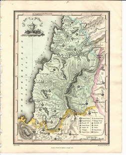
Sold2023Antique Map of Holy Land Palestine Map, Israel Twelve Tribes Jerusalem 1833 Lapie Large Folio MapAntique Holy Land Palestine Israel Twelve Tribes Jerusalem Antique 1833 Lapie Large Folio MapAntique Holy Land Palestine Israel Twelve Tribes Jerusalem 1833 Lapie Large Folio Map. Carte de la PalestinSee Sold Price
Sold2020Antique Johnson and Ward "Holy Land" MapDESCRIPTION: map of the Holy Land, based upon the 12 tribes and contemporary (to mid-19th Century) borders. Insets of view of Damascus and town plan of Jerusalem. Shows towns, roads, rivers, lakes, moSee Sold Price
Sold20151812 Hand Colored Map Holy landHandcolored map of the “Tribe of Manasseh” in the Holy land , printed by Mathews and Leigh, 1812. Measures 11 x 9”.See Sold Price
Sold20151812 Hand Colored Map of Holy landHand colored map of the “Tribe of Asher” in the Holy land , printed by Mathews and Leigh, 1812. Measures 9 x 11”.See Sold Price
Sold2017de la Rue: Antique Map of Holy Land, 1730Map: Regnum Iudeorum in Filios Herodis Magni per Tatrarchias Divisum Cartographer: Philippe de la Rue / Covens & Mortier Place & Date: Amsterdam / 1730 Size: 18 1/2" x 15 1/2" Condition: old color; ovSee Sold Price
Sold2018Le Rouge: Antique Map of Holy Land, 1746Title/Content of Map: La Palestine ou la Terre Sainte divisee en dix tribus Cartographer: le Rouge Place & Date: Paris / 1746 Size: 8 1/8" x 11" Condition: Outline color; light overall age toning andSee Sold Price
Sold2017Martier: Antique Map of Holy Land, Jerusalem, 1705Map: Ancient Holy Land Patriarchy of Jerusalem Date Printed: 1705-06 Cartographer: Pierre Martier Material/Medium: Paper Size: 23 1/2" x 19 1/2" Condition: Excellent Original hand coloring. CopperplatSee Sold Price
Sold2017Martier: Antique Map of Holy Land Divisions, 1705Map: Ancient Holy Land Divisions of the Patriarchy of Jerusalem Date Printed: 1705-06 Cartographer: Pierre Martier Material/Medium: Paper Size: 23 1/2" x 17" Condition: Excellent Original hand colorinSee Sold Price
Sold2022Impressive 1st ed. map of Palestine from J. H. Colton, 1855Detailed map of the Holy Land, colored by tribes and showing scripture names, classical names, modern names, roads, rivers, towns, villages, mountains, etc. Includes the modern-day nations of Israel,See Sold Price
Sold20161812 Handcolored Map Tribe of Manasseh Holy Land1812 Hand Colored Map of the Holy Land “The Tribe of Manasseh beyond Jordan”. Printed for Mathews and Leigh, measures 9 x 11.5”. Free shipping within the continental USSee Sold Price
Sold20181699 Bible Commentary Holy Land Maps Gospel Harmony1699 Bible Commentary Holy Land Maps Gospel Harmony Latin Bernard Lamy Bernard Lamy was a 17th-century French theologian whose book ‘Harmonia, sive Concordia’ struck controversy among many FrenchSee Sold Price
Sold20246 Decorative Old Maps of 16th-18th CenturiesSet of six vintage "Decorative Old Maps of 16th, 17th, 18th Centuries" including colored maps of Europe, The Holy Land, Asia, Belgium, and Canada and the Great Lakes. [Sheets: 16" H x 20" W]. In goodSee Sold Price
Sold2020Abraham Ortelius: Antique Map of the Holy Landwith 22 vignettes depicting the story of Abraham 16 1/4" x 20 1/4" sheetSee Sold Price
Sold2022Early 18th cent Holy Land Map of JerusalemVisscher, after Nicolaum (Nicolaes) (Dutch, 1618-1679), Die Heylige und Weitberuhmte Stadt Jerusalem Erstlich Genant Salem, antique map, c. 1710s, published in a German bible by Johann Detleffsen, a sSee Sold Price
Sold20222 PC. FRAMED ANTIQUE MAPS OF ISRAEL2 PC. FRAMED ANTIQUE MAPS OF ISRAEL: Comprising; 1- Detailed Ortelius Map of the Holy Land, Based on Tilemann Stella's Extremely Rare Holy Land Maps. 1- Homann based this map of the Holy Land on the cSee Sold Price
Sold2024Antique Map of the Holy LandLa Judee ou Terre Sainte, divisee en ses douze Tribus, map of the Holy Land printed in 1779. Engraved hand painted map, with French captions. Was printed in: Robert de Vaugondy, Gilles and Didier, AtlSee Sold Price
2 days LeftWinter Associates Three historical engraved maps of the Caribbean, ranging from 1616-1814, each hand colored, framed$100(1 bid)
4 days LeftJasper52River Thames Geometrical Landscape Altitude Map. Buildings. HAVELL 1828 (1912)$900
7 days LeftTrillium Antique Prints & Rare BooksDavid Roberts - View Under the Grand Portico, Philae$200(1 bid)
7 days LeftTrillium Antique Prints & Rare BooksDavid Roberts - General View of the Island of Philae, Nubia$200
7 days LeftTrillium Antique Prints & Rare BooksDavid Roberts - The Acropolis, Lower End of the Valley$200
5 days LeftSwann Auction Galleries(HOLY LAND.) Georg Braun; and Franz Hogenberg. Hierosolyma, Clarissima Totius Orientis Civitas,$450
BonhamsBLAEU (WILLEM AND JAN) Toonneel des Aerdrycz, oft Nieuwe Atlas... Tweede Deels, 2 parts in 1 vol...£8,000
7 days LeftTrillium Antique Prints & Rare BooksGoltzius - 6 Etchings of Portraits of Holy Roman Emperors$100
7 days LeftTrillium Antique Prints & Rare BooksBraun & Hogenberg, pub. 1575 - View of Schleswig, Germany$100
7 days LeftTrillium Antique Prints & Rare BooksBraun & Hogenberg, pub. 1575 - View of Avignon, France$100
7 days LeftTrillium Antique Prints & Rare BooksBraun & Hogenberg, pub. 1575 - View of Serravalle, Italy$100
7 days LeftTrillium Antique Prints & Rare BooksBraun & Hogenberg, pub. 1575 - Views of Brixen, Italy and Lauingen, Germany$100
7 days LeftTrillium Antique Prints & Rare BooksBraun & Hogenberg, pub. 1575 - View of Bethune, France$100
7 days LeftTrillium Antique Prints & Rare BooksBraun & Hogenberg, pub. 1575 - View of Saint-Omer, France$100
Jun 23Schilb Antiquarian Rare Books1790 Life of Jesus Christ Fleetwood Bible ART Miracles Jerusalem MAP Holy Land$80(4 bids)
3 days LeftBill Hood & Sons Art & Antique AuctionsAncient Holy Land Terracotta Cooking Pot, Israel - A terracotta pottery cooking pot with a rounded$175(2 bids)


![Antique Map of The Holy Land, Dated 1792: "Generaale Kaart Van Het Beloofde Land" colored map of The Holy Land, covering present-day Israel and Palestine, bordered by Egypt and Syria. Dated 1792, unframed. [22 x 26 inches]. Dry, losses, creas](https://p1.liveauctioneers.com/1221/303742/163342134_1_x.jpg?height=310&quality=70&version=1697564518)


![6 Decorative Old Maps of 16th-18th Centuries: Set of six vintage "Decorative Old Maps of 16th, 17th, 18th Centuries" including colored maps of Europe, The Holy Land, Asia, Belgium, and Canada and the Great Lakes. [Sheets: 16" H x 20" W]. In good](https://p1.liveauctioneers.com/1221/316726/170695118_1_x.jpg?height=310&quality=70&version=1706931805)


