Sold20241860 Minnesota and Dacotah Territory MapHand-colored map depicting Minnesota and the un-unified Dakota territories. Parts of Wisconsin and Iowa are seen in the margins. Surrounded by a border of floral vines and ribbons. Inscribed in the maSee Sold Price
Sold20171860 Minnesota and Dacotah, S. Augustus Mitchell, Jr1860 Minnesota and Dacotah, S. Augustus Mitchell, Jr. 10.625 x 13.125 inches. Engraved map with exceptionally bright original hand-coloring. This attractive, historical map depicts the new State ofSee Sold Price
Sold2023Map of Minnesota Territory by J.H. Young, 1854Map of Minnesota Territory by J.H. Young, Published by Cowperthwait, Desilver & Butler, Philadelphia, 1854. Scale 1:2,400,000 Image measures 15 1/2" x 12 1/2". Frame measures 22&quSee Sold Price
Sold2016MAP OF MINNESOTA TERRITORY BY J.H. YOUNG 1854Hand tinted lithograph map by J.H. Young, Cowperthwait, Desilver & Butler, 1854. Measures 14 x 17.2 inches overall. Depicts the Minnesota territory, lakes, rivers, forts, and native American tribal reSee Sold Price
Sold2017Young: Map of Minnesota Territory, 1850Map: Map of Minnesota Territory Maker: J. H. Young Publisher: Cowperthwait, DeSilver & Butler Publishing Date: 1850 (1854) "Important early map of Minnesota Territory, including all of Dakota, from thSee Sold Price
Sold20231859. Minnesota & Dakota territory. By Colton>Title: 1859. Minnesota & Dakota territory. By Colton Date/Period: 1859 Materials: Steel engraved Size: 17 1/2 x 14 1/2” Minnesota and Dakota territory. Important map in the settlement of the regionSee Sold Price
Sold2022Scarce 1855 Minnesota from Colton’s Atlas of the WorldImportant early atlas map of Minnesota Territory, immediately after the creation of Dakota Territory. This map appeared in the 1856 Colton 2-volume Atlas of the World. Map is by Johnson & Browning. ItSee Sold Price
Sold2017Fullarton: Antique Map of Texas & Indian Territory 1860Map: 1860 Fullarton Map of Texas (East/Central), Indian Territory, Louisiana and Arkansas -- United States North America According to Calvin Smith& Tanner . . . South Central Section. Comprising TexasSee Sold Price
Sold20231864 Johnson Map of Dakota Territory and Minnesota -- Johnson's Minnesota and DakotaTitle: 1864 Johnson Map of Dakota Territory and Minnesota -- Johnson's Minnesota and Dakota Cartographer: Johnson & Ward Year / Place: 1864, New York Map Dimension (in.): 12.5 x 15.9 in. This is a verSee Sold Price
Sold20181864 Johnson Map of Dakota Territory and MinnesotaTitle/Content of Map: 1864 Johnson Map of Dakota Territory and Minnesota -- Johnson's Minnesota and Dakota Date Printed: 1864, New York Cartographer: Johnson & Ward Size: 12.5 x 15.6 in. This is an inSee Sold Price
Sold20201861 Johnson Map of Dakota Territory and Minnesota --Title/Content of Map: 1861 Johnson Map of Dakota Territory and Minnesota -- Johnson's Minnesota and Dakota Cartographer: Johnson & Ward Year/Place: 1861, New York Size: 12.5 x 15.9 in. This is an inteSee Sold Price
Sold20241863 Johnson Map of Dakota Territory and Minnesota -- Johnson's Minnesota and DakotaDescriptionTitle: 1863 Johnson Map of Dakota Territory and Minnesota -- Johnson's Minnesota and DakotaCartographer: Johnson & WardYear / Place: 1863, New YorkMap Dimension (in.): 12.5 x 15.9 in.This iSee Sold Price
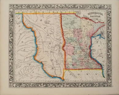
Sold20201860 Mitchell Map of Minnesota and the DakotasTitle/Content of Map: 1860 Mitchell Map of Minnesota and the Dakotas --Minnesota and Dacotah Date: 1860, Philadelphia Cartographer: S Mitchell Size: 10.6 X 13.3 in. This is a rather nice map of MinnesSee Sold Price
Sold2017UNITED STATES 1860 MAP, J.W. LOWRY, TERRITORIESFramed map of "The United States of North America (General Map)", c. 1860, "drawn and engraved by" J.W. Lowry (Joseph Wilson Lowry, British, 1803-1879), published by Blackie & Son, Glasgow, EdinburghSee Sold Price
Sold2017Mitchell: Map of the United States & Territories, 1860Map: United States & Territories Maker: Mitchell Date: 1860 Size: 13.25 x 21.25 inches Condition: Some light soil marks in margin. Nice original hand coloring. Three very tiny spots in map. Very niceSee Sold Price
Sold20181850 Meyer Mid-continent statesReserve Reduced! Scarce regional map of the upper Midwest from Meyer's Zeitungs-Atlas. Minnesota still labeled as Sioux Territory. Highly detailed map shows towns, rivers, lakes, roads, railroads, canSee Sold Price
Sold2020Minnesota territory, showing a large area of the upperTitle: Minnesota territory, showing a large area of the upper Midwestern states. RARE & important map 1850 by Thomas Date/Period: c1850 Materials: Hand colored steel engraved Size: 16 1/2 x 13 1/2 incSee Sold Price
Sold2018Tallis/Rapkin: Antique Map of the United States, 1851TITLE/CONTENT OF MAP: 'United States' The map shows 30 of the then 31 states of the United States (the other being California), plus Minnesota territory (which became the 32nd state in 1858), and NebrSee Sold Price
Sold2017Tallis/Rapkin: Antique Map of North America, 1849Title/Content of Map: 'North America' The map shows the then 30 states of the United States, plus Minnesota territory (which became the 32nd state in 1858), Nebraska Territory (eventually divided betwSee Sold Price
Sold2020Minnesota & DacotahTitle: Minnesota & Dacotah Description: By Augustus S. Mitchell. Hand colored engraved map. From ‘the New General Atlas’. Published in Philadelphia. Date/Period: 1862 Materials: steel engraved DimSee Sold Price
Sold20191847 Map Chippeway Land District Wisconsin"Provisional Geological Map of Part of the Chippeway Land District of Wisconsin with Part of Iowa & of Minnesota Territory". "To Illustrate the Report of a Geological Reconnoissance made in 1847 by DaSee Sold Price
Sold20241860 Mitchell Map of US & Territories with Canada. Inset of Pensacola Bay & Hampton Roads / NorfolkTitle/Content of Map: 1860 Mitchell Map of US & Territories with Canada. Inset of Pensacola Bay & Hampton Roads / Norfolk Harbor. Date Printed: 1860 Cartographer: S. Augustus Mitchell Material/Medium:See Sold Price
Featured3 days LeftJasper521884 Johnson Map of Washington Oregon and Idaho -- Johnson's Washington Oregon and Idaho$100
6 days LeftHolabird Western Americana CollectionsIndian Territory Map by Donaldson, 1883 [181628]$100
6 days LeftHolabird Western Americana CollectionsPyramid Lake Print Pair & 1885 NM & UT Territory Map [179398]$150
4 days LeftJasper52Africa inc. discoveries of Livingstone Barth Vogel Chadda Exp. SWANSTON 1860 map$120
3 days LeftJasper521852 Norwood Geological Map of Wisconsin and Minnesota -- Geological Map of Parts of Minnesota and$55
Featured4 days LeftJasper52Africa. Mauritius, Bourbon (Reunion) & Natal by Edward Weller 1860 old map$55
3 days LeftJasper521852 Owen Geological Maps of the Pigeon River Minnesota -- (1) Geological Map Coast View and Section$45
7 days LeftHolabird Western Americana CollectionsLafayette Gold and Silver Mining Company Stock, UT Territorial 1860 [163584]$170
6 days LeftHolabird Western Americana CollectionsSouth & Central America Map Lot c1800's [180163]$100
Jun 12Dan Morphy AuctionsPLATE CXIII. MAP OF INDIAN TERRITORY SHOWING DISTRIBUTION OF WOODLAND” FROM THE TWENTY-FIRST$100
7 days LeftTrillium Antique Prints & Rare BooksKohler & Weigel - Map of Louisiana Territory or Eastern United States (extends from New Mexico to$75(1 bid)
4 days LeftJasper52North & West Africa. Dahomey. Gold Coast. Military Territory. THE TIMES 1922 map$20


![Indian Territory Map by Donaldson, 1883 [181628] (1 of 1)](https://p1.liveauctioneers.com/2699/331495/178785757_1_x.jpg?height=282&quality=70&version=1717094933)
![Pyramid Lake Print Pair & 1885 NM & UT Territory Map [179398] (1 of 2)](https://p1.liveauctioneers.com/2699/331495/178785761_1_x.jpg?height=282&quality=70&version=1717094933)


![Lafayette Gold and Silver Mining Company Stock, UT Territorial 1860 [163584] (1 of 1)](https://p1.liveauctioneers.com/2699/331499/178846177_1_x.jpg?height=282&quality=70&version=1717095214)


![South & Central America Map Lot c1800's [180163] (1 of 5)](https://p1.liveauctioneers.com/2699/331495/178785795_1_x.jpg?height=282&quality=70&version=1717094933)


