Sold20201884 HOLY BIBLE, Clam Shell, VICTORIAN ERA, MAPS, Rare1884 HOLY BIBLE Clam Shell Victorian American Maps Leather ANTIQUE Sunday School The Holy Bible, Containing the Old and New Testaments, Etc. Great Victorian era clam shell-bound leather Bible with colSee Sold Price
Sold20201884 HOLY BIBLE Clamshell VICTORIAN American MAPS Rare1884 HOLY BIBLE Clamshell Victorian American Maps Leather ANTIQUE Sunday School The Holy Bible, Containing the Old and New Testaments, Etc. Great Victorian era clamshell-bound leather Bible with colorSee Sold Price
Sold20181718 BIBLE Dutch ENORMOUS Biblia Hasebroeck HUGE MAPS1718 BIBLE Dutch ENORMOUS Biblia Hasebroeck HUGE MAPS Brass BindingAn exceedingly rare, early 18th-century Dutch Bible published by Dordrecht. This Bible features the Old and New Testaments along withSee Sold Price
Sold20171848 Grammatica Arabica Carl Paul Caspari Arabic BIBLE1848 Grammatica Arabica Carl Paul Caspari Arabic BIBLE Grammar Language Carl Paul Caspari was a 19th-century Norwegian theologian and Old Testament professor. He is most known for his Bible interpretaSee Sold Price
Sold20191861 Family Holy BIBLE Civil War Era Old/New Testament1861 Family Holy BIBLE Civil War Era Old/New Testament English Map LARGE 3v A rare illustrated Civil War-era family Bible! Holy Bibles printed during the Civil War were printed for various purposes. MSee Sold Price
Sold20231867 Exploration in EGYPT Holy Land Sinai Ruins Pyramids Bible Archaeology MAPS1867 Exploration in EGYPT Holy Land Sinai Ruins Pyramids Bible Archaeology MAPS The Handwriting of God is a fascinating, mid-19th-century account of the Holy Land and Egypt from the Old Testament timeSee Sold Price
Sold2023Famagusta /Gazimagusa antique town city plan. Cyprus 1912 old mapTITLE/CONTENT OF MAP: 'Famagusta' DATE PRINTED: 1912 IMAGE SIZE: Approx 15.0 x 18.5cm, 6 x 7.25 inches (Medium); Please note that this is a folding map. TYPE: Antique colour tourist map CONDITION: GooSee Sold Price
Sold2024NORTH & CENTRAL ASIA. Siberia Japan Korea Khiva Bokhara Turkistan 1912 old mapTITLE/CONTENT OF MAP: 'Northern Asia; Central Asia' DATE PRINTED: 1912 IMAGE SIZE: Approx 33.0 x 44.0cm, 13 x 17.25 inches (Large); Please note that this is a folding map. TYPE: Antique colour atlas mSee Sold Price
Sold2023Grand Kremlin Palace, Moscow ground/floor plan. Russia. BAEDEKER 1912 old mapTITLE/CONTENT OF MAP: Grosser Kreml-palast,oberes stockwerk [Grand Kremlin Palace, upper floor] DATE PRINTED: 1912 IMAGE SIZE: Approx 10.0 x 15.0cm, 4 x 6 inches (Small) TYPE: Antique German languageSee Sold Price
Sold2023Antioch / Antakya antique town city plan. Turkey 1912 old map chartTITLE/CONTENT OF MAP: 'Antioch (Antakiyeh)' DATE PRINTED: 1912 IMAGE SIZE: Approx 10.0 x 15.0cm, 4 x 6 inches (Small) TYPE: Antique colour tourist map CONDITION: Good; suitable for framing. Please cheSee Sold Price
Sold2024Caucasus. Armenia, Georgia, Azerbaijan & Russian South. BAEDEKER 1912 old mapTITLE/CONTENT OF MAP: Kaukasus(Armenien/Daghestan) [Caucasus (Armenia / Georgia, Azerbaijan)] DATE PRINTED: 1912 IMAGE SIZE: Approx 15.5 x 27.5cm, 6 x 10.75 inches (Medium); Please note that this is aSee Sold Price
Sold2023Acre & environs antique town city plan. Akko. Israel. SMALL 1912 old mapTITLE/CONTENT OF MAP: 'Acre & environs' DATE PRINTED: 1912 IMAGE SIZE: Approx 8.5 x 9.0cm, 3.25 x 3.5 inches (Small) TYPE: Antique tourist map CONDITION: Good; suitable for framing. However, please noSee Sold Price
Sold2024ECUADOR PERU BOLIVIA. Border pre Guerra del 41 war. RAND MCNALLY 1912 old mapTITLE/CONTENT OF MAP: 'Ecuador, Peru and Bolivia; Inset Galapagos Islands (To Ecuador)' DATE PRINTED: 1912 IMAGE SIZE: Approx 34.0 x 27.0cm, 13.25 x 10.5 inches (Large) TYPE: Antique colour (color) atSee Sold Price
Sold2023ECUADOR PERU BOLIVIA. Border pre Guerra del 41 war. RAND MCNALLY 1912 old mapTitle: ECUADOR PERU BOLIVIA. Border pre Guerra del 41 war. RAND MCNALLY 1912 old map Description: Ecuador, Peru and Bolivia; Inset Galapagos Islands (To Ecuador)' by Rand McNally (1912). Antique colouSee Sold Price
Sold2023Tehran town/city plan. Iran. Teheran. BAEDEKER 1912 old antique map chartTITLE/CONTENT OF MAP: Teheran [Tehran] DATE PRINTED: 1912 IMAGE SIZE: Approx 15.0 x 16.0cm, 6 x 6.25 inches (Medium); Please note that this is a folding map. TYPE: Antique German language tourist mapSee Sold Price
Sold2024MEDITERRANEAN SEA. Submarine cables. Railways. JOHNSTON 1912 old antique mapCAPTION PRINTED BELOW PICTURE: 'Basin of the Mediterranean; Inset map of Maltese Islands' DATE PRINTED: 1912 IMAGE SIZE: Approx 34.0 x 43.5cm, 13.5 x 17 inches (Large); Please note that this is a foldSee Sold Price
Sold2024ASIA. Asia; Small map 1912 old antique vintage plan chartTITLE/CONTENT OF MAP: 'Asia' DATE PRINTED: 1912 IMAGE SIZE: Approx 10.5 x 14.0cm, 4.25 x 5.5 inches (Small) TYPE: Colour vintage map CONDITION: Good; suitable for framing. Please check the scan for anSee Sold Price
Sold20211867 RARE Holy BIBLE Old & New Testaments HUGE Binding1867 RARE Holy BIBLE Old & New Testaments HUGE Binding Clasps Harding An incredible 19th-century Holy Bible filled with beautiful woodcut engravings! This 1867 edition is bound in fine, decorative leaSee Sold Price
Sold20221867 RARE Holy BIBLE Old & New Testaments HUGE Binding Clasps Harding1867 RARE Holy BIBLE Old & New Testaments HUGE Binding Clasps Harding An incredible 19th-century Holy Bible filled with beautiful woodcut engravings! This 1867 edition is bound in fine, decorative leaSee Sold Price
Sold2021Rare Old Two Volumes Bible, 1779"La sainte Bible", qui contient le Vieux et le Nouveau Testament / revue & corrig?e sur le texte h?breu & grec, par les pasteurs & les professeurs de l'Eglise de Gen?ve ; avec les argumens [i.e. argumSee Sold Price
Sold20201846 Holy Bible, Old and New Testament, 14 Maps, Charts1846 Beautiful Holy Bible, Old and New Testament, 14 Maps, Charts Illustrated with 14 Colored Maps and Folding Chart. Containing the Old and New Testaments, with The Parallel Passages and ExplanatorySee Sold Price
Sold20201846 Holy Bible, Old and New Testament, 14 Maps, Charts1846 Holy Bible, Old and New Testament, 14 Maps, Charts Illustrated with 14 Colored Maps and Folding Chart.Containing the Old and New Testaments, with The Parallel Passages and Explanatory Notes.LondoSee Sold Price
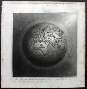
Sold2019Rhind, William 1844 Rare Map of the Old World. EarthAquatint Map Published 1844, London "The Creation: Illustrated By Six Engravings On Steel" by William Graeme Rhind. Rare. Paper Size: 6.5 x 6 inch (16.5 x 16cm) Very minor margin toning, slightly affeSee Sold Price
Sold20181868 BEAUTIFUL King James Holy BIBLE American Bible1868 BEAUTIFUL King James Holy BIBLE American Bible Society Old & New Testament A rare 19th-century family Holy Bible published by the American Bible Society in 1868. Decorative page edges with embossSee Sold Price
4 days LeftJasper52Fusan (Busan) harbour, South Korea. ADMIRALTY sea chart 1912 (1955) old map$360(1 bid)
Jul 14Schilb Antiquarian Rare Books1840 BIBLE of Old Master ART Paintings Da Vinci Rembrandt Poussin Rubens 4v$32(2 bids)
Jul 14Schilb Antiquarian Rare Books1836 Early AMERICAN Holy Bible Concord New Hampshire Moroccan Leather Sanborn$1(1 bid)


![Grand Kremlin Palace, Moscow ground/floor plan. Russia. BAEDEKER 1912 old map: TITLE/CONTENT OF MAP: Grosser Kreml-palast,oberes stockwerk [Grand Kremlin Palace, upper floor] DATE PRINTED: 1912 IMAGE SIZE: Approx 10.0 x 15.0cm, 4 x 6 inches (Small) TYPE: Antique German language](https://p1.liveauctioneers.com/5584/278338/146429492_1_x.jpg?height=310&quality=70&version=1676415582)

![Caucasus. Armenia, Georgia, Azerbaijan & Russian South. BAEDEKER 1912 old map: TITLE/CONTENT OF MAP: Kaukasus(Armenien/Daghestan) [Caucasus (Armenia / Georgia, Azerbaijan)] DATE PRINTED: 1912 IMAGE SIZE: Approx 15.5 x 27.5cm, 6 x 10.75 inches (Medium); Please note that this is a](https://p1.liveauctioneers.com/5584/317307/170365537_1_x.jpg?height=310&quality=70&version=1706652332)


![Tehran town/city plan. Iran. Teheran. BAEDEKER 1912 old antique map chart: TITLE/CONTENT OF MAP: Teheran [Tehran] DATE PRINTED: 1912 IMAGE SIZE: Approx 15.0 x 16.0cm, 6 x 6.25 inches (Medium); Please note that this is a folding map. TYPE: Antique German language tourist map](https://p1.liveauctioneers.com/5584/278338/146429650_1_x.jpg?height=310&quality=70&version=1676415582)


![[Geneva Bible] (1 of 1)](https://p1.liveauctioneers.com/94/330664/178342142_1_x.jpg?height=282&quality=70&version=1716466933)


