Sold20241866 FRAMED MAP OF PRUSSIA GERMANYJOHNSON'S NEW YORK, HAND COLORED MAP, DATED 1866. LOOSE IN FRAME. 26" X 32" IN FRAMESee Sold Price
Sold2019Three Maps by A. J. Johnson, consisting of "NewThree Maps by A. J. Johnson, consisting of "New Brunswick, Nova Scotia, Newfoundland, and Prince Edward Island," 1860-1863, hand colored, H.- 13 3/8 in., W.- 17 in.; "Prussia and Germany," 1866, handSee Sold Price
Sold2023Set 4 19th Century Johnson & Ward Color Maps Germany Mexico Switzerland & Central AmericaSet 4 19th Century Johnson & Ward Color Maps Germany Mexico Switzerland & Central America. Measurements in inches: 18 x 14 Condition:Has toning and tear to edges Shipping:We offer in-house shipping. ISee Sold Price
Sold202319th century. A hand-colored United States published map of Germany. Published by Johnson and Ward,19th century. A hand-colored United States published map of Germany. Published by Johnson and Ward, New York USA. Marked as page 85. Overall good condition; some toning throughout and dark spot in botSee Sold Price
Sold2023Johnson & Exley 1812 Antique Map. GermanyCopper Engraved Map Published 1812, London for "The Imperial Encyclopaedia; Or, Dictionary of the Sciences and Arts" by William Moore Johnson & Thomas Exley. Paper Size: 10.5 x 8.5 inch (27 x 22cm) WaSee Sold Price
Sold2016Empire of Germany by Johnson 1868Map Title: Empire of Germany Maker: Johnson Date: 1868 Publisher: Alvin J. Johnson & Co.: New York Size: 18 x 26 inches From Johnson's Atlas of the World Map includes vignette of Prussia and details cSee Sold Price
Sold20211861 Map of GermanyAuthor: Johnson Title: 1861 Map of Germany Medium: Ink on Paper Dimensions: 18"X13.5" Map of Germany dated 1861. Engraved by A.J. Johnson dated 1861. Published by Johnson and Ward in New York. CaptureSee Sold Price
SoldMammoth Cave Sign & Other EphemeraMammoth Cave Sign & Other Ephemera- Johnson Wax tri-fold postcard, Road Map of Germany, 1945 Pathfinder magazines, Early 1900's Business Logo envelopes F Emmert Brewing Company of St. Paul, Minn. 2 LaSee Sold Price
Sold2019Germany. Part 2,3, western area and south.Title/Content of Map: Germany. Part 2,3, western area and south. Date: 1863 Cartographer: By Johnson & Ward. From, Johnson’s New Illustrated Family Atlas Size: 18x26 1/2” Provenance: New York AddiSee Sold Price
Sold2019Germany (1) north and east.Title/Content of Map: Germany (1) north and east. Date: 1863 Cartographer: By Johnson & Ward. From, Johnson’s New Illustrated Family Atlas Size: 18 x 13 3/4” Provenance: New York Additional Info:See Sold Price
Sold2017Map of GermanyColton's Germany (1 of 3) published by Johnson & Browning 1860 Size: 17.5 x 14.75 Please note that this lot has a confidential reserve. When you leave a bid in advance of the auction, submit your maxiSee Sold Price
Sold20231866 Johnson Map of Nebraska, Dakotas, Idaho, Montana and Wyoming-- Johnson's Nebraska, Dakota,Title: 1866 Johnson Map of Nebraska, Dakotas, Idaho, Montana and Wyoming-- Johnson's Nebraska, Dakota, Idaho and Montana Cartographer: Johnson & Ward Year / Place: 1866, New York Map Dimension (in.):See Sold Price
Sold20231866 Johnson Map of the United States -- Johnson's United StatesTitle: 1866 Johnson Map of the United States -- Johnson's United States Cartographer: Johnson and Ward Year / Place: 1865, New York Map Dimension (in.): 17 X 23.2 in. This is a superb double-page mapSee Sold Price
Sold2016Rare 1866 Johnson's Map of New York and Brooklyn FrameVery rare 1866 map of Manhattan and Brooklyn in 1866. Johnson & Ward, makers. Hand-colored. Professionally matted and framed. Approx 35" x 27". In excellent condition.See Sold Price
Sold20231866 Johnson Map of Japan -- Johnson's Japan Nippon, Kiusiu, Sikok, Yesso and the Japanese KurilesTitle: 1866 Johnson Map of Japan -- Johnson's Japan Nippon, Kiusiu, Sikok, Yesso and the Japanese Kuriles Cartographer: Johnson & Ward Year / Place: 1866, New York Map Dimension (in.): 13 X 15.5 in. TSee Sold Price
Sold20241866 Johnson's Map of Hungary, Austria, Greece and Turkey in Europe -- Johnson's Austria, Turkey inTitle: 1866 Johnson's Map of Hungary, Austria, Greece and Turkey in Europe -- Johnson's Austria, Turkey in Europe and Greece Cartographer: Johnson & Ward Year / Place: 1866, New York Map Dimension (inSee Sold Price
Sold20231866 Johnson Map of Palestine / Holy land -- Johnson's PalestineTitle: 1866 Johnson Map of Palestine / Holy land -- Johnson's Palestine Cartographer: Johnson & Ward Year / Place: 1866, New York Map Dimension (in.): 15.6 X 12.6 in. This is an attractive map of PaleSee Sold Price
Sold20231866 Johnson Map of Washington, Oregon Minnesota -- Johnson's Oregon and Washington [on sheet with]Title: 1866 Johnson Map of Washington, Oregon Minnesota -- Johnson's Oregon and Washington [on sheet with] Johnson's Minnesota Cartographer: Johnson & Ward Year / Place: 1866, New York Map Dimension (See Sold Price
Sold20221866 Johnson's Map of Italy -- Johnson's ItalyTitle: 1866 Johnson's Map of Italy -- Johnson's Italy Cartographer: Johnson & Ward Year / Place: 1866, New York Map Dimension (in.): 22.5 X 15.7 in This is a superb double-page map of Italy. Inset isSee Sold Price
Sold20221866 Johnson Map of Africa -- Johnson's AfricaTitle: 1866 Johnson Map of Africa -- Johnson's Africa Cartographer: Johnson & Ward Year / Place: 1866, New York Map Dimension (in.): 23 X 17.3 in. This a superb double-page map of Africa. Large insetsSee Sold Price
Sold20211866 Johnson Map of Arkansas, Mississippi and LouisianaTitle: 1866 Johnson Map of Arkansas, Mississippi and Louisiana -- Johnson's Arkansas, Mississippi and Louisiana Cartographer: A J Johnson Year / Place: 1866, New York Map Dimension (in.): 17 X 24 in.See Sold Price
Sold20241866 Johnson Map of Central America -- Johnson's Central AmericaTitle: 1866 Johnson Map of Central America -- Johnson's Central America Cartographer: Johnson and Ward Year / Place: 1866, New York Map Dimension (in.): 12.5 X 15.6 in. This is an excellent map of CenSee Sold Price
Sold20221866 Johnson Map of Massachusetts, Connecticut and Rhode Island -- Johnson's Massachusetts,Title: 1866 Johnson Map of Massachusetts, Connecticut and Rhode Island -- Johnson's Massachusetts, Connecticut and Rhode Island Cartographer: Johnson and Ward Year/Place: 1866, New York Dimensions: 17See Sold Price
Sold20221866 Johnson's Map of Illinois -- Johnson's IllinoisTitle: 1866 Johnson's Map of Illinois -- Johnson's Illinois Cartographer: Johnson & Ward Year / Place: 1866, New York Map Dimension (in.): 22.5 X 17 in. This is an excellent double page map of IllinoiSee Sold Price
4 days LeftJasper52Johnson's California with Utah, Nevada, Colorado, New Mexico & Arizona 1866 map$440
144 Lots AwaySimpson Galleries, LLC.AN AMERICAN CIVIL WAR ERA ATLAS, "Johnson's New Illustrated Family Atlas of the World with Physical$300
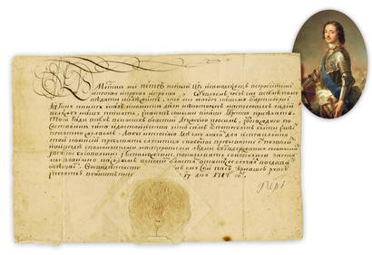
Jun 26University ArchivesPeter the Great 1717 DS Recruiting German Craftsmen, Notably Shipbuilders, Fascinating and Stunning!$4,000
Jun 23Leonard Auction, a division of The Leonard CompanyKarl Rohrhirsch (German, 1875-1954) Oil on Board$150
3 days LeftJasper521863 Johnson Map of the World Illustrating the Animal Kingdom and Productive Industry$55
3 days LeftJasper521863 Johnson Map of the World Illustrating Land, Co-tidal Lines and Ocean Currents and River Systems$45
3 days LeftJasper521552 Munster Regional German Map Centered on Bamberg -- Franconia XIII Nova Tabula$95


![1866 Johnson Map of Washington, Oregon Minnesota -- Johnson's Oregon and Washington [on sheet with]: Title: 1866 Johnson Map of Washington, Oregon Minnesota -- Johnson's Oregon and Washington [on sheet with] Johnson's Minnesota Cartographer: Johnson & Ward Year / Place: 1866, New York Map Dimension (](https://p1.liveauctioneers.com/5584/300803/160206896_1_x.jpg?height=310&quality=70&version=1693946338)