Sold2024Vintage Texas 1845 Map Printed in 1986, Compiled by John DavisVintage Texas 1845 Map Printed in 1986, Compiled by John Davis and signed by him on 1992. 32 1/4 x 26 1/4 x 3/4 in.Local Pick up call one day before to make an appointment. TO SHIP THIS ITEM IN USA ORSee Sold Price
Sold2020FRAMED RANGER CANYON PRESS TEXAS WAGON TRAIL MAPFramed Texas Wagon Trail map, c.1986, signed John Davis (John Edward Davis, Texas, 1951-2008), published by Ranger Canyon Press, sight: approx 30.5"h, 25.5"w, overall: approx 32.75"h, 27.75"w, 8lbs StSee Sold Price
Sold2022after JOHN ARROWSMITH (1790-1873) A REPUBLIC OF TEXASafter JOHN ARROWSMITH (1790-1873) A REPUBLIC OF TEXAS ERA MAP, "Texas.," GLOGAU, 1845/1846, lithograph in colors, by Silesian cartographer C. Flemming (fl. 1840-1879), printed in German, sheet: 17 1/2See Sold Price
Sold20221756 Fine English Leather Science AstronomyThe Philosophical Transactions (From the Year 1743 to the Year 1750) Abridged…, compiled by John Martyn, printed at London by Lockyer Davis, MDCCLVI (1756). Full and General Title, Contents, 797See Sold Price
Sold2024Map of Mexico (California & Texas) by John Tallis, 1851Title/Content of Map: Map of Mexico (California & Texas) by John Tallis, 1851 Date Printed: 1851 Cartographer: John Tallis Material/Medium: Engraving Size: 11 x 14" John Tallis was a British map publiSee Sold Price
Sold20221846 Vintage New Map of Texas Oregon and California1846 A New Map of Texas Oregon and California A New Map of Texas Oregon and California With The Regions Adjoining. Compiled from the most recent authorities. Philadelphia Published by S. Augustus MitSee Sold Price
Sold2020Texas, Indian Terratory 1888Title/Content of Map: Texas, Indian Terratory 1888 Date Printed: 1888 Material/Medium: paper Size: approx 11x14 inches Additional Info: John C. Lonngren & Son Standard Atlas of the World Reserve: $20See Sold Price
Sold2017Vintage Paper W Canvas Map of Suffolk CoVintage Paper W Canvas Map of Suffolk Co. Reads as the 'Map of Suffolk. Co. L.I. New York." Also reads published by John a Douglas. Some stains on canvas and wear to paper. Printed Paper map mounted oSee Sold Price
Sold2023NORTH AMERICA. Texas Republic. Mexican California. Russian America SDUK 1851 mapTITLE/CONTENT OF MAP: 'NORTH AMERICA' The borders printed on the map reflect national boundaries as they existed between 1836 and 1845 during which period the map was engraved, including the RepublicSee Sold Price
Sold2017Johnston: Antique Map of North America, 1845Map: North America. Texas Republic in Largest Format Publication Date: 1845 Authors: JOHN JOHNSTONE AND W. & A.K. JOHNSTON, JOHNSTON, A. K. Publisher: JOHN JOHNSTONE AND W. & A.K. JOHNSTON Size: FolioSee Sold Price
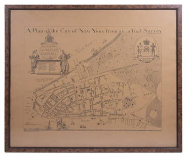
Sold2023REPLICA OF LAING'S MAP OF MANHATTAN"A Plan of the City of New York from an actual Survey" for His Excellency John Montgomerie, by William Bradford, printed on tan paper, in a faux tortoiseshell frame, under glass, 23" x 26", good condiSee Sold Price
Sold2021A TREATISE OF ALGEBRA, JOHN WALLIS (1685).A Treatise of Algebra, both Historical and Practical by John Wallis. Printed by John Playford, for Richard Davis, Bookseller, in the University of Oxford, 1685 folio. John Wallis was a famous 17th cenSee Sold Price
Sold2021HELMUT NEWTON - Two Playmates, Hollywood - OriginalArtist: Helmut Newton (German/Australian, 1920-2004). Title: "Two Playmates, Hollywood". Medium: Original vintage photolithograph. Date: Composed 1986. Printed 1987. Dimensions: Image size: 1See Sold Price
Sold2022HELMUT NEWTON - Hollywood Hills - Original vintage photolithographArtist: Helmut Newton (German/Australian, 1920-2004). Title: "Hollywood Hills". Medium: Original vintage photolithograph. Date: Composed 1986. Printed 1987. Dimensions: Image size: 14 7/8 x 1See Sold Price
Sold2022HELMUT NEWTON - Two Playmates, Hollywood - Original vintage photolithographArtist: Helmut Newton (German/Australian, 1920-2004). Title: "Two Playmates, Hollywood". Medium: Original vintage photolithograph. Date: Composed 1986. Printed 1987. Dimensions: Image size: 1See Sold Price
Sold2021HELMUT NEWTON - Hollywood Hills - Original vintageArtist: Helmut Newton (German/Australian, 1920-2004). Title: "Hollywood Hills". Medium: Original vintage photolithograph. Date: Composed 1986. Printed 1987. Dimensions: Image size: 14 7/8 x 1See Sold Price
Sold2021HELMUT NEWTON - Two Playmates, Hollywood - OriginalArtist: Helmut Newton (German/Australian, 1920-2004). Title: "Two Playmates, Hollywood". Medium: Original vintage photolithograph. Date: Composed 1986. Printed 1987. Dimensions: Image size: 1See Sold Price
Sold2021HELMUT NEWTON - Hollywood Hills - Original vintageArtist: Helmut Newton (German/Australian, 1920-2004). Title: "Hollywood Hills". Medium: Original vintage photolithograph. Date: Composed 1986. Printed 1987. Dimensions: Image size: 14 7/8 x 1See Sold Price
Sold2016Tatum Davis archive, Texas c. 1850sA group of about 70 letters from 1828-1850s related to Howell Tatum Davis (b .1813-d. 1861, brother of John Davis, son of Frederick Davis, who moved to Texas circa 1840s). The letters are addressed toSee Sold Price
Sold2017EDWARD ST. JOHN GOREY (American 1925-2000) A GROUP OFEDWARD ST. JOHN GOREY (American 1925-2000) A GROUP OF NINE PRINTS, "Elefantomas," PUBLISHED 1986, printed on Arches Cover paper, numbered in pencil R1-R9 L/L and signed in pencil L/R. With original haSee Sold Price
Sold2023MITCHELL'S NEW MAP of TEXAS, OREGON & CALIFORNIA1846 Philadelphia, S. Augustus Mitchell. hardcover leather bound. 5 1/4 x 3 1/4 inches. Map unfolded 22 x 20 1/2 inches and presented in a custom frame 23 1/2 x 22 inches (overall)See Sold Price
Sold2022(UNITED STATES - REPUBLIC OF TEXAS.) James Wyld. Map of the United States and the Provinces of Upper(UNITED STATES - REPUBLIC OF TEXAS.) James Wyld. Map of the United States and the Provinces of Upper & Lower Canada, New Brunswick, and Nova Scotia, Compiled from the Latest Surveys and Other AuthentiSee Sold Price
Sold2022[MAPS]. MELISH, John (1771-1821). United States of America Compiled form the latest & bet[MAPS]. MELISH, John (1771-1821). United States of America Compiled form the latest & bet Authorities. Philadelphia: Murray Draper Fairman & Co., 1818. Engraved map of the eastern United States,See Sold Price
Sold2020John Biggers (1924-2001) - Brown Family (Family of Six)John Biggers 1924-2001 Brown Family (Family of Six) Lithograph printed in brown on cream wove paper 1986 signed, titled, dated, and numbered 27/50. Provenance: The collection of Faith Grobman, NJ.See Sold Price
4 days LeftSwann Auction Galleries(WORLD.) Henry Teesdale; and John Dower (engraver). A New Chart of the World$1,500
152 Lots AwayBritannica Auctions LtdNuttall's Hare - Rare Imperial Folio by JW Audubon 1846£360(1 bid)
3 days LeftDan Morphy AuctionsBRUE'S MONUMENTAL WALL MAP OF TEXAS, UPPER CALIFORNIA & MEXICO, C. 1845$500(1 bid)
4 days LeftJasper52Darbieshire. Derbyshire county map by John Speed. Bassett/Chiswell edition 1676$440
4 days LeftJasper52Bohemia Newly described by John Speed… 1626. Bassett/Chiswell edition 1676 map$1,100
BonhamsBUTLER (CHARLES) The Feminine Monarchie: or The Historie of Bees, Printed by John Haviland for R...£500
286 Lots AwayBritannica Auctions LtdDaffodils, Violets, Primroses & Oxlip by JE Giraud 1845£10(1 bid)
BonhamsDICKENS (CHARLES) [Christmas Books] A Christmas Carol. In Prose. Being a Ghost Story of Christma...£600(1 bid)


![[MAPS]. MELISH, John (1771-1821). United States of America Compiled form the latest & bet: [MAPS]. MELISH, John (1771-1821). United States of America Compiled form the latest & bet Authorities. Philadelphia: Murray Draper Fairman & Co., 1818. Engraved map of the eastern United States,](https://p1.liveauctioneers.com/197/265300/138516600_1_x.jpg?height=310&quality=70&version=1666052782)


![DICKENS (CHARLES) [Christmas Books] A Christmas Carol. In Prose. Being a Ghost Story of Christma... (1 of 2)](https://p1.liveauctioneers.com/1043/319451/178359159_1_x.jpg?height=282&quality=70&version=1717776927)
