Sold20241851 Tallis Map of Tartary -- Part of Russia in Asia, and Independent TartaryTitle: 1851 Tallis Map of Tartary -- Part of Russia in Asia, and Independent Tartary Cartographer: J Tallis Year / Place: 1851 c., London Map Dimension (in.): 10 X 13 in. This is a rarely seen TallisSee Sold Price
Sold2024CENTRAL ASIA. Karasm [Khwarezm] Great Bochara [Bukhara] Usbeck Tartary 1746 mapTITLE/CONTENT OF MAP: 'A Map of Karasm & Great Bochara or Usbeck-Tartary; Drawn from those of Danville, Kyrillow & c. with improvements' The map shows part of Central Asia including the Caspian and ArSee Sold Price
Sold20231730 Bowen Map of China with Marco Polo's Travel Path -- A Map of Marco Polo's Voyages & Travels inTitle: 1730 Bowen Map of China with Marco Polo's Travel Path -- A Map of Marco Polo's Voyages & Travels in the 13th Century Through a Great Part of Asia, All Tartary, the East India Islands & Part ofSee Sold Price
Sold2021Map showing Marco Polo's travelsHeading: Author: Bowen, Emanuel Title: A Map of Marco Polo's Voyages & Travels in the 13th Century Through a Great Part of Asia, All Tartary, the East India Islands & Part of Africa Place Published:See Sold Price
Sold2024La Gran Tartaria. Great Tartary. Central/North Asia. ROSSI / CANTELLI 1683 mapTitle: La Gran Tartaria. Great Tartary. Central/North Asia. ROSSI / CANTELLI 1683 map Description: La Gran Tartaria divisa nelle sue parti principali [Great Tartary divided into its main parts] by PubSee Sold Price
Sold2020Nicolas Sanson Map of AsiaNicolas Sanson (1600-1667) "L'Asie divisee en ses Principales Regions, et ou se peuvent voir l'estendue, Des Empires, Monarchies, Royaumes, et Estats," Paris: Jaillot, ca. 1719. Hand colored map of AsSee Sold Price
Sold2024Nicolas Sanson - Map of Asia / Asia divided into its Principal RegionsCopper engraving, 1600s/1700s, "Asia divided into its Principal Regions." By Mr. Sanson, Geographer Ordinary to the King. Size: 58 cm x 88 cm.See Sold Price
Sold2022Alexis Hubert Jaillot and Nicolas Sanson - Map of the Grand Duchy of Moscow, Etching, 1708.Alexis Hubert Jaillot (French, 1632-1712) and Nicolas Sanson (French, 1600-1667) - Map of the White Russia or the Grand Duchy of Moscow, Etching, 1708. Title: Les Estats du Czaar de Russie Blanche ouSee Sold Price
Sold2023Sanson map of ancient Asia 1650Heading: Author: Sanson, Nicolas Title: Asia Vetus Place Published: Paris Publisher: Date Published: [1650] Description: Copper-engraved map, hand-colored in outline; colored decorSee Sold Price
Sold2017T Cowperthwait: Russia In Asia & Tartary MapRussia in Asia and Tartary, 17 x 13.5 in, 1850, Thomas Cowperthwait Please note that this lot has a confidential reserve. When you leave a bid in advance of the auction, submit your maximum. Jasper52See Sold Price
Sold20181732 Moll Map of Tartary and Central Asia -- GreatTitle/Content of Map: 1732 Moll Map of Tartary and Central Asia -- Great Tartary. With the Tract of the Moscovite Ambassador's Travels from Moscow to Pekin in China… Date Printed: 1732, London CartoSee Sold Price
Sold2022Bellin: Two Maps of Tartary: Northeast & Central AsiaTitle/Content of Map: Bellin: Two Maps of Tartary: Northeast & Central Asia Date Printed: 1749/1760, Paris Cartographer: Bellin Size: 12" x 8 1/2" (each) Bellin's highly detailed maps of Eastern and WSee Sold Price
Sold2018Sanson/Covens & Mortier: Eastern Holy Land, 1730The later Covens & Mortier edition of Sanson's map of the eastern part of the land of Canaan "now Palestine," derived from von Adrichom's Holy Land map (Situs Terrae Promissionis). Oriented with the wSee Sold Price
Sold20241683 Map Of The Great Tartary Northern/Central AsiaBy Giovanni Giacomo and Giovanni Cantelli, Site 18.75" x 23"See Sold Price
Sold2018Map of the Southeast Part of AsiaTitle/Content of Map: Map of the Southeast Part of Asia Date Printed: 1790 ca. Cartographer: PTOLEMY Size: 12x20.3 "according to Ptolemy for illustrating Dr. Robertson's historical disquisition &c." MSee Sold Price
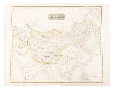
Sold2019Map of Tartary comprising most of AsiaHeading: (Maps) Author: Thomson, John Title: Tartary Place Published: Edinburgh Publisher: Date Published: 1814 Description: Engraved map, hand-colored in outline. 49.8x59.5See Sold Price
Sold2015Map of Greece and part of Asia Minor. Print in 1850.Print of steel engraving titled „La Grece et partie de l‘Asie Mineure“.Author A. Houze.Engraved by unknown.From the „Atlas Universel Historique et Geographique“ by A. Houze, Paris. 1850.GreeSee Sold Price
Sold2018Ancient Greece, Including Parts of Asia Minor, 1820Title/Content of Map: Ancient Greece, Including Parts of Asia Minor. Epirus, Macedonia, Thrace, Illyria, Moesia, Pannonia and Dacia. Date Printed: 1820 Cartographer: GROS, C. Size (inches): 13x12.6 "FSee Sold Price
Sold2018Map of the South West Part of Asia, 1821Title/Content of Map: Map of the South West Part of Asia Cartographer: MUTLOW, H. Size: 10X16.25 "for illustrating Dr. Robertson's historical disquisition &c." Centers on India. Shows Arabia and BurmaSee Sold Price
Sold2017Mitchell Cowperthwait: Map of Russia in Asia & TartaryTitle: Map of Russia in Asia and Tartary By Mitchell, Thomas, and Cowperthwait Date: 1851 Dimensions: 17 x 14 Medium: Hand Colored Lithograph Please note that this lot has a confidential reserve. WhenSee Sold Price
Sold2017Antique Map of India, 1812Early 1812 Antique "Map of the SOUTH EAST part of ASIA for illustrating Dr. Robertson's Historical Disquisition &c."; as found and removed from the book, "An Historical Disquisition concerning the knoSee Sold Price
Sold2022(TRAVEL -- ASIA.) John Bell. Travels From St. Petersburg in Russia to Diverse Parts of Asia.(TRAVEL -- ASIA.) John Bell. Travels From St. Petersburg in Russia to Diverse Parts of Asia. Engraved folding map showing the route from Moscow to Beijing with a decorative inset of the Chinese capitaSee Sold Price
Sold20191870 Knox Voyages to ASIA Siberia China Tartary1870 Knox Voyages to ASIA Siberia China Tartary Illustrated Mongolia MAPS Russia Thomas Wallace Knox was a 19th-century traveler known for his writings on his voyages. This 1871 printing of ‘OverlanSee Sold Price
Sold2024Tartaria by Bertius / Langenes. Tartary. Asia. Great Wall of China 1603 mapCAPTION PRINTED BELOW PICTURE: Descriptio Tartariae / Tartaria [Tartary] The map depicts the Great Wall of China DATE PRINTED: 1603 IMAGE SIZE: Approx 10.5 x 17.0cm, 4.25 x 6.5 inches (Small) TYPE: AnSee Sold Price
2 days LeftJasper521755 MAP of RUSSIAN EMPRIRE & INNER ASIA CHINESE TARTARY antique 20 x 27 in.$100(1 bid)
6 days LeftTrillium Antique Prints & Rare BooksCluver & De L'Isle - Map of the Eastern Hemisphere (Europe, Asia, Africa and part of Australia)$75
6 days LeftLeon GalleryGiovanni Battista Ramusio (1485 - 1557) Giacomo Gastaldi (1500 - 1566) - Terza Ostro Tavola (The₱1,300,000
6 days LeftTrillium Antique Prints & Rare BooksSanson - Map of California as an Island, Mexico (Audience de Guadalajara)$90(4 bids)
6 days LeftTrillium Antique Prints & Rare BooksSanson - Map of North America with California as an Island$85(2 bids)
6 days LeftTrillium Antique Prints & Rare BooksSanson - Map of Moluccas, Celebes, & Gilolo (Halmahera)$75
BonhamsBLAEU (WILLEM AND JAN) Toonneel des Aerdrycz, oft Nieuwe Atlas... Tweede Deels, 2 parts in 1 vol...£8,000
BonhamsCHAPLIN (CHARLIE) Playbill for 'Sherlock Holmes', Wolverhampton, Whitehead Bros, Theatrical Prin...£500
Crawford Family Auctions LLCFramed print of Map of Part of the Island of Hawaii & Sandwich Islands, w/COA$20


![CENTRAL ASIA. Karasm [Khwarezm] Great Bochara [Bukhara] Usbeck Tartary 1746 map: TITLE/CONTENT OF MAP: 'A Map of Karasm & Great Bochara or Usbeck-Tartary; Drawn from those of Danville, Kyrillow & c. with improvements' The map shows part of Central Asia including the Caspian and Ar](https://p1.liveauctioneers.com/5584/329387/177649411_1_x.jpg?height=310&quality=70&version=1715717898)


![La Gran Tartaria. Great Tartary. Central/North Asia. ROSSI / CANTELLI 1683 map: Title: La Gran Tartaria. Great Tartary. Central/North Asia. ROSSI / CANTELLI 1683 map Description: La Gran Tartaria divisa nelle sue parti principali [Great Tartary divided into its main parts] by Pub](https://p1.liveauctioneers.com/5584/314775/168780611_1_x.jpg?height=310&quality=70&version=1704837726)


![Sanson map of ancient Asia 1650: Heading: Author: Sanson, Nicolas Title: Asia Vetus Place Published: Paris Publisher: Date Published: [1650] Description: Copper-engraved map, hand-colored in outline; colored decor](https://p1.liveauctioneers.com/642/310901/166355383_1_x.jpg?height=310&quality=70&version=1701367957)


![Tartaria by Bertius / Langenes. Tartary. Asia. Great Wall of China 1603 map: CAPTION PRINTED BELOW PICTURE: Descriptio Tartariae / Tartaria [Tartary] The map depicts the Great Wall of China DATE PRINTED: 1603 IMAGE SIZE: Approx 10.5 x 17.0cm, 4.25 x 6.5 inches (Small) TYPE: An](https://p1.liveauctioneers.com/5584/329387/177649214_1_x.jpg?height=310&quality=70&version=1715717898)


