Sold2020[JAPAN]. A lot of 3 maps sold together[JAPAN]. A lot of 3 maps sold together. Engravings on paper, generally fine. Including: Guillaume Sanson. DE EILANDEN VAN JAPAN. 8.5 x 24cm. [1705] ** Jacques Nicolas Bellin. CARTE DES ÃŽLES DU JAPOSee Sold Price
Sold2022MAP, Japan & Korea, MercatorHondius' Richly Ornamented Map of Japan. Japan & Korea. Mercator/Hondius, Iaponia, from Gerardi Mercatoris - Atlas sive Cosmographicae, 1634 (published). Hand Color. Superb map of Japan based on the OSee Sold Price
Sold2022MAP, Japan & Korea, JanssonJapan & Korea. Jan Jansson, Nova et Accurata Iaponiae, Terrae Esonis, ac Insularum Adjacentium. Ex Novissima Detectione Descriptio, from Atlas Contractus, 1666 (circa). Hand Color. This superb folio mSee Sold Price
Sold20181683 Sanson Map of the Great Lakes and the Upper EastTitle/Content of Map: 1683 Sanson Map of the Great Lakes and the Upper East Coast -- Le Canada, ou Nouvelle France, &c. Tiree de diverses Relations des Francois, Anglois, Hollandois, &c. Date: 1683, PSee Sold Price
Sold20211683 Sanson Map Great Lakes to Newfoundland -- LeTitle: 1683 Sanson Map Great Lakes to Newfoundland -- Le Canada, ou Nouvelle France, &c. Tiree de diverses Relations des Francois, Anglois, Hollandois, &c. Cartographer: N Sanson Year / Place: 1683 c.See Sold Price
Sold20181683 Sanson Map of the Great Lakes and the Upper EastTitle/Content of Map: 1683 Sanson Map of the Great Lakes and the Upper East Coast -- Le Canada, ou Nouvelle France, &c. Tiree de diverses Relations des Francois, Anglois, Hollandois, &c. Date Printed:See Sold Price
Sold20231652 Sanson Map of the World -- L'Hydrographie ou Descriprion de L'Eau c'est a dire des Mers,Title: 1652 Sanson Map of the World -- L'Hydrographie ou Descriprion de L'Eau c'est a dire des Mers, Golfes, Lacs, Destroits, et Rivieres principales, qui font dans la Surface du Globe Terrestre . . .See Sold Price
Sold2022Alexis Hubert Jaillot and Nicolas Sanson - Map of the Grand Duchy of Moscow, Etching, 1708.Alexis Hubert Jaillot (French, 1632-1712) and Nicolas Sanson (French, 1600-1667) - Map of the White Russia or the Grand Duchy of Moscow, Etching, 1708. Title: Les Estats du Czaar de Russie Blanche ouSee Sold Price
Sold2020Nicolas Sanson Map of AsiaNicolas Sanson (1600-1667) "L'Asie divisee en ses Principales Regions, et ou se peuvent voir l'estendue, Des Empires, Monarchies, Royaumes, et Estats," Paris: Jaillot, ca. 1719. Hand colored map of AsSee Sold Price
Sold2024Sanson - Map of Canada or New France with the Great LakesThis strong map engraving is from the Dutch edition of Nicolas d'Abbeville Sanson's Cartes Generales de Toutes les Parties du Monde. The work was published in Utrecht in 1683 for the author. The atlasSee Sold Price
Sold2023MAP, Japan, YamashitaOmi Province, Japan. Shigemasa Yamashita, [Omi Province] ?mi no Kuni saikenzu, 1824 (circa). Black & White. This wall-sized woodblock map of the Omi Province was created by Shigemasa Yamashita. This hSee Sold Price
Sold2024Nicolas Sanson - Map of Asia / Asia divided into its Principal RegionsCopper engraving, 1600s/1700s, "Asia divided into its Principal Regions." By Mr. Sanson, Geographer Ordinary to the King. Size: 58 cm x 88 cm.See Sold Price
Sold2018RARE 17TH C. SANSON MAP OF LUXEMBOURGAlexis-Hubert Jaillot (c. 1632-1712); Nicolas Sanson (1600-1667) "Le Duche de Luxembourg Divise en Quarter Walon et Allemand....", hand colored engraving, published 1700 from earlier plates, Paris, frSee Sold Price
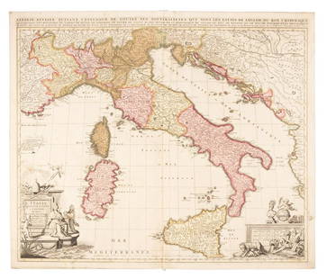
Sold2019Sanson map of Italy 1701Heading: Author: Sanson, Nicolas Title: L'Italie Divisee Suivant l'Estendue de Toutes ses Sourverainetes... Place Published: Amsterdam Publisher:Pieter Schenk Date Published: 1701 DescSee Sold Price
Sold20211652 Sanson Map of the Arabian Peninsula and the RedTitle: 1652 Sanson Map of the Arabian Peninsula and the Red Sea -- L'Arabie Petree, Deserte, et Heureuse Cartographer: N Sanson Year / Place: 1652, Paris Map Dimension (in.): 7.5 X 9.5 in. This is a rSee Sold Price
Sold2023Sanson map of ancient Asia 1650Heading: Author: Sanson, Nicolas Title: Asia Vetus Place Published: Paris Publisher: Date Published: [1650] Description: Copper-engraved map, hand-colored in outline; colored decorSee Sold Price
Sold20191700 c. Sanson Map of the Arabian Peninsula and the RedTitle/Content of Map: 1700 c. Sanson Map of the Arabian Peninsula and the Red Sea -- Arabia Petrea, Deserta et Felix Per N. Sanson Date: c. 1700 Cartographer: Based on N. Sanson Size: 7.5 X 9.5 in. ThSee Sold Price
Sold20231683 Sanson Map of South America -- Amerique MeridionaleTitle: 1683 Sanson Map of South America -- Amerique Meridionale Cartographer: N Sanson Year / Place: 1683, Paris Map Dimension (in.): 7.8 X 10/8 in. This is a superb map of South America with a charmiSee Sold Price
Sold2020Nicolas Sanson Map of Morea Greece 1692Nicolas Sanson (1600-1677), "La Moree et les Isles de Zante, Cafalonie, Ste Maure, Cerigo, &c." Paris: Hubert Jaillot, 1692. This hand-colored map depicts Morea, the southern part of Greece, with theSee Sold Price
Sold20191705 Sanson map of Russia w/huge marginsReserve Reduced! Beautiful specimen with modern hand coloring painstakingly applied. A strongly engraved map of European Russia showing its political divisions, major topographical features, cities anSee Sold Price
Sold20231700 Sanson Map of Sri Lanka and the Maldives -- Ceylan, et les MaldivesTitle/Content: 1700 Sanson Map of Sri Lanka and the Maldives -- Ceylan, et les Maldives Cartographer: N Sanson Year/Place: 1700, Paris Dimensions: 7.2 X 9.5 in. Description: This is an exquisite map oSee Sold Price
Sold2021Tallis, John (Pub) 1852 Map. Japan & Corea. KoreaSteel Engraved Map with Original Outline Hand Color Published 1852-56 by John Tallis, London for "The Universal Pronouncing Dictionary" by Thomas Wright. Drawn & Engraved by John Rapkin. Centre fold aSee Sold Price
Sold2021WWII UNITED PRESS WAR MAP w 7 INDIVIDUAL MAPS JAPANTitle: WWII UNITED PRESS WAR MAP w 7 INDIVIDUAL MAPS JAPAN HAWAII WORLD PACIFIC THEATER Additional Information: WWII UNITED PRESS WAR MAP w 7 INDIVIDUAL MAPS JAPAN HAWAII WORLD PACIFIC THEATER WWII UNSee Sold Price
Sold2022AN ANTIQUE PRINTED MAP 'JAPAN' BY A. ARROWSMITH, London 1802. Steel plate Uncoloured. AnAN ANTIQUE PRINTED MAP 'JAPAN' BY A. ARROWSMITH, London 1802. Steel plate Uncoloured. An interesting, clear and detailed map of Japan, excluding Hokkaido but including a blank outline of Korea. The naSee Sold Price
6 days LeftTrillium Antique Prints & Rare BooksSanson - Map of California as an Island, Mexico (Audience de Guadalajara)$90(4 bids)
6 days LeftTrillium Antique Prints & Rare BooksSanson - Map of North America with California as an Island$85(2 bids)
6 days LeftTrillium Antique Prints & Rare BooksSanson - Map of Moluccas, Celebes, & Gilolo (Halmahera)$75
BonhamsSPEED (JOHN) AND WILLEM BLAEU Pictorial title-pages to Speed's 'Theatre of the Empire of Great B...£10
Jun 15Riverfront AuctionsC. 1730 Map of North Rhine-Westphalia, Germany after N. Sanson by Covens and Mortier$5
5 days LeftLeon GalleryJodocus Hondius 1606 (Jodocus Hondius and Cornelis Claesz) - India Orientalis₱40,000
BonhamsSHOBERL (FREDERIC) The World in Miniature, FIRST EDITION, COMPLETE IN 43 VOLUMES, R. Ackerman, [...£3,000
607 Lots AwayJapan-Miyako-Collection-Art Auction-Co-LtdA group of silver coins from the late Qing Dynasty to the Republic of China$300(1 bid)
2024Japan-Miyako-Collection-Art Auction-Co-LtdQing Dynasty gold coin made by Yuan Datou in the 16th yearSee Sold Price
2024Japan-Miyako-Collection-Art Auction-Co-LtdQing Dynasty Daoguang first year gold figure coinSee Sold Price
608 Lots AwayJapan-Miyako-Collection-Art Auction-Co-LtdA group of silver coins from the late Qing Dynasty to the Republic of China$300


![[JAPAN]. A lot of 3 maps sold together: [JAPAN]. A lot of 3 maps sold together. Engravings on paper, generally fine. Including: Guillaume Sanson. DE EILANDEN VAN JAPAN. 8.5 x 24cm. [1705] ** Jacques Nicolas Bellin. CARTE DES ÃŽLES DU JAPO](https://p1.liveauctioneers.com/1124/187577/94368871_1_x.jpg?height=310&quality=70&version=1607095126)


![MAP, Japan, Yamashita: Omi Province, Japan. Shigemasa Yamashita, [Omi Province] ?mi no Kuni saikenzu, 1824 (circa). Black & White. This wall-sized woodblock map of the Omi Province was created by Shigemasa Yamashita. This h](https://p1.liveauctioneers.com/6576/279721/147265524_1_x.jpg?height=310&quality=70&version=1677104593)


![Sanson map of ancient Asia 1650: Heading: Author: Sanson, Nicolas Title: Asia Vetus Place Published: Paris Publisher: Date Published: [1650] Description: Copper-engraved map, hand-colored in outline; colored decor](https://p1.liveauctioneers.com/642/310901/166355383_1_x.jpg?height=310&quality=70&version=1701367957)


