Sold20241654 Sanson Kingdom Of Boheim MapBoehiem divided into it fifteen circles, or Provices, hand coloredSee Sold Price
Sold2018Sanson: Kingdom of Aragon (NE Spain & Balearic Isles)Reserve Reduced! Title of Map: Les Estats de la Couronne d'Arragon en Espagne Cartographer: Sanson/Mariette Place / Date: Paris / 1653 Size: 15" x 8 1/4" Condition: outline color; light overall age toSee Sold Price
Sold2024Map. Portugal. Nicolas SansonPortugal. Nicolas Sanson Hand Colored Map Paris. 1654 17" x 23".See Sold Price
Sold2022MAP, China & Korea, SansonChina & Korea. Nicolas Sanson, Royaume de la Chine, from Geographise en Historise Werelt Beschryving, 1683 (published). Hand Color. This finely engraved map of the Kingdom of China includes the islandSee Sold Price
Sold2022Holy Land.- Sanson (Guillaume) Iudaea, seu Terra Sancta quae Hebraeorum sive Israelitarum in suasNO RESERVE Holy Land.- Sanson (Guillaume) Iudaea, seu Terra Sancta quae Hebraeorum sive Israelitarum in suas Duodecim Tribus Divisa, map of the kingdoms of Judea and Israel with tribal divisions, engrSee Sold Price
Sold2019Two Maps by Nicolas Sanson (1600-1667, Paris),Two Maps by Nicolas Sanson (1600-1667, Paris), "L'Estats de'Englise et de Toscane," 1648, together with "Nicens Ory de Mercie," 1654 H. - 17 in., W. - 23 in. (2 Pcs.)See Sold Price
Sold2015Berry (William) - Africa Divided according to thelarge map of the continent after Sanson, showing the various nations, empires and kingdoms, title panel above and decorative title cartouche upper right, a detailed manuscript note referring to an accSee Sold Price
Sold2017Moll - Correct Map of the Whole World, 1719Herman Moll (1654?-1732), cartographer and publisher A New & Correct Map of the Whole World Shewing y.e Situation of its Principal Parts. Viz the Oceans, Kingdoms, Rivers, Capes, Ports, Mountains, WooSee Sold Price
Sold20181683 Sanson Map of the Great Lakes and the Upper EastTitle/Content of Map: 1683 Sanson Map of the Great Lakes and the Upper East Coast -- Le Canada, ou Nouvelle France, &c. Tiree de diverses Relations des Francois, Anglois, Hollandois, &c. Date: 1683, PSee Sold Price
Sold20211683 Sanson Map Great Lakes to Newfoundland -- LeTitle: 1683 Sanson Map Great Lakes to Newfoundland -- Le Canada, ou Nouvelle France, &c. Tiree de diverses Relations des Francois, Anglois, Hollandois, &c. Cartographer: N Sanson Year / Place: 1683 c.See Sold Price
Sold20181683 Sanson Map of the Great Lakes and the Upper EastTitle/Content of Map: 1683 Sanson Map of the Great Lakes and the Upper East Coast -- Le Canada, ou Nouvelle France, &c. Tiree de diverses Relations des Francois, Anglois, Hollandois, &c. Date Printed:See Sold Price
Sold20231652 Sanson Map of the World -- L'Hydrographie ou Descriprion de L'Eau c'est a dire des Mers,Title: 1652 Sanson Map of the World -- L'Hydrographie ou Descriprion de L'Eau c'est a dire des Mers, Golfes, Lacs, Destroits, et Rivieres principales, qui font dans la Surface du Globe Terrestre . . .See Sold Price
Sold2022Alexis Hubert Jaillot and Nicolas Sanson - Map of the Grand Duchy of Moscow, Etching, 1708.Alexis Hubert Jaillot (French, 1632-1712) and Nicolas Sanson (French, 1600-1667) - Map of the White Russia or the Grand Duchy of Moscow, Etching, 1708. Title: Les Estats du Czaar de Russie Blanche ouSee Sold Price
Sold2020Nicolas Sanson Map of AsiaNicolas Sanson (1600-1667) "L'Asie divisee en ses Principales Regions, et ou se peuvent voir l'estendue, Des Empires, Monarchies, Royaumes, et Estats," Paris: Jaillot, ca. 1719. Hand colored map of AsSee Sold Price
Sold2024Sanson - Map of Canada or New France with the Great LakesThis strong map engraving is from the Dutch edition of Nicolas d'Abbeville Sanson's Cartes Generales de Toutes les Parties du Monde. The work was published in Utrecht in 1683 for the author. The atlasSee Sold Price
Sold2024Nicolas Sanson - Map of Asia / Asia divided into its Principal RegionsCopper engraving, 1600s/1700s, "Asia divided into its Principal Regions." By Mr. Sanson, Geographer Ordinary to the King. Size: 58 cm x 88 cm.See Sold Price
Sold2018RARE 17TH C. SANSON MAP OF LUXEMBOURGAlexis-Hubert Jaillot (c. 1632-1712); Nicolas Sanson (1600-1667) "Le Duche de Luxembourg Divise en Quarter Walon et Allemand....", hand colored engraving, published 1700 from earlier plates, Paris, frSee Sold Price
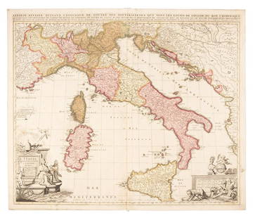
Sold2019Sanson map of Italy 1701Heading: Author: Sanson, Nicolas Title: L'Italie Divisee Suivant l'Estendue de Toutes ses Sourverainetes... Place Published: Amsterdam Publisher:Pieter Schenk Date Published: 1701 DescSee Sold Price
Sold20211652 Sanson Map of the Arabian Peninsula and the RedTitle: 1652 Sanson Map of the Arabian Peninsula and the Red Sea -- L'Arabie Petree, Deserte, et Heureuse Cartographer: N Sanson Year / Place: 1652, Paris Map Dimension (in.): 7.5 X 9.5 in. This is a rSee Sold Price
Sold2023Sanson map of ancient Asia 1650Heading: Author: Sanson, Nicolas Title: Asia Vetus Place Published: Paris Publisher: Date Published: [1650] Description: Copper-engraved map, hand-colored in outline; colored decorSee Sold Price
Sold20191700 c. Sanson Map of the Arabian Peninsula and the RedTitle/Content of Map: 1700 c. Sanson Map of the Arabian Peninsula and the Red Sea -- Arabia Petrea, Deserta et Felix Per N. Sanson Date: c. 1700 Cartographer: Based on N. Sanson Size: 7.5 X 9.5 in. ThSee Sold Price
Sold20231683 Sanson Map of South America -- Amerique MeridionaleTitle: 1683 Sanson Map of South America -- Amerique Meridionale Cartographer: N Sanson Year / Place: 1683, Paris Map Dimension (in.): 7.8 X 10/8 in. This is a superb map of South America with a charmiSee Sold Price
Sold2020Nicolas Sanson Map of Morea Greece 1692Nicolas Sanson (1600-1677), "La Moree et les Isles de Zante, Cafalonie, Ste Maure, Cerigo, &c." Paris: Hubert Jaillot, 1692. This hand-colored map depicts Morea, the southern part of Greece, with theSee Sold Price
Sold20191705 Sanson map of Russia w/huge marginsReserve Reduced! Beautiful specimen with modern hand coloring painstakingly applied. A strongly engraved map of European Russia showing its political divisions, major topographical features, cities anSee Sold Price
5 days LeftTrillium Antique Prints & Rare BooksSanson - Map of California as an Island, Mexico (Audience de Guadalajara)$160(4 bids)
5 days LeftTrillium Antique Prints & Rare BooksSanson - Map of North America with California as an Island$120(3 bids)
5 days LeftTrillium Antique Prints & Rare BooksSanson - Map of Moluccas, Celebes, & Gilolo (Halmahera)$75
2 days LeftJasper52Map of the World Showing the Geographical Distribution & Range of The Principal Members Of The$45
BonhamsSPEED (JOHN) AND WILLEM BLAEU Pictorial title-pages to Speed's 'Theatre of the Empire of Great B...£10
3 days LeftJasper52SOUTHERN AFRICA Monomotapa (Mutapa Kingdom) Cafrerie (Kaffraria) MALLET 1683 map$30
4 days LeftFreeman's | Hindman[MAP]. ORTELIUS, Abraham. Presbiteri Iohannis, sive, Abissinorum Imperii Descriptio. 1592.$200
BonhamsMITCHELL (SAMUEL AUGUSTUS) A New Universal Atlas Containing Maps of the Various Empires, Kingdom...£1,300


![Sanson map of ancient Asia 1650: Heading: Author: Sanson, Nicolas Title: Asia Vetus Place Published: Paris Publisher: Date Published: [1650] Description: Copper-engraved map, hand-colored in outline; colored decor](https://p1.liveauctioneers.com/642/310901/166355383_1_x.jpg?height=310&quality=70&version=1701367957)


![[MAP]. ORTELIUS, Abraham. Presbiteri Iohannis, sive, Abissinorum Imperii Descriptio. 1592. (1 of 2)](https://p1.liveauctioneers.com/197/329395/177650536_1_x.jpg?height=282&quality=70&version=1715364962)

![British Plantation Map of the Americas [179303] (1 of 1)](https://p1.liveauctioneers.com/2699/331495/178785748_1_x.jpg?height=282&quality=70&version=1717094933)


