Sold20211754 Rocque Map of Paris on Linen -- A Plan of ParisTitle: 1754 Rocque Map of Paris on Linen -- A Plan of Paris &c. This Survey has been Reduced to the Same Scale and that of London & the County Arount It Survey'd and Publish'd in 16 Sheets by John RocSee Sold Price
Sold2021Alexandre Vuillemin, Plan Pittoresque de ParisAlexandre Vuillemin, Plan Pittoresque de Paris (1840). large, linen-backed folding map.Estimate: $100 - $200See Sold Price
Sold2017Bellin: Antique Plan of Cusco, 1754Map: Plan de Cusco Cartographer: Bellin Place & Date: Paris / 1754/1760 Size: 5 3/4" x 9 1/8" Condition: b&w; light overall age toning; a stain in the wide right margin; mounted on contemporary paperSee Sold Price
Sold2017Bellin: Antique Plan of Lima, 1754Map: Plan Scenographique de la Cite des Rois ou Lima Capitale du Royaume de Perou Cartographer: Bellin Place & Date: Paris / 1754/1760 Size: 12 1/2" x 7 5/8" Condition: b&w; light overall age toning;See Sold Price
Sold20241812 large French map of Paris plan routier de la Ville et faubourgLarge engraving of Paris and its surrounding area dated 1812 , cooper engraving in the manner of the Turgot map ,Jean Pierre printer , a Paris, chez Jean, Rue St Jean de Beauvais, N° 10, It is thSee Sold Price
Sold2019Georges Peltier, old map of ParisGeorges Peltier, old map of Paris, "Plan de Paris a vol dóiseau", c. 1920-1940, colored lithograph on paper, 32.5"h x 41.5"w (sight), 33.5"h x 42.5"w (frame) Provenance: The Estate of Huguette ClarSee Sold Price
Sold2022Encyclo. Britannica C1880 Map. Paris City PlanLithograph Maps Published 1875-98, Edinburgh & London for "Encyclopaedia Britannica" Ninth Edition. Paper Size: 15.5 x 10.5 inch (39 x 27cm) Good ConditionSee Sold Price
Sold2020Georges Louis Rouge Plan of Paris Map 1765Georges-Louis Le Rouge (ca. 1712-1780), "Plan de Paris et de ses faubourgs en l'état qu'il étoit en 1765." This attractive map features the city of Paris along with points of interest. DimensionSee Sold Price
Sold2022Plan de Paris 1927 Made for Washington Sq. BookPlan de Paris map by Ilonka Karasz printed for sale at the Washington Square Bookshop in 1927. Measures 27.5 in. x 36 in. and folds to 14 in. x 9 in. Loose in a leatherette folio. Color with gilt on tSee Sold Price
Sold2023FRAMED PARIS METRO MAP ON LINEN BY LAMONTPrinted linen Paris Metro Rail Map by Lamont. Framed in a modernist wood frame, under glass. Measures; 20 X 29"See Sold Price
Sold2023Vintage Framed Map of Paris1957 Blondel La Rougery Paris Map. Marked Plan De Paris A Vol D'Oiseau, Blondel La Rougery, Edit. Imp. 7, Rue Saint Lazare Paris 9e, Dressee Et Imprimee Par Blondel La Rougery, tous droits d reproductSee Sold Price
Sold2017Map of Paris Monuments Metropolitan Autobus, 1971Paris Map "Plan Commode de Paris/ Rues et Monuments Metropolitan Autobus". 1971. 4 x6 red boards. Paris Metro map tipped in at the front. Multi-fold map laid in, printed on both sides approx. 22 x 30,See Sold Price
Sold2020Hermes "Universite de Paris" Silk ScarfHermes silk scarf, titled above "Ici est le vrai portrait naturel de la ville, Cité, Université de Paris, 1576," depicting map of Paris based on Rossingol's plan of Paris, signed "Hermes Paris." 35"See Sold Price
Sold2024Poster "Les jardins de Paris", illustrated map and plan of Paris with its parcs, gardens, monuments,The "Gardens of Paris" poster has the same proportions as a modern map but is illustrated, as were the antique maps, in the same way that the "portulans" of the sixteen century were.With precisely depSee Sold Price
Sold20231853 FRENCH ANTIQUE MAP OF PARIS Fatout Vuillemin on linen backing1853 LARGE FRENCH ANTIQUE MAP OF PARIS Vuillemin on linen backing large French map of Paris circa 1853 edited by “Fatout éditeur Boulevard Poissoniere 17 ”, Alexandre Vuillemin (1812-See Sold Price
Sold20231860 LARGE FRENCH ANTIQUE MAP OF PARIS Fatout Vuillemin on linen backing1860 LARGE FRENCH ANTIQUE MAP OF PARIS Vuillemin on linen backing large French map of Paris circa 1860 edited by “Fatout éditeur Boulevard Poissoniere 17 ”, Alexandre Vuillemin (1812-See Sold Price
Sold2022AN ANTIQUE PRINTED MAP BY J. N. BELLIN, Paris 1752. PLAN DE LA VILLE DE MEACO. CopperplateAN ANTIQUE PRINTED MAP BY J. N. BELLIN, Paris 1752. PLAN DE LA VILLE DE MEACO. Copperplate Uncoloured. A well engraved and detailed plan of the port and city of Meaco, present-day Kyoto. Jacques NicolSee Sold Price
Sold2018Paris.- Loosjes (Adriaan, publisher) Plattegrond vanParis.- Loosjes (Adriaan, publisher) Plattegrond van Parijs, Naar de Jongste Verdeeling in 48 Wyken, Dutch plan of Paris, with small inset map of the environs on Paris in the lower right, and title viSee Sold Price
Sold2023[PARIS]. Plan garanti complet ou le guide dans Paris.Paris: Lallemand, 1855. Large folding map of Paris with small views of the major monuments overprinted near their location on the map. 16mo, (630 x 885mm). Large printed map with watercoloured foldingSee Sold Price
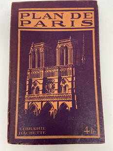
Sold2021PLAN DE PARIS Rues De Paris w/ MapLibrarie Hachette. "Liste Alphabetique Des Rues De Paris". Includes fold-out map by Imp Dufrenoy, Paris - "Grave chez Herisson Garin, 6, Rue Vercingetorix par E. Schwartz" in bottom left corner. Map mSee Sold Price
Sold2020(PICTORIAL MAP – PARIS.) Ministry of Tourism.(PICTORIAL MAP – PARIS.) Ministry of Tourism. View of the Center of Paris Taken from the Air. Large color-lithographed detailed aerial plan of Paris. 28x44 inches sheet size, wide margins; mountSee Sold Price
Sold2022MELCHOIR TAVERNIER "PLAN OF PARIS" ENGRAVINGMELCHOIR TAVERNIER "PLAN OF PARIS" ENGRAVING of a 1630 Map, watermark LANADimensions: 14 1/4 x 18 1/2See Sold Price
Sold2021J. Jerome, Rue Monge 38 Paris Map - 1880 - Backed onPAU ET SES ENVIRONS DEIDE AU 18 DE LIGNE ET A LA VILLE DE PAU 1880 J. Jerome, Rue Monge 38 Paris. Map backed on Linen. Has normal discoloration for age but is in excellent condition. Measures approx.See Sold Price
Featured4 days LeftJasper52A Plan of London on the same scale as that of Paris.. by John Rocque 1769 map$1,600
3 days LeftJasper521804 TRAVELS of Ledyard & Lucas in Africa antique w/ MAPS Voyages de MM. Lédyard$240
5 days LeftSwann Auction Galleries(PHILADELPHIA -- ROXBOROUGH/MANAYUNK.) John Levering. Plan of the Township of Roxborough$500
5 days LeftSwann Auction Galleries(NEW YORK CITY.) Bernard Ratzer. [The Ratzen Plan] To His Excellency Sr. Henry Moore. Bart.,$19,000
5 days LeftForum AuctionsLondon.- Cruchley (George Frederick) Cruchley's New Plan of London Shewing all the New and Intended£150
5 days LeftForum AuctionsLondon.- Wyld (James) Wyld's New Plan of London and it’s vicinity, lithographic map, 1886£100
5 days LeftForum AuctionsLondon.- Mogg (Edward) An Entire New Plan of the Cities of London & Westminster with the Borough of£100
4 days LeftJasper52Stanford's Map of Central London. Folding, linen-backed antique city plan 1905$550
5 days LeftSwann Auction Galleries(PARIS.) Sebastian Münster. Die Statt Parys Etlicher Mass Figuriert und Contrafetet nach$450(1 bid)
5 days LeftSwann Auction Galleries(WORLD.) Nicolas de Fer. Mappe-Monde ou Carte Generale de la Terre.$1,500
3 days LeftActivity AuctionsAir France Paris by Lancaster 1956 Eiffel Tower, Montmartre, Notre Dame$600


![[PARIS]. Plan garanti complet ou le guide dans Paris.: Paris: Lallemand, 1855. Large folding map of Paris with small views of the major monuments overprinted near their location on the map. 16mo, (630 x 885mm). Large printed map with watercoloured folding](https://p1.liveauctioneers.com/4096/288680/152743885_1_x.jpg?height=310&quality=70&version=1683550714)


![[Paris] - Stanford, Edward (1 of 1)](https://p1.liveauctioneers.com/94/330664/178342455_1_x.jpg?height=282&quality=70&version=1716466933)


![(NEW YORK CITY.) Bernard Ratzer. [The Ratzen Plan] To His Excellency Sr. Henry Moore. Bart., (1 of 1)](https://p1.liveauctioneers.com/199/332329/179231669_1_x.jpg?height=282&quality=70&version=1717450360)


