Sold20201842 Map of ChinaAuthor: Scott Title: 1842 Map of China Medium: Ink on Paper Dimensions: 9"X11.5" Description: Map of China dated 1842. Copper plate map. Engraved by R. Scott. Published by Thomas Nelson in Edinburgh.See Sold Price
Sold2023MAP, China, Korea & Japan, MercatorHondius' Map of China, Korea, and Japan. China, Korea & Japan. Mercator/Hondius, China, from Gerardi Mercatoris - Atlas sive Cosmographicae, 1623 (published). Hand Color. Besides China, this map depicSee Sold Price
Sold2021(PICTORIAL MAPS -- CHINA.) Group of 3 large offset(PICTORIAL MAPS -- CHINA.) Group of 3 large offset color-printed posters of Chinese natural and cultural heritage sites. China, mid-twentieth century *Taishan Mingsheng Tu. Scenic trail map of Mount TSee Sold Price
Sold2023MAP, China, BlaeuCentral China, Henan. Johannes Blaeu, Honan, Imperii Sinarum Provincia Quinta, from Novus Atlas Sinensis, 1655 (published). Hand Color. This map of the Henan province is centered on the Yellow River,See Sold Price
Sold2022MAP, China & Korea, SansonChina & Korea. Nicolas Sanson, Royaume de la Chine, from Geographise en Historise Werelt Beschryving, 1683 (published). Hand Color. This finely engraved map of the Kingdom of China includes the islandSee Sold Price
Sold20181781 Jesuit Voyage Missions MAP China Peking Philippine1781 Jesuit Voyage Missions MAP China Peking Philippines ASIA Lettres Edifiantes The ‘Lettres Edifiantes et Curieuses’ is a collection of reports and letters from Jesuit missions from around the wSee Sold Price
Sold2023MAP, China & Korea, BellinChina & Korea. Jacques Nicolas Bellin, L'Empire de la Chine pour Servir a l'Histoire Generale des Voyages, from Histoire Generale des Voyages, 1748 (dated). Hand Color. Attractive and detailed map ofSee Sold Price
Sold2022MAP, China, Korea & Japan, MollChina, Korea & Japan. Herman Moll, China According to the Newest and Most Exact Observations, 1720 (circa). Hand Color. Nice copper engraved map in Moll's typical style presents the Korean peninsula,See Sold Price
Sold2024West India Islands. Caribbean. La Salle settlement in Texas. LIZARS 1842 mapTITLE/CONTENT OF MAP: 'West India Islands and adjacent coasts of the United States, Mexico, Guatimala & Colombia' The map notes anecdotally the location of René Robert Cavelier, Sieur de La SalleSee Sold Price
Sold2023South America /Atlantic Ocean. Gran Colombia. United Provinces. LIZARS 1842 mapTitle: South America /Atlantic Ocean. Gran Colombia. United Provinces. LIZARS 1842 map Description: South America' by William Home Lizars (1842). Antique 19th century atlas map with original hand coloSee Sold Price
Sold2023MAP, China, AaChina & Korea. Pieter van der Aa, La Chine, Suivant les Nouvelles Observations de Messrs. de l'Academie Royale des Sciences, Etc. Augmentees de Nouveau, 1729 (circa). Black & White. A very uncommon maSee Sold Price
Sold2023MAP, China, BellinChina, Korea & Japan. Jacques Nicolas Bellin, Carte des Isles du Japon et la Presqu' Isle de Coree avec les Costes de la Chine Depuis Pekin Jusqua Canton, from Prevost's Histoire Generale des Voyages�See Sold Price
Sold20201842 map of New York City, Sidney MorseFrom the very first cerographic atlas ever published. Two tiny very lightly discolored areas at top edge; corner crease. 12 x 15. Reserve: $90.00 Shipping: Domestic: Flat-rate of $6.00 to anywhere witSee Sold Price
Sold2021Tallis, John (Pub) 1852 Map. China and Birmah. BurmaSteel Engraved Map with Original Outline Hand Color Published 1852-56 by John Tallis, London for "The Universal Pronouncing Dictionary" by Thomas Wright. Drawn & Engraved by John Rapkin. Centre fold aSee Sold Price
20231859 INDIA 1ed History Indian Revolt Sepoy Mutiny Voyages MAP China Illustrated1859 INDIA 1ed History Indian Revolt Sepoy Mutiny Voyages MAP China Illustrated George Dodds “History of the Indian Revolt” is a rare account of the Indian Rebellion of 1857, or more commoSee Sold Price
Sold2023Four Antique Maps, China & Asia, Gerard Mercator, Jacques BellinDescription: To include a 1628 map of China and Asia by from the Gerard Mercator Atlas Minor (framed), a 1748 copper engraved Jacques Bellin map of Cathay (Northern China & Southern Mongolia), a 1749See Sold Price
Sold20231859 INDIA 1ed History Indian Revolt Sepoy Mutiny Voyages MAP China Illustrated1859 INDIA 1ed History Indian Revolt Sepoy Mutiny Voyages MAP China Illustrated George Dodds “History of the Indian Revolt” is a rare account of the Indian Rebellion of 1857, or more commoSee Sold Price
Sold2022ANTIQUE PRINTED MAP 'CHINA' BY J. & C. WALKER, London 1843 - 1844. Attractive hand-colour. ThisANTIQUE PRINTED MAP 'CHINA' BY J. & C. WALKER, London 1843 - 1844. Attractive hand-colour. This interesting and detailed map of China was published in the atlas volume published as 'Maps of The SoSee Sold Price
Sold20201842 Map of North AmericaAuthor: Scott Title: 1842 Map of North America Medium: Ink on Paper Dimensions: 9"X11.5" Map of North America dated 1842. Engraved by R. Scott. Part of the New General Atlas of the World. Published bySee Sold Price
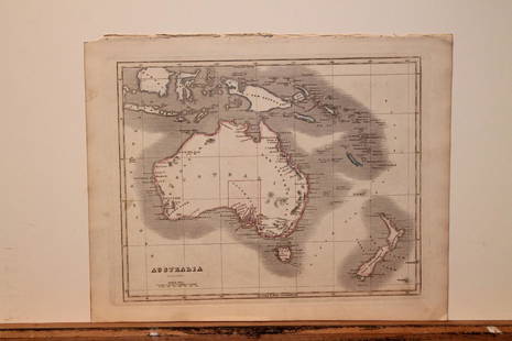
20201842 Map of AustraliaAuthor: Scott Title: 1842 Map of Australia Medium: Ink on Paper Dimensions: 11.5X9" Description: Map of Australia dated 1842. Copper plate map. Engraved by R. Scott. Published by Thomas Nelson in EdinSee Sold Price
Sold20201749 Engraved Map China Vusihyen Hu Chew FuEngraved map of the Chinese cities of Vusihyen and Hou Techeou Fou by Jacques Bellim circa 1749, Paris. Fine condition, measures 7.25 x 10". Reserve: $40.00 Shipping: Domestic: Flat-rate of $5.00 to aSee Sold Price
Sold2019Barclay, James 1809 Antique Map. ChinaOutline Hand Coloured Copper Engraved Map Published 1809, Leeds for "Barclay's Complete and Universal Dictionary of the English Language..." by the Rev. James Barclay. Paper Size: 10 x 8 inch (26 x 20See Sold Price
Sold20201842 Map of AsiaAuthor: Scott Title: 1842 Map of Asia Medium: Ink on Paper Dimensions: 11.5"X 9" Description: Map of Asia dated 1842. Copper plate map. Engraved by R. Scott. Published by Thomas Nelson in Edinburgh. PSee Sold Price
Sold20201842 Map of AustraliaAuthor: Scott Title: 1842 Map of Australia Medium: Ink on Paper Dimensions: 11.5"X9" Map of Australia dated 1842. Copper plate map. Engraved by R. Scott. Published by Thomas Nelson in Edinburgh. PartSee Sold Price
BonhamsCHINA - FIRST OPIUM WAR Military Sketch of the Operations against the City of Chin-Keang on the ...£300
1 day LeftRapid Estate Liquidators and Auction Gallery6 1980s 1990s National Geographic Magazines A$35
6 days LeftTrillium Antique Prints & Rare BooksSanson - Map of California as an Island, Mexico (Audience de Guadalajara)$90(4 bids)
6 days LeftTrillium Antique Prints & Rare BooksSanson - Map of North America with California as an Island$85(2 bids)
6 days LeftTrillium Antique Prints & Rare BooksSanson - Map of Moluccas, Celebes, & Gilolo (Halmahera)$75