Sold2024ANTIQUE MAP - REPRESENTATION OF THE TURKISH EMPIRE IN THE 16TH C.16TH C. FRAMED HAND COLORED ANTIQUE MAP - ABRAHAM ORTELIUS (BELGIAN, 1527-1598) REPRESENTATION OF THE TURKISH EMPIRE IN THE 16TH C. - TITLED "TURCICI IMPERII DESCRIPTO" - FRAME MEASURES APPROX. 23 1/2See Sold Price
Sold2017SDUK: Antique Map of the Turkish Empire in Europe, 1852Map: The Turkish Empire in Europe and Asia With The Kingdom of Greece Publication Date: 1852 Authors: CHARLES KNIGHT/GEORGE COX/S.D.U.K., WALKER, J. & C. Publisher: CHARLES KNIGHT/GEORGE COX/S.D.U.K.See Sold Price
Sold202117th c. Antique H/C Map of Ottoman / Turkish EmpireMap - Accuratissima et maxima totius Turcici Imperii tabula cum omnibus suis regionibus novissima delineatio | Title: Accuratissima et maxima totius Turcici Imperii tabula cum omnibus suis regionibusSee Sold Price
Sold202217th C Abraham Ortelius Map of Turkish Empire17th C Abraham Ortelius (Flemish, 1527-1598) Map of Turkish Empire from Theatrum Orbis Terrarum (Published London, 1606). Titled Representation of the Turkish Empire by Abraham Ortelius. Some loss toSee Sold Price
Sold20241569 MUNSTER COSMOGRAPHY LEAF w/ MAP antique 16th century1 leaf w/ woodcuts, from S. MUNSTER, Cosmographey (...) (Basel, 1569). With map. Double sided. With padding. Size 7 1/2 by 11 3/4 Pad 9 3/4 by 13 3/4" Text in German Very good condition Reserve: $140.See Sold Price
Sold2021Eleven Antique Maps of EuropeEleven Antique Maps of Europe , 16th-18th c., incl. Ptolemy from 1541 (4); a Blaeu map of "Regno di Napoli", Hondius map of the Holy Land, de Wit map of Southern Spain, an undated manuscript map of MeSee Sold Price
Sold2022Antique 16th Century Map South AmericaTitle: Antique 16th Century Map South America Description:Antique 16th Century Map South America Circa Date: 1598 Condition of piece: Map displays toning, some water stains, wrinkles and creases,See Sold Price
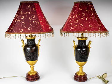
Sold2024ANTIQUE TURCICUM IPERIUM (TURKISH EMPIRE) MAPCartouche showing the Turkish Sultan on his throne and allegorical figures at either side brandishing weapons, with smaller cartouche at right h. 16-1/2 w. 21 in. (sight) overall: 23-1/4 x 27-1/4 in.See Sold Price
Sold2017Munster: Antique Map of the Iberian Peninsula, 1550Title: Tabula Europae II, Lovely mid-16th century woodblock map of the Iberian Peninsula Map maker: Sebastian Münster, Cosmographiae Universalis... Place and Year: Basel, c. 1550 Dimensions: 35.3 x 2See Sold Price
Sold2022Antique Turkish Ceramic PlatterAccording to a hand-painted attestation in the back, platter was made in the 16th Century; can neither confirm nor deny this claim. Has been used as wall decor for several years, as arrested by the atSee Sold Price
Sold2018Four Small Antique Maps Pertaining to Cyprusas follows: Hogenberg, F. and Braun G. Famaugusta, copperplate engraving (Cologne, late 16th century) sheet, 8.75 x 14 in., giving a birds-eye view of the Cypriot port city; Mercator, Hondius, JanssonSee Sold Price
Sold2018Thomson: Antique Map of Asiatic Turkey, 1814The magnificent Middle East map from Thomson's New General Atlas encompasses in great detail the Turkish empire's Asian territories from the Aegean to its borders with Persia and Russia. Cartographer:See Sold Price
Sold2024Antique TC Lotter Magni Turcarum Dominatoris Map19.5 X 22.5 Antique map by famous German cartographer Tobias Conrad Lotter of the Turkish empire, Magni Turcus Dominatoris Imperium. Shows regions of Europe, Asia, and Africa. Original publication donSee Sold Price
Sold20201633 1ed TURKISH Ottoman Empire Busbecq Letters1633 1ed TURKISH Ottoman Empire Busbecq Letters Constantinople Politics Elzevier Ogier Ghislain de Busbecq was a 16th-century Flemish author who is best known for his ambassador service to the OttomanSee Sold Price
Sold2017Bellin: Antique Map of Empire of Mexico, 1740Title/Content of Map: Empire of Mexico by Bellin Date Printed: c 1740-70's Cartographer: J.N. Bellin & J.F. La Harpe Material/Medium: Paper Size: 13" x 10" Copperplate engraved. Published in Paris. FrSee Sold Price
Sold202316th CENTURY MAP of ARMENIA BLACK & CASPAN SEA REGION by PTOLEMY ANTIQUEWOOD ENGRAVED HAND COLORED MAP of ARMENIA , BLACK & CASPAN SEA REGION from DELLA GEOGRAFIA DI TOLOMEO c. second half of 16th century Overall size 9 by 12 1/4" Very good condition Reserve: $104.00 ShipSee Sold Price
Sold2024Balkan Peninsula. Turkish Empire. East Rumelia Greece Servia. THE TIMES 1895 mapTITLE/CONTENT OF MAP: 'The Balkan Peninsula' DATE PRINTED: 1895 IMAGE SIZE: Approx 54.0 x 42.0cm, 21.25 x 16.5 inches (Large); Please note that this is a folding map. TYPE: Antique colour atlas map COSee Sold Price
Sold20241816 MAP SOUTHERN PART OF RUSSIA or MUSCOVY in EUROPE copper engraving ANTIQUEAntique engraved map of Southern part of Russia from A General Atlas, Being A Collection Of Maps Of The World And Quarters, Their Principal Empires, Kingdoms, &c. Containing Fifty Eight Maps And ChartSee Sold Price
Sold2024Auction An Antique Ottoman Silver and Turquoise Statement Ring, c. 16th-18th Century AuctionThis exquisite statement ring, made from verde marron and cyan turquoise set in silver, dates back to the Ottoman Empire period (c. 16th-18th Century). It exemplifies the intricate craftsmanship and lSee Sold Price
Sold2022Antique Silk Italian Brocade Fragment Panel, Venetian 16th century With Ottoman MotifsAntique and Rare Silk Italian Brocade Fragment Panel. Venitian 16th Century with Ottoman / Turkish Motifs. Size: 130 cms x 45 cms. ( 51 ins x 17 ins ).See Sold Price
Sold2021Spanish Antique Mexico & Los Angeles Regional MapsThree antique repro 16th Century and 18th Century maps produced circa 1940s. Includes (1) 19" x 24" 1754 map of Los Angeles by Enrique Cervantes. Features etched illustration of various sections of thSee Sold Price
Sold2023ANTIQUE 18TH C HAND COLORED MAP OF OTTOMAN EMPIREAn antique early 18th-century hand-colored engraved map representing the Ottoman Empire. Published in Nuremberg, Germany, 1720. Titled Imperium Turcicum, technical information in Latin in the lower leSee Sold Price
Sold2024C 1893 Victorian Map - Turkey - Armenia Cyprus Irak - Arabi - Turkish Empire 1850C 1893 Victorian Map - Turkey - Armenia Cyprus Irak - Arabi - Turkish Empire 1850 Measure 14"in H x 18"in WSee Sold Price
Sold2018SDUK: Antique Map of Europe, 1845TITLE/CONTENT OF MAP: 'EUROPE; inset table of population by country' The map shows Lombardia-Venetia as part of the Austrian Empire, the independent Ionian Islands, and Turkish Crete DATE PRINTED: 184See Sold Price
5 days LeftForum AuctionsLevant.- Sandys (George) [A Relation of a Journey: containing a Description of the Turkish Empire of£50
3 days LeftJasper521582 JUSTIN Iustini ex Trogi Pompeii historiis Philippicis antique vellum 16th c$300
6 days LeftPrime Auction Gallery, Inc.Antique Framed 16th C. Commemorative Plaque & Document C.$1,200
3 days LeftJasper521771 GERMAN LAW BOOK antique FOLIO bound in VELLUM 16th C. ANTIPHONAL MANUSCRIPT$360
3 days LeftJasper521571 ROMAN HISTORY ILLUSTRATED antique FASTOS MAGISTRATUM ET TRIUMPHORUM 16th C.$1,100
4 days LeftThousand Planet Auction HouseAntique Islamic Jasper Ring, Possibly Ottoman Empire, c. 18th-19th Century CE$25
3 days LeftJasper521582 ROMAN GLADIATORS HISTORY antique VELLUM BINDING 1st edition PLANTIN 16th C.$500
Jun 20Flanders AuctionsAn antique 'Coptic Crucifix', Noord-Africa, 15th/16th C. (W:5,1 x H:14,2 cm)€240
3 days LeftLunds Auctioneers & Appraisers Ltd.Antique Map: "Nortfolcia Norfolk", J. Blaeu, C.1662, 15 3/8" x 20".CA$50
3 days LeftJasper52EARLY 19th c. KORAN OTTOMAN TURKISH MANUSCRIPT ILLUMINATED antique QURAN ISLAMIC$1,900
3 days LeftLunds Auctioneers & Appraisers Ltd.Antique Map: "Orcadum et Schetlandi" G. Blauew, C.1654, 20 1/2" x 24".CA$50
3 days LeftLunds Auctioneers & Appraisers Ltd.Antique Map: "Regiones Sub Polo Arctico", Johannes Blaeu C.1650, 16 3/8" x 21 1/4".CA$100
3 days LeftLunds Auctioneers & Appraisers Ltd.Antique Map: "Cornubia Davonia Somersetus..." After Mereatorem, Hondius, C.1633, 16 3/8" xCA$50
Jun 19Flanders AuctionsAn antique map of Ingelumunster and two 'Heerlijkheden van Picquenij', 18th C. (W:42 x H:33 cm)€160
4 days LeftJasper52Cary's reduction of his large map of England & Wales'. Turnpikes canals &c 1821$360


![[Maps & Atlases] Speed, John: The Turkish Empire (1 of 2)](https://p1.liveauctioneers.com/65/332523/179335176_1_x.jpg?height=282&quality=70&version=1717709446)