Sold2021VINTAGE GOLD FOIL 1630 ANTIQUE WORLD MAPVINTAGE GOLD FOIL 1630 ANTIQUE WORLD MAP "Nova Totius Terrarum Orbis Geographica Ac Hydrographica TAbvla" Print, Framed. Size: 23 X 19 inches. Private Collection.See Sold Price
Sold2024World Map Print "Nova Totius Terrarum Orbis" by Willem Blaeu - Dutch circa 1606World Map Print "Nova Totius Terrarum Orbis" by Willem Blaeu - Dutch circa 1606. Matted and framed Old World brought forward in the piece both colorful and detailed. Measures H 29" x W 35" and weightSee Sold Price
Sold2024Nova Totius Terrarum Orbis Reproduction Map19" x 25". Framed modern reproduction of an antique world map depicting two sides of the globe flatly with colored illustrations around the edges. Minor wear, some marks and scratches to frame consistSee Sold Price
Sold2022Historic Map Print, Nova Totius Terrarum Orbis Tabula, Framed31.5in w x 1in d x 28.5in hSee Sold Price
Sold2024Nova Totius Full Color Geographical World MapVintage full color world map in Latin, reading Nova Totius Terrarum Orbis Geographica Ac Hy Drographica Tabula. Depicts the world map with Latin sections and margins are filled with Greco Roman figureSee Sold Price
Sold2017Framed Colored Engraved 17th C. World Map"Nova Totius Terrarum Sive Novi Orbis Tabula" Framed Colored Engraved 17th C. World Map by Willem Janszoon Blaeu - This interesting piece is an early world map created by Willem Janszoon Blaeu. The maSee Sold Price
Sold2018Hand Colored Map of the World, Willem BlaeuWillem Blaeu, (Dutch, 1571-1638) "Nova Totius Terrarum Orbis Geograhica ac Hydrographica" originally published 1606 Nice old color example of Blaeu's classic world map Approx. 19.5" x 25.5" (unframed)See Sold Price
2022Blaeu, Johannes (Netherlands, 1596-1673) "The New World Map" Double Hemisphere World Map C. 1664Nova et Accuratissima Totius Terrarum Orbis Tabula Translated "The New World Map", Hand Colored w/ Elaborately Decorated Spandrels.   Sight View 16" x 21-1/2", Overall View 21" x 25-1/2"See Sold Price
Sold2019ORBIS TERRARUM TYPUS DE INTEGROIN PLURIMIS WORLD MAPHuge 40" x 30" Framed Gold Foil Map 1660 Nicolaus Visscher Orbis Terrarum Print. Actual map is 21" x 31"See Sold Price
Sold2023Two Maps, Africa by Eustache Herisson, 1809, World Hemispheres 1832 Reprint after A.H Brue, GermanDescription: An antique Africa map, in French and dated 1809 by Eustache Herisson, and a reprit of an early 19th century map of World Hemispheres by Adrien-Hubert Brue. Type: MapMaterials: PaperMarkinSee Sold Price
Sold2017World mapWorld map 'Nova Totius Terraum Orbis Geographica Ac Hydrographica Tabula', copper engraving map of Heinrich Hondius, dated 1630,two hemispheres the world map, surrounded by rich allegorical representaSee Sold Price
Sold2023NOVA TOTIUS TERRARUM ORBIS FRENCH BRASS PLAQUEFull map title: Nova Totius Terrarum Orbis Geographica ac Hydrographica Tabula. Possibly modeled after Henry Hondius' 1636 map but having altered marginalia and with names adjusted to French instead oSee Sold Price
Sold2023Antique Print - World - Map of the World in Hemispheres - Philipp Cluver - 1701Title: Antique Print - World - Map of the World in Hemispheres - Philipp Cluver - 1701 Date: 1701 Material: Paper Dimensions: 27 cm x 13 cm Description: A detailed small map from ”IntroductionisSee Sold Price
Sold2018European School 20th century copy of a 1613 map paintedEUROPEAN SCHOOL (20th century) "Nova Totius Terrarum (Map)" Painted leather. Including Frame: 49 1/2 x 63 3/4 inches. Signed lower right in the inner picture: Mari Shermann.See Sold Price
Sold20243 Vintage The World Lithographs, By Jansson3 lithographs of the world, by Jansson, 1632. Marked on lower right corners D.A.C. Inc, NY, No. 1693, made in USA. Depicts the world with the words Nova Totius Terrarum Orbis Geographica ac HydrographSee Sold Price
Sold20233 Vintage The World Lithographs, By Jansson3 lithographs of the world, by Jansson, 1632. Marked on lower right corners D.A.C. Inc, NY, No. 1693, made in USA. Depicts the world with the words Nova Totius Terrarum Orbis Geographica ac HydrographSee Sold Price
Sold20233 Vintage The World Lithographs, By Jansson3 lithographs of the world, by Jansson, 1632. Marked on lower right corners D.A.C. Inc, NY, No. 1693, made in USA. Depicts the world with the words Nova Totius Terrarum Orbis Geographica ac HydrographSee Sold Price
Sold2023"Nova totius Terrarum..." Hand Colored Reproduction Map"Nova totius Terrarum..." Reproduction MapSee Sold Price
Sold2017Map Chart of South & North America, R di RattiMap Chart of North and South America. 'Nova Totius Terrarum Geographica AC Hydrographica". Vintage silk work by R di Ratti, signed. Likely based on a map chart by Willem Blaeu circa 1640.See Sold Price
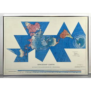
Sold2023Richard Buckminster Fuller Dymaxion World Map Print, 1980 FullerRichard Buckminster Fuller Dymaxion World Map Print, 1980 Fuller Dimensions: H: 22.5 inches: W: 34.5 inches --- -- We offer curbside delivery to NYC, Manhattan, Close Brooklyn, Hoboken about a week afSee Sold Price
Sold2017Framed Geographica Map Engraving (28E-EK)Framed Authentic Nova Totius Terrarum Orbis Geographica AC Hydrographica Tabula Map. Mixed Engraving printed in the late 1800's to early 1900's. All have the Mixed stamp from the Museum. These are theSee Sold Price
Sold2023Antique Map Print - Map of World - Scheme of Oceanic and Continental BasinsDescription: This vibrant hand-colored map of the world was published in Chicago by Rand McNally in the last quarter of the 19th century for inclusion in the company’s geography textbook, McNallSee Sold Price
Sold2021After Henricus Hondius II (Dutch, 1597-1651)After Henricus Hondius II (Dutch, 1597-1651) , "Nova Totius Terrarum Orbis Geographica AC Hydrographica Tabula", later printing, hand-colored double-hemisphere map, exuberantly decorated with represenSee Sold Price
Sold2016Beautifully Colored Jan Van Loon World MapOrbis Terrarum Nova... Jan Van Loon (c. 1611-1686). Engraved map with original hand color in full. London: Moses Pitt, 1680. 17 3/4 x 21 inches visible, 28 1/4 x 31 3/4 inches framed. A fine example oSee Sold Price
5 days LeftTrillium Antique Prints & Rare BooksBraun & Hogenberg, pub. 1575 - View of Moscow, Russia$150(2 bids)
5 days LeftTrillium Antique Prints & Rare BooksBraun & Hogenberg, pub. 1575 - View of Castle of Segeberg (Burg Segeberg) in Holstein, Germany$100
5 days LeftTrillium Antique Prints & Rare BooksBraun & Hogenberg, pub. 1575 - View of Wroclaw (Breslau), Poland$100(1 bid)
5 days LeftTrillium Antique Prints & Rare BooksBraun & Hogenberg, pub. 1575 - Views of Italy: Urbino and Sulmona$100(1 bid)
5 days LeftTrillium Antique Prints & Rare BooksBraun & Hogenberg, pub. 1575 - View of Bristol, England$100
5 days LeftTrillium Antique Prints & Rare BooksSanson - Map of California as an Island, Mexico (Audience de Guadalajara)$160(4 bids)
5 days LeftTrillium Antique Prints & Rare BooksSanson - Map of North America with California as an Island$120(3 bids)
5 days LeftTrillium Antique Prints & Rare BooksCluver & De L'Isle - Map of the Eastern Hemisphere (Europe, Asia, Africa and part of Australia)$75
5 days LeftTrillium Antique Prints & Rare BooksSanson - Map of Moluccas, Celebes, & Gilolo (Halmahera)$75
2 days LeftJasper52World War 2 Europe Battle of the Atlantic 1939-43 Axis Expansion limits 1959 map$15