Sold2020Italian edition of Sanson's map of North America, 1677Heading: Author: Rossi, Giacomo Giovanni/ Nicolas Sanson Title: L'America Settentrionale. Nuovamente Corretta et Accresciuta Secondo le Relationi Piu Moderne da Guglielmo Sansone Geografo di S.M. ChrSee Sold Price
Sold2023Giambattista Albrizzi. Two Maps of North America(Italian, 1698-1777). Map of North America and map of Canada and the Great Lakes, 1740, engravings, sight size of each: 13 1/2 x 17 in., both framed.See Sold Price
Sold2023Important transitional 1836/46 Burroughs map of N. AmericaImportant and rare true first edition example of map of North America by S. Augustus Mitchell and H. N. Burroughs. Texas is shown in its largest appearance, extending north to the Arkansas River and wSee Sold Price
Sold2018AFTER NICOLAS SANSON (FRENCH, 1600-1667) MAP OF NORTHAFTER NICOLAS SANSON (FRENCH, 1600-1667) MAP OF NORTH AMERICA, hand-colored, on laid paper, title in cartouche to upper left corner lettered "NORTH AMERICA / Divided into it's Principall Parts / whereSee Sold Price
Sold2018ANTONIO ZATTA (ITALIAN, 18TH CENTURY) MAP / ATLAS OFANTONIO ZATTA (ITALIAN, 18TH CENTURY) MAP / ATLAS OF NORTH AMERICA, SET OF 12, hand-colored, on laid paper, comprising title page lettered in part "LE / COLONIE UNITE / DELL' / AMERICA SETTENTR'LE." aSee Sold Price
Sold201812V Francis Parkman THE WORKS OF FRANCIS PARKMAN 192212V Francis Parkman THE WORKS OF FRANCIS PARKMAN 1922 Centenary Edition Folding Maps Illustrated Frontispieces Oregon Trail Jesuits North America Montcalm Wolfe La Salle West Count Frontenac Louis XIVSee Sold Price
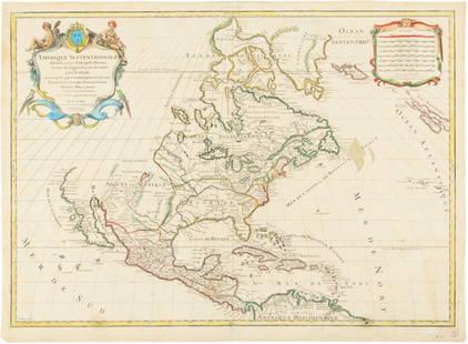
Sold2015Map of North America 1719Heading: (North America) Author: Sanson, Nicolas/ Hubert Jaillot Title: Amerique Septentrionale divisée en ses Principales Parties, ou sont distingués les uns des autres les Estats suivant quils appSee Sold Price
Sold2022Scarce 1705 map of North America by Nicolas de Fer (Calif. as island)Nice example of de Fer's scarce map of North America, first published in Paris in 1693. This specimen with a 1705 date is from the 1723 edition of de Fer’s Petit et Nouveau Atlas and features laterSee Sold Price
Sold2019Franklin Mint Sterling Silver Map of North America LEFranklin Mint limited edition (1000) "A New Map of America Septentrionale" sterling silver map, etched details, 14" x 19.5", from the Franklin Mint ArchiveSee Sold Price
Sold2018Sanson: North Africa / Patriarchate of Alexandria, 1730Partriarchatus Alexandrini Geographica descriptio The later Covens & Mortier edition of Sanson's map of the Patriarchate of Alexandria encompassing Libya and Egypt, with great detail and many place naSee Sold Price
Sold2018General Map of North America from the Best AuthoritiesTitle/Content of Map: General Map of North America from the Best Authorities Date Printed: 1796 Cartographer: MORSE, JEDIDIAH Size: 7.3X8.75 "Engraved for third edition of Morse's Universal Geography:See Sold Price
Sold2024Rare Antique Map - Hudson Bay Chart - Old Map of North America - Bellin - Jacques"Carte de la Baye de Hudson". Its finely engraved, hand-coloring engraved map from the Dutch edition of acques Nicolas Bellin Histoire "General of Travel". Published in Amsterdam. A handsome chart ofSee Sold Price
Sold20201801 Map of North AmericaAuthor: Walker Title: 1801 Map of North America Medium: Ink on PaperDimensions: 10"X8.5" Map of North America dated 1801. Part of the 3rd edition of the Universal Gazetteer. Published by John Walker iSee Sold Price
Sold2022Antique Map Print - North America - Africa - South America - WorldSet of 4 Map Prints. Hand-colored map print of the edition of 1851 from the work Universal Historical and Geographical Atlas ("Atlas Universel Historique et Geographique"). This iconic map contains diSee Sold Price
Sold2022Great Colton map of IowaAn excellent 1855 first edition example of Colton's map of Iowa. Like most of Colton's state maps, this map was derived from an earlier wall map of North America produced by Colton and D. Griffing JohSee Sold Price
Sold20231841 Statistical Map Democracy in America Tocqueville(Tocqueville, Alexis de), Statistical Map of North America to illustrate M. de Tocqueville's Democracy in America with the Census of 1840, printed to accompany J and H. G. Langley's 1841 edition of thSee Sold Price
Sold2018Antique Hand Colored Maps of The AmericasAntique Hand Colored Maps of The Americas. This lot features two 19th century hand colored maps of North America and South America from the Carey and Lee Atlas American Edition 1823-24. Both maps areSee Sold Price
Sold20241719 Map of Colonial era North America, by Sanson - JaillotTitle: 1719 Map of Colonial era North America, by Sanson - Jaillot Date/Period: 1719 Materials: Copperplate engraved Size: 25 1/2 x 18” This map is a rare and valuable map of history, showing NoSee Sold Price
Sold20171821 Carey & Lea Map of North and South America1821 Carey & Lea map of North and South America. 1821 Geographical, Historical, and Statistical Map of America. from the third Philadelphia Edition. Printed by T. H. Palmer for M. Carey & Son, from thSee Sold Price
Sold2022Lizars, Daniel 1831 LG Rare HC Map. Atlantic Ocean showing North AmericaLarge Folio Copper Engraved Map Published 1831-2 by John Hamilton, Successor to Daniel Lizars, Edinburgh for "The Edinburgh Geographical and Historical Atlas..." First Edition by Daniel Lizars. Very fSee Sold Price
Sold2017Map of British Possessions in North America, 1805[Carey and Lea?] British Possessions in North America c1805 copper-engraved map, hand-coloured Place Published: [Philadelphia?] Date Published: [1805] Edition: 1st Edition Binding: No binding Date: [cSee Sold Price
Sold2021North America.Publication Date: c1818 Title: North America. Cartographer: ANONYMOUS Publisher: SAMUEL F. BRADFORD Height: 9.5 Width: 15.25 Illustration map from the first American edition of Rees's Encyclopaedia. ESee Sold Price
Sold2020Fireside Travels in North AmericaBy James A Fritzpatrick, Maps by V.A. Seward, First Edition, 1948See Sold Price
Sold2019USA 1911 Lot of 5 Maps from The Encyclopedia BritannicaNorth America, plus 4 State Maps - Wisconsin, Ohio, New Hampshire/Vermont, and New York. Lithograph Maps Published 1911, New York for "The Encyclopaedia Britannica" 11th Edition by Various ContributorSee Sold Price
7 days LeftTrillium Antique Prints & Rare BooksSanson - Map of North America with California as an Island$75(1 bid)
5 days LeftHolabird Western Americana CollectionsEarly California Voyagers (2 Books) 1933, 1927 [182272]$75
6 days LeftFreeman's | HindmanHARMON, Daniel Williams. A Journal of Voyages and Travels in the Interiour of North America. 1820.$450(2 bids)
152 Lots AwayBritannica Auctions LtdNuttall's Hare - Rare Imperial Folio by JW Audubon 1846£360(1 bid)
3 days LeftJasper521761 NEW DICTIONARY OF TRADE & COMMERCE R. ROLT antique FOLIO ILLUSTRATED w/MAPS$440
7 days LeftTrillium Antique Prints & Rare BooksAudubon, Imperial Folio - Rocky Mountain Sheep. 73$375
7 days LeftTrillium Antique Prints & Rare BooksAudubon, Imperial Folio - PAIR of Lithographs (Marmot Squirrel & Spermophile)$375


![Map of British Possessions in North America, 1805: [Carey and Lea?] British Possessions in North America c1805 copper-engraved map, hand-coloured Place Published: [Philadelphia?] Date Published: [1805] Edition: 1st Edition Binding: No binding Date: [c](https://p1.liveauctioneers.com/5584/100357/51204043_1_x.jpg?height=310&quality=70&version=1487374747)


![Early California Voyagers (2 Books) 1933, 1927 [182272] (1 of 9)](https://p1.liveauctioneers.com/2699/331494/178785429_1_x.jpg?height=282&quality=70&version=1717094654)


