Sold2024Marmocchi, F. C. 1845 Hand Col Map. Egypt Pharaoh Empire, David SalomonFolio Hand Colored Etching/Engraving Published 1845, Florence for "Atlante di Geografia-Storica Universale" by Francesco C. Marmocchi. Paper Size: 17 x 11 inch (43 x 28cm) ome toning, otherwise Good CSee Sold Price
Sold2024Marmocchi, F. C. 1845 Hand Col Map. Holy Land. Persia Empire, Alexander the GreatFolio Hand Colored Etching/Engraving Published 1845, Florence for "Atlante di Geografia-Storica Universale" by Francesco C. Marmocchi. Paper Size: 17 x 11 inch (43 x 28cm) Good ConditionSee Sold Price
Sold2024Marmocchi, F. C. 1845 Hand Col Map. Arabia, Syria, Cyprus, Crete, Egypt"Siria Cipro, Creta Egitto Cirenaica Marmarica ed Arabia Carta di Geografica Antica" Folio Hand Colored Etching/Engraving Published 1845, Florence for "Atlante di Geografia-Storica Universale" by FranSee Sold Price
Sold2024Marmocchi, F. C. 1845 Hand Col Map. Mediterranean"Carta dell' Italia dell' Africa della Numidia?." Folio Hand Colored Etching/Engraving Published 1845, Florence for "Atlante di Geografia-Storica Universale" by Francesco C. Marmocchi. Centre fold asSee Sold Price
Sold2024Marmocchi, F. C. 1845 Hand Col Map. Ancient Italy"L'Italia Antica" Folio Hand Colored Etching/Engraving Published 1845, Florence for "Atlante di Geografia-Storica Universale" by Francesco C. Marmocchi. Folds as issued. Paper Size: 27.5 x 21 inch (71See Sold Price
Sold2024Marmocchi, F. C. 1845 Hand Col Map. Holy Land. Canaan. Israel PalestineFolio Hand Colored Etching/Engraving Published 1845, Florence for "Atlante di Geografia-Storica Universale" by Francesco C. Marmocchi. Paper Size: 17 x 11 inch (43 x 28cm) Good ConditionSee Sold Price
Sold2024Marmocchi, F. C. 1845 Hand Col Map. Greek Colonies. Ancient Greece"Carta delle Colonie Greche" Folio Hand Colored Etching/Engraving Published 1845, Florence for "Atlante di Geografia-Storica Universale" by Francesco C. Marmocchi. Paper Size: 17 x 11 inch (43 x 28cm)See Sold Price
Sold2024Marmocchi, F. C. 1845 Hand Col Map. Greece - Ancient Attica & LaconiaFolio Hand Colored Etching/Engraving Published 1845, Florence for "Atlante di Geografia-Storica Universale" by Francesco C. Marmocchi. Paper Size: 17 x 11 inch (43 x 28cm) Good ConditionSee Sold Price
Sold2024Marmocchi, F. C. 1845 Hand Col Map. Europe Political Map"Prospetto Geografico Politico della Gallia della Germania della Bretagna della Ibernia" Folio Hand Colored Etching/Engraving Published 1845, Florence for "Atlante di Geografia-Storica Universale" bySee Sold Price
Sold2024Marmocchi, F. C. 1845 Hand Col Map. Asia Minor. Macedonia Greece CyprusFolio Hand Colored Etching/Engraving Published 1845, Florence for "Atlante di Geografia-Storica Universale" by Francesco C. Marmocchi. Paper Size: 17 x 11 inch (43 x 28cm) Good ConditionSee Sold Price
Sold2024Marmocchi, F. C. 1845 Hand Col Map. Ancient Greece"La Grecia Antica" Folio Hand Colored Etching/Engraving Published 1845, Florence for "Atlante di Geografia-Storica Universale" by Francesco C. Marmocchi. Paper Size: 17 x 11 inch (43 x 28cm) Very minoSee Sold Price
Sold2024Marmocchi, F. C. 1845 Hand Col Map. Holy Land. Israel, Jerusalem insetFolio Hand Colored Etching/Engraving Published 1845, Florence for "Atlante di Geografia-Storica Universale" by Francesco C. Marmocchi. Paper Size: 17 x 11 inch (43 x 28cm) Good ConditionSee Sold Price
Sold2024Marmocchi, F. C. 1845 Hand Col Map. Ancient World"Mondo Conosciuto dagli Antichi" Folio Hand Colored Etching/Engraving Published 1845, Florence for "Atlante di Geografia-Storica Universale" by Francesco C. Marmocchi. Folds as issued. Paper Size: 22See Sold Price
Sold2024Marmocchi, F. C. 1845 Hand Col Map. Black Sea. Greece Armenia Turkey Russia"Carta del Reame di Mitridate il Grande della Grecia dell' Aermenia..." Folio Hand Colored Etching/Engraving Published 1845, Florence for "Atlante di Geografia-Storica Universale" by Francesco C. MarmSee Sold Price
Sold2021c 1730 Seutter Map: Novi Belgii, in America ...Historic Maps c. 1730 Historic Rare Earlier State of Seutter's Important American Northeast Map & New York City Restitutio View c. 1730 Hand-Colored Copper-Engraved Map titled, "Recens Edita totius NoSee Sold Price
Sold2022Ortelius, Abraham Islandia [Iceland]Ortelius, Abraham Islandia [Iceland] [Antwerp, c.1590 or later]. Hand-coloured engraved map (platemark 33.5 x 48.5cm, sheet size 43.5 x 55.5cm), incorporating sea-monsters, polar bears and Hekla volcaSee Sold Price
Sold2020Original Map, Nantucket Drawn by Rev F.C. Ewer, 1869Original Historical Map of Nantucket Surveyed and Drawn by Reverend F.C. Ewer D.D., 1869, (Ferdinand Cartwright 1826-1883) mounted on canvas, unframed. 12 ¾ in. x 20 in.See Sold Price
Sold2024*EXCLUSIVE* Hand Marked "Unc Peace Standard," x20 coin Covered End Roll! - Huge Vault Hoard (FC)*EXCLUSIVE* Hand Marked "Unc Peace Standard," x20 coin Covered End Roll! - Huge Vault Hoard (FC). Up for auction is a (20 coin roll marked “Unc Peace Standard” and having two covered ends andSee Sold Price
Sold2023Greece.- Dodwell (Edward) Views in Greece, from Drawings, first edition, Rodwell and Martin, 1821.Greece.- Dodwell (Edward) Views in Greece, from Drawings, first edition, deluxe issue, title with aquatint vignette, 30 superb hand-coloured aquatint plates by R. Havell, T. Fielding, F.C. Lewis and oSee Sold Price
2022Blaeu, Johannes (Netherlands, 1596-1673) "The New World Map" Double Hemisphere World Map C. 1664Nova et Accuratissima Totius Terrarum Orbis Tabula Translated "The New World Map", Hand Colored w/ Elaborately Decorated Spandrels.   Sight View 16" x 21-1/2", Overall View 21" x 25-1/2"See Sold Price
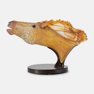
Sold2022David Bennett (American, b. 1941) Horse Head Sculpture, c. 2000David Bennett (American, b. 1941) Horse Head Sculpture, c. 2000 hand-blown glass, steel H 19 x W 30 x D 12 inches. Property from the Collection of Robert P. Hunter, Jr. and Barbara Hunter, Alpharetta,See Sold Price
Sold2023Important lot 18th c documents from Hurley New York, many signatures of the significant families inImportant lot 18th c documents from Hurley New York, many signatures of the significant families in Ulster County, also hand drawn maps, stamped seals and small box of fragments of manuscripts and docSee Sold Price
Sold2022Colom's Map of the Western Indian Ocean, c. 1658COLOM, Arnold (1624-1668). Oost Indien van Cabo de Bona Esperanca tot Ceilon. Engraved map with original hand color in outline. Amsterdam, c. 1658. 22 1/4" x 25 1/2" sheet. Colom's Zee Atlas is amongSee Sold Price
Sold2023Marius Jean Antonin Mercié (French, 1845–1916) David VainqueurMarius Jean Antonin Mercié (French, 1845–1916) David Vainqueur Signed 'A. Mercie' on the base; also with 'F. BARBEDIENNE. FONDEUR.PARIS' foundry stamp along the rim and with 'RéductionSee Sold Price
15 hrs LeftGold Coast Auctioneers17th-19th c. French Wall Art Collection Map City Sea Scapes Scenes etc.$50
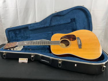
Crawford Family Auctions LLCMartin & Co. D-93 1993 Acoustic Guitar, needs work w/ Martin branded Hard Case$1,100(8 bids)
Jun 15Hess Fine AuctionsEastman MD615-SB Hand Made Electric F-Style Mandolin c. 2011 with Gig Bag$350(5 bids)
Jun 13Alderfer AuctionPair of Ancient Coins-Roman Empire Antoninus Pius Silver Denarius and Roman Empire Trebonianus$100
18 hrs LeftTaylor & HarrisFurstenberg German Hand Painted Porcelain Topographical Tea Caddy c. 1800$150
5 days LeftFreeman's | HindmanTHOREAU, Henry David (1817-1862). The Writings. Boston and New York: Houghton Mifflin and Company,$2,500


![Ortelius, Abraham Islandia [Iceland]: Ortelius, Abraham Islandia [Iceland] [Antwerp, c.1590 or later]. Hand-coloured engraved map (platemark 33.5 x 48.5cm, sheet size 43.5 x 55.5cm), incorporating sea-monsters, polar bears and Hekla volca](https://p1.liveauctioneers.com/94/251108/130828919_1_x.jpg?height=310&quality=70&version=1655281539)


![[MAP]. SPEED, John. A New Mappe of the Romane Empire. 1676. (1 of 2)](https://p1.liveauctioneers.com/197/329395/177650541_1_x.jpg?height=282&quality=70&version=1715364962)

![[MAP]. ORTELIUS, Abraham. Turcici Imperii Descriptio.1592. (1 of 2)](https://p1.liveauctioneers.com/197/329395/177650538_1_x.jpg?height=282&quality=70&version=1715364962)
![[MAP]. ORTELIUS, Abraham. Romani Imperii Imago. 1592. (1 of 2)](https://p1.liveauctioneers.com/197/329395/177650537_1_x.jpg?height=282&quality=70&version=1715364962)


