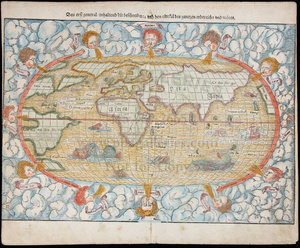
Sold2023Munster map of World 1550Heading: (Maps) Author: Münster, Sebastian Title: Das Erst General/inhaltend die beschzeibung und den Circkeldes gantzen Erdtrichs und Moze Place Published: [Basle] Publisher: Date Published: </See Sold Price
Sold2020Sebastian Munster Map of Paris 1550Sebastian Munster (1488-1552), "La ville de Paris, par tout tant renommee, & principalle ville du royaulme de France," ca. 1568. This hand-colored woodcut map of Paris shows the city from a birdseye vSee Sold Price
Sold20221550 Munster Map of Sicily -- SiciliaTitle: 1550 Munster Map of Sicily -- Sicilia Cartographer: S Munster Year / Place: 1550, Basel Map Dimension (in.): 8.4 X 5.8 in. This is an superb woodblock map of Sicily. North orients to the left.See Sold Price
Sold20221550 Munster Map of Holy Land and Cyprus -- [Holy Land and Cyprus]Title: 1550 Munster Map of Holy Land and Cyprus -- [Holy Land and Cyprus] Cartographer: S Munster Year / Place: 1550, Basel Map Dimension (in.): 10.8 X 6.7 in. This a superb woodblock map of the HolySee Sold Price
Sold20221550 Munster Map of Southern Italy or Kingdom og Naples -- Regnu NeapolitaTitle: 1550 Munster Map of Southern Italy or Kingdom og Naples -- Regnu Neapolita Cartographer: S Munster Year / Place: 1550, Basel Map Dimension (in.): 8.1 X 5.8 in. This is an excellent woodblock maSee Sold Price
Sold20231550 Munster Map of Sardinia -- Sardinia InsulaTitle: 1550 Munster Map of Sardinia -- Sardinia Insula Cartographer: S Munster Year / Place: 1550, Basel Map Dimension (in.): 10.1 X 6 in. This is a charming woodblock map of Sardinia. The towns and cSee Sold Price
Sold2017Munster: Antique Map Plan of Cusco, 1550Map: Die Statt Cusco Cartographer: Sebastian Munster Place & Date: Basle / 1550 Size: 14 3/4" x 10 5/8" Condition: B&W; overall age toning; some browning along centerfold and outer edges of margins; aSee Sold Price
Sold2023Sebastian Munster - 16th Century Ptolemaic Map of the WorldSebastian Munster (1488-1552), Ptolemeisch General Tafel/die halbe kugel der Welt begreiffende, Basel, circa 1578, decorative border with twelve headwinds, engraving on laid paper with hand color, sheSee Sold Price
Sold2017Munster: Antique Map of the Iberian Peninsula, 1550Title: Tabula Europae II, Lovely mid-16th century woodblock map of the Iberian Peninsula Map maker: Sebastian Münster, Cosmographiae Universalis... Place and Year: Basel, c. 1550 Dimensions: 35.3 x 2See Sold Price
Sold2017Munster: Map of Inca Capital of Cusco, 1550Map: Die Statt Cusco Cartographer: Sebastian Munster Place & Date: Basle / 1550 Size: 14 3/4" x 10 5/8" The magnificent view of the ancient Inca capital of Cusco from Münster's influential CosmographSee Sold Price
Sold2023MAP, Germany, MunsterSouthern Germany. Sebastian Munster, Das Algow, from Cosmographey oder Beschreibung Aller Laender, 1578 (published). Hand Color. This charming woodblock map of southwestern Bavaria oriented with northSee Sold Price
Sold2024MAP, Balkans, MunsterIstria Peninsula, Croatia. Sebastian Munster, [Title on Verso] Hysterreich, from Cosmographei oder Beschreibung aller Länder, 1556 (published). Hand Color. Woodblock map of Istria, in present-day CroSee Sold Price
Sold2021Sebastian Munster (German, 1488-1552) - Holy Land andSebastian Munster (German, 1488-1552) - Holy Land and Cyprus Map, Woodcut, Circa 1550. Hand colored woodcut. Printed in Basle by Petri. Sheet: 31.5x19.5cm. Plate: 26.5x16.5cm.See Sold Price
Sold2020MÜNSTER, SEBASTIAN. Die Erst General Tafel / DieMÜNSTER, SEBASTIAN. Die Erst General Tafel / Die Beschreibung und den Circkel des Gantzen Erdtrichs und Deers Innhaltende. Double-page woodcut map of the world within a foliate border design. 14xSee Sold Price
Sold2022World.- Münster (Sebastian) Figura del Mondo Universale, [c. 1575].World.- Münster (Sebastian) Figura del Mondo Universale, Ptolemaic woodcut map of the ancient world, prior to the discovery of the New World with an enclosed Indian Ocean and multiple lake sourceSee Sold Price
Sold2016Munster DES NOUVELLES ISLES. Woodcut map.[New World] DES NOUVELLES ISLES, COMMENT, QUAND & PAR QUI ELLES ONT ESTE TROUVEES. Woodcut map from Sebastian Munster’s “Cosmographia…” Text below woodcut and on verso. Several French editionsSee Sold Price
Sold2016Bavaria / Southern Germany c. 1550Map Title: Sveviae Et Bavariae Descriptio Published: Munster, S., Basel Date: c. 1550 Size: 10 5/8 x 13 1/2 inches. An attractive early woodcut map of Bavaria/ Southern Germany. A picturesque, early wSee Sold Price
Sold2022MAP, World, BellinWorld. Jacques Nicolas Bellin, Carte Reduite des Parties Connues du Globe Terrestre Dressee au Depost des Cartes Plans et Journaux de la Marine..., 1755 (dated). Hand Color. This is the rare first ediSee Sold Price
Sold20211628 Munster Map of Africa -- Africae Tabula NovaTitle: 1628 Munster Map of Africa -- Africae Tabula Nova Cartographer: S Munster Year/Place: 1628, Petri Map Dimensions (in.): 12.1 X 14.2 in. Description: This is a superb double-page woodblock map oSee Sold Price
Sold20211598 Munster Map of the Middle East -- Syria / Cypern /Title: 1598 Munster Map of the Middle East -- Syria / Cypern / Palestina / Mesopotamia / Babylonia / zwey Arabia / mit Bergen / Waesseren und Stetten Cartographer: S Munster Year / Place: 1598 c., BasSee Sold Price
Sold20231939 Chase World Pictorial Map - World Wonders A Pictorial Map Designed and drawn by Ernest DudleyTitle: 1939 Chase World Pictorial Map - World Wonders A Pictorial Map Designed and drawn by Ernest Dudley Chase Cartographer: E D Chase Year / Place: 1939 Map Dimension (in.): 27.5 X 17.5 in. This supSee Sold Price
Sold20231552 Munster Map of Northern Greece and Balkans -- Tabula Europae IXTitle: 1552 Munster Map of Northern Greece and Balkans -- Tabula Europae IX Cartographer: Munster / Ptolemy Year / Place: 1552. Basel Map Dimension (in.): 11 X 13.5 in. This is fantastic, somewhat rarSee Sold Price
Sold20231564 Munster Map of Central Europe, Centered on Germany -- Teutschland mit Seinem Gantzen BegriffTitle: 1564 Munster Map of Central Europe, Centered on Germany -- Teutschland mit Seinem Gantzen Begriff und Eingeschlossnen Landschafften Cartographer: S Munster Year / Place: 1564, Basel Map DimensiSee Sold Price
Sold20211598 Munster Map of Czech Republic -- BohemerTitle: 1598 Munster Map of Czech Republic -- Bohemer Koenigreich mit Bergen und Waelden gerings umb beschlossen Cartographer: S Munster Year / Place: 1598 c., Basel Map Dimension (in.): 12.1 X 14.1 inSee Sold Price
6 days LeftTrillium Antique Prints & Rare BooksMunster, pub. 1614 - Diagram of Horizon, Parallels, et al.$50
6 days LeftTrillium Antique Prints & Rare BooksMunster, pub. 1614 - View of Tours in Touraine, France$50
6 days LeftTrillium Antique Prints & Rare BooksMunster, pub. 1614 - View of Sion (Sitten), Switzerland$50
Jun 23Eagles Corps International LLC1937 Mickey Mouse Globe Trotters World Map and Cards RARE$200(1 bid)
2 days LeftJasper521788 Gravius World Map -- Kaart van de Geheele Wereld na de Alderlaatste Ontdekkingen$130
Jun 25Freeman's | Hindman[Early Printing] [Incunable] (Macrobius, Ambrosius Aurelius Theodosius: In Somnium Scipionis exposit$300


![Munster map of World 1550: Heading: (Maps) Author: Münster, Sebastian Title: Das Erst General/inhaltend die beschzeibung und den Circkeldes gantzen Erdtrichs und Moze Place Published: [Basle] Publisher: Date Published: </](https://p1.liveauctioneers.com/642/299378/159362943_1_x.jpg?height=310&quality=70&version=1692570425)


![1550 Munster Map of Holy Land and Cyprus -- [Holy Land and Cyprus]: Title: 1550 Munster Map of Holy Land and Cyprus -- [Holy Land and Cyprus] Cartographer: S Munster Year / Place: 1550, Basel Map Dimension (in.): 10.8 X 6.7 in. This a superb woodblock map of the Holy](https://p1.liveauctioneers.com/5584/265564/138674312_1_x.jpg?height=310&quality=70&version=1666735666)


![MAP, Balkans, Munster: Istria Peninsula, Croatia. Sebastian Munster, [Title on Verso] Hysterreich, from Cosmographei oder Beschreibung aller Länder, 1556 (published). Hand Color. Woodblock map of Istria, in present-day Cro](https://p1.liveauctioneers.com/6576/320593/172252548_1_x.jpg?height=310&quality=70&version=1708729193)


![World.- Münster (Sebastian) Figura del Mondo Universale, [c. 1575].: World.- Münster (Sebastian) Figura del Mondo Universale, Ptolemaic woodcut map of the ancient world, prior to the discovery of the New World with an enclosed Indian Ocean and multiple lake source](https://p1.liveauctioneers.com/5458/260724/135800515_1_x.jpg?height=310&quality=70&version=1662479034)
![Munster DES NOUVELLES ISLES. Woodcut map.: [New World] DES NOUVELLES ISLES, COMMENT, QUAND & PAR QUI ELLES ONT ESTE TROUVEES. Woodcut map from Sebastian Munster’s “Cosmographia…” Text below woodcut and on verso. Several French editions](https://p1.liveauctioneers.com/179/85723/44107983_1_x.jpg?height=310&quality=70&version=1456876561)


![[Early Printing] [Incunable] (Macrobius, Ambrosius Aurelius Theodosius: In Somnium Scipionis exposit (1 of 3)](https://p1.liveauctioneers.com/65/332523/179335062_1_x.jpg?height=282&quality=70&version=1717709446)