Sold2018Portolan Chart of SicilyIlluminated manuscript portolan chart on vellum of Sicily “Isola. D. Sicilia”. Jouanne Oliva (fl. 1570-1614). Marseilles, 1600. Single leaf of vellum, float-mounted and framed. 20 x 28 inches sheeSee Sold Price
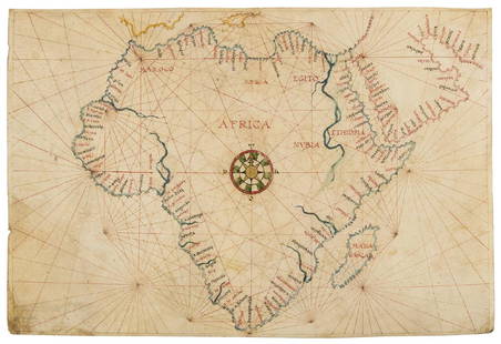
Sold2019Africa.- Agnese (Manner of Battista, c.1500-1564)Africa.- Agnese (Manner of Battista, c.1500-1564) Portolan chart of Africa and the Arabian Peninsula, large compass rose with port towns and cities annotated, pen and inks, watercolour wash, heighteneSee Sold Price
Sold2017Maps, Charts, Globes: Five Centuries of ExplorationTitle: Maps, Charts, Globes: Five Centuries of Exploration. A New Edition of E.L. Stevenson's Portolan Charts and Catalogue of the 1992 Exhibition New York. The Hispanic Society of America. 1992 AuthoSee Sold Price
Sold2017De Wit Portolan Sea Chart of EuropeTotius Europae Victoria... Frederic De Wit (1630-1706). Engraved map with original hand color. Amsterdam, 1675. 20 x 35 1/2 inches sheet, 27 1/2 x 43 inches framed. “The most striking and decorativeSee Sold Price
Sold2018Mount & Page: Antique Map of Palermo in Sicily, 1747Title/Content of Map: 'The haven of Palermo in Sicily' sea chart & town plan Date Printed: 1747 Image Size: Approx 11.0 x 23.0cm, 4.25 x 9 inches (Medium) Type: Antique 18th century copperplate map CoSee Sold Price
Sold2023Large chart of Pacific & Indian Oceans 1813Heading: Author: Espinosa y Tello, Josef Title: Carta general para las navegaciones a la India Oriental por el Mar del Sur y el Grande Oceano que separa el Asia de la America Place Published: LondonSee Sold Price
Sold2022RAOUL DUFY (Le Havre, 1877- near Forcalquier, 1953). "Landscape of Sicily", 1922. Watercolor andRAOUL DUFY (Le Havre, 1877 - near Forcalquier, 1953). "Landscape of Sicily", 1922. Watercolour and gouache on paper. Work reproduced in the Catalogue raisonné of the artist Aquarelles et gouaches-SSee Sold Price
Sold2024Ancient Greek, Sicily Terracotta Comic Theater Mask. c.5th century BC.Ancient Greek, Sicily Terracotta Comic Theater Mask c5th-century BC. ?Size: 7 inches high, 5 1/2 inches wide.Ancient Greek Sicily terracotta comic theater mask, dating back to the 5th century BC. thisSee Sold Price
Sold2022A Superb Circular Bronze Gold& Silver-Inlaid 'Astrological Chart' MirrorA Superb Circular Bronze Gold& Silver-Inlaid 'Astrological Chart' Mirror. From The Ancient Times. Size:40cmSee Sold Price
Sold2022Sister Gertrude Morgan. Revelation Chart.Sister Gertrude Morgan. (1900-1980, Alabama, Louisiana) Revelation Chart. Signed and titled. Paint and ink on found cardstock. Excellent condition. Vivid bright colors. 12"w x 6"h. 18.5"w x 12.5"h witSee Sold Price
Sold2023Howard Finster. Chart of Time By Vision Divine, #1,819.Howard Finster. Chart of Time By Vision Divine, #1,819. 1980. Signed, dated, titled, numbered. Enamel on Mason TV side. Excellent condition. 24" w x 18.5" h including artist-made wood-burned frame. PrSee Sold Price
Sold2022A Delicate Blue And White Figure War General Chart Brush PotA Delicate Blue And White Figure War General Chart Brush Pot From Qing DynastySize: 21.5cmx20.2cmSee Sold Price
Sold2022Polarine "Consult Chart" Porcelain Signrate 9+, 30" Diameter, Double sided porcelain sign w/ excellent color and gloss, shows minute to chipping to one mounting hole and a few edge nicks, the is one of the nicest examples you will find ofSee Sold Price
Sold2022ARROWSMITH, AARON. Chart of the Pacific Ocean.ARROWSMITH, AARON. Chart of the Pacific Ocean. Large engraved navigational chart of the coastlines of Russia, Japan, Korea, China, the Philippines, Indonesia, and Australia. 73¼x31½ inches oSee Sold Price
Sold2022LARGE ARCHITECTS PRINT / MAP / CHART CABINETFantastic very large Architectural draftsman/chart/map/print flat file - George III-Style mahogany with satinwood inlay, inset tooled leather top. 8 Drawer over 4 drawer. from the Audubon Gallery, KinSee Sold Price
Sold2019A View of Agrigento, Sicily, Oil on Canvas19th century American School, a view of Agrigento, Sicily, oil on canvas, inscribed 'Agrigento Sicilia' and dated '1856', in later frame, 33 1/4" x 43 1/4", frame 42" x 52".See Sold Price
Sold2021Tian Shizu mark: Flower Bird Chart PaintingTian Shizu mark: Flower Bird Chart Painting. Length: 103 cm; Width: 38 cm. Provenance: Private artist collection, Monterey Park, California, USA.See Sold Price
Sold2022Sicily. Syracuse. Agathocles, ca. 317-289 BC. ARSicily. Syracuse. Agathocles, ca. 317-289 BC. AR Tetradrachm (17.2g), period 2, ca. 305 BC. ACNAC 6, Dewing 943. Obverse: Head of Arethusa left, four dolphins swimming around. Reverse: Charioteer drivSee Sold Price
Sold2020Tibetan Astrological Chart Fortune Teller ScrollFortune Teller's Scroll or Astrological Chart of Manjushri System, Tibet, 19th century, gouache on cotton with fabric sides and wooden handle, 13 x 50.5 inches, in a cherry wood frame 22 x 58.5 inchesSee Sold Price
Sold2020World.- Purdy (John, hydrographer) A Chart of theWorld.- Purdy (John) A Chart of the World, on Mercator's Projection; with the Tracks of the more Distinguished Modern Navigators. Regulated throughout, according to the best Scientific Determinations,See Sold Price
Sold2023De Eylanden van Pehou' by VAN KEULEN. Penghu Islands Taiwan. VOC chart 1753 mapTitle: De Eylanden van Pehou' by VAN KEULEN. Penghu Islands Taiwan. VOC chart 1753 map Description: De Eylanden van Pehou' by Johannes van Keulen (1753). Early 18th century Dutch sea chart with old coSee Sold Price
Sold2022(NORTHWEST PASSAGE -- THE SEARCH FOR FRANKLIN.) Chart of the North-West Passage(NORTHWEST PASSAGE -- THE SEARCH FOR FRANKLIN.) Chart of the North-West Passage Discovered by Capt. McClure H.M.S. Investigator 1850-1853... Third Edition with the Discoveries of the American Arctic ESee Sold Price
Sold2023British Admiralty Chart #1917 - Van. Isl & Gulf of Georgia, Ex. Coll Admiral Nelles, 25".British Admiralty Chart #1917 - Van. Isl & Gulf of Georgia, Ex. Coll Admiral Nelles, 25".See Sold Price
3 days LeftDOYLE Auctioneers & AppraisersTerracotta Statue of a Man Smoking a Pipe Sicily, 19th Century$200
4 days LeftJasper52Africae / Africa by Bertius / Langenes 1603 old antique vintage map plan chart$260
37 mins LeftTrillium Antique Prints & Rare BooksPrevost - Chart of the Islands of Java, Sumatra, Borneo, &c.$50
3 days LeftJasper52Track Chart of Cruise of U.S. Rev. Steamer "Bear" and Overland Expedition to the Relief Of Whalers$60
Jun 28Rail & Road AuctionsLouisville and Nashville Railroad Paper Group - Track Chart, Magazine, Mailing Envelopes, and More$20
3 days LeftJasper52Chart Showing the Distribution of the Principal Minerals in The Countries of The World.$30
37 mins LeftTrillium Antique Prints & Rare BooksDobson - Map of the World with Chart of Torrid Zone or Tropical Regions of the World$50