Sold2022Maps and Views, Documents, 1856-1857Map and Views to Accompany Message and Documents 1856-7, Washington, D.C. 1856, maps of Minnesota, California and New Mexico, etc. Provenance: Andover, Massachusetts collection.See Sold Price
Sold2016Rare. 17th Century German View Book.Johann Curicke. Der Stadt Danzig. 1688 Appears complete with all fold outs and front folding map. Original Calf. Nice volume.See Sold Price
Sold2020Grp: 6 Maps of Europe by Braun & HogenbergGroup of six maps by Georg Braun (1541–1622) and Frans Hogenberg (1540–1590) including maps of Ghent, Odense in Denmark originally for the book "Civitates Orbis Terrarum", a map of ParisSee Sold Price
Sold2017Hokusai Katsushika Woodblock 100 Mt Fuji Vol.1, 2 and 3Artist: Hokusai Katsushika Title: 100 Famous Views of Mt Fuji Vol.1, 2 and 3 (with commentary book) Publisher: Iwasaki Bijutsu-sha Date: Showa era Medium: Japanese Woodblock print Size: Each book: 6.3See Sold Price
Sold2024Antique Woodcut - Map of Venezia - Panoramic Bird's-Eye View - Hartmann SchedelThis beautiful color woodcut is an illustration from The Nuremberg Chronicle, a monumental and beautifully illustrated book of world history by Hartmann Schedel, Illustrated by Wilhelm Hans PleidenwurSee Sold Price
Sold2021ARCTIC: PARRY'S FIRST VOYAGE, W/ MAPS, 1821ARCTIC EXPLORATION. Rear Admiral William Edward Parry (1790-1855). PARRY'S FIRST VOYAGE. 1st edition book (1821), bound with the 1824 supplement, containing an account of the subjects of Natural HistoSee Sold Price
Sold2022Miscellaneous books a large quantityMiscellaneous books a large quantity including: Jones, Owen, chromolithographer. The Book of Common Prayer. London: J. Murray, 1855. 8vo, (185 x 255mm), title and 6 chromolithographed plates, text witSee Sold Price
Sold2024Kohler & Weigel - Map of the World with North and South Pole viewsThis originally hand-colored engraving is from Johnn David Kohler's Schul- und Reisen-Atlas aller zu Erlernung der alten, mittlern und neuen Geographie dienlichen Universal- und Particular-Charten...See Sold Price
Sold2023John Bachmann, "Bird's Eye View: Texas and Part of Mexico"John Bachmann (Amer., 19th C.), "Bird's Eye View: Texas and Part of Mexico", from the series "Panorama of the Seat of War", (6) chromolithographic maps of Confederate states in panSee Sold Price
Sold20201802 Denon Atlas of Egypt Containing Maps, Views, etc.Title: 1802 Denon Atlas of Egypt Containing Maps, Views, etc. -- Planches du voyage dans la Basse et la Haute Egypte Date: 1802 c., Paris Cartographer: D-V Denon Size: 18.2 X 11.4 in. and lagest foldoSee Sold Price
Sold2015(6) BOOKS OF JAPANESE UKIYO-E WOODBLOCK PRINTS - All(6) BOOKS OF JAPANESE UKIYO-E WOODBLOCK PRINTS - All 19th c, bound in the Japanese style, including: designs for kimono cloth, tigers and leopards, anthropomorphic cats, geishas with cats, and fire coSee Sold Price
Sold20221833 Jos. Perkins A New General Atlas Map Book1833, written and engraved by Jos. Perkins, publisher - Anthony FinleySee Sold Price
Sold2022Rosewood tester bed, attrib. to Prudent MallardPrudent Mallard three quarter tester Rosewood plantation bed with elaborate carved crowns and mosquito net poles, ca. 1855, 6 ft. W, 77 in. L, 10 ft. 5 in. T.See Sold Price
Sold2024AHMED SHIBRAIN (SUDANESE, 1931-2017).'Message 6'. Ink and watercolor on paper. Signed in Arabic top center. Verso: Titled. From a Mamaroneck, NY estate. Dimensions: 22.75" h x 15.5" w. Frame: 30" h x 22" w.See Sold Price
Sold2024Roberts, David 1856 Print. Obelisk of On 197Lithograph Published 1855-6 by Day & Son, London for "The Holy Land, Syria, Idumea, Arabia, Egypt & Nubia" Second Edition (First Quarto Edition) by David Roberts. Paper Size: 11.5 x 8 inch (29 x 20cm)See Sold Price
Sold201818th C. Spanish Oil, Map of the Siege of BarcelonaContinental School, likely Spanish, late 18th century Overhead landscape painting depicting a stylized map view of Barcelona as seen in 1705, bearing inscription loosely translating to "The Viceroy VeSee Sold Price
Sold2022MAPS IN BOOK, Atlases, CareyCarey's Famous 1814 General Atlas. Atlases. Mathew Carey, Carey's General Atlas, Improved and Enlarged: Being a Collection of Maps of the World and Quarters, Their Principal Empires, Kingdoms, &c., 18See Sold Price
Sold2024MAPS IN BOOKS, Atlases, Buy de MornasContains 135 Double-Page Maps in Contemporary Color. Atlases. Claude Buy de Mornas, [4 Volumes] Atlas Methodique et Elementaire de Geographie et d'Histoire, 1761-62 (published). Hand Color. A large anSee Sold Price
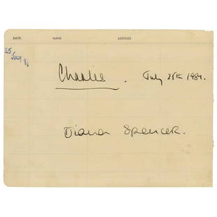
Sold2022Princess Diana and Prince Charles SignaturesFantastic pair of fountain pen signatures, "Charles, July 25th 1984" and "Diana Spencer,” on an off-white 8 x 6 guest book page, signed just four days before the 1981 Royal Wedding. AdditionallySee Sold Price
Sold2022San Francisco Tide Lands for sale at auctionHeading: -1871 Author: Allardt, Geo. F., Surveyor Title: Map No. 6 of Salt Marsh and Tide Lands situated in the City and County of San Francisco, to be sold at public auction by order of the Board ofSee Sold Price
Sold20231881 NANTUCKET MAP BY STONERScarce, original map BIRDSEYE VIEW OF THE TOWN OF NANTUCKET LOOKING SOUTHWEST 1881 by JJ Stoner of Wisconsin. The visual appeal of the image is enhanced by inset views of Siaconset, Sankatty Head LighSee Sold Price
Sold2022Rare First American Revolutionary War Battle MapAmerican Revolution First American Printing Of A Revolutionary War Battle Map "A View of the Present Seat of War, at and near New-York." 1777-Dated (Printed 1776) Revolutionary War Period, Printed MapSee Sold Price
Sold2021George Balthasar Probst (1673 - 1748), engraving, viewGeorge Balthasar Probst (1673 - 1748), engraving, view map of "Paris", No. 39, paper size 17 x 47 inches, frame size 25 x 55 inches.See Sold Price
Sold2023Jamali, Pakistani / American (Born 1944)Jamali, Pakistani / American (Born 1944) "Portrait of a Woman" Palace Size Artist Proof Giclee on Canvas, Signed Lower Left. Document and gallery label attached en verso. Jamali book to accompany theSee Sold Price
BonhamsSALTRAM HOUSE, DEVON - MORLEY FAMILY PHOTOGRAPH ALBUMS Three albums of photographs (mostly carte...£500
BonhamsBOWYER (ROBERT) An Illustrated Record of Important Events in the Annals of Europe, During the La...£800
BonhamsLONDON PARKS LARWOOD (JACOB) The Story of the London Parks, John Camden, [c. 1880]--SMITH (THOMA...£1,600
BonhamsPAPWORTH (JOHN BUONAROTTI) Select Views of London; with Historical and Descriptive Sketches of S...£1,600
Jun 23Schilb Antiquarian Rare Books1855 San Francisco 1st ed California Gold Rush Illustrated MAPS Soule Indians$11(3 bids)
1 day LeftSchilb Antiquarian Rare Books1871 Holy BIBLE & MAPS Holy Land Hitchcock Analysis Gruden Concordance Theology$130(4 bids)
6 days LeftFreeman's | HindmanMURCHISON, Roderick Impey, Sir. The Silurian System. 1839. COMPLETE WITH VERY RARE HAND-COLORED$1,500
24 hrs LeftRapid Estate Liquidators and Auction GallerySigned Faith Popcorn The Popcorn Report Hardcover$25
6 days LeftFreeman's | Hindman[MAPS]. HOMANN, Johann Baptist, HOMANN HEIRS, and Georg Matthäus SEUTTER. [Composite Atlas].$15,000


![MAPS IN BOOKS, Atlases, Buy de Mornas: Contains 135 Double-Page Maps in Contemporary Color. Atlases. Claude Buy de Mornas, [4 Volumes] Atlas Methodique et Elementaire de Geographie et d'Histoire, 1761-62 (published). Hand Color. A large an](https://p1.liveauctioneers.com/6576/320593/172252664_1_x.jpg?height=310&quality=70&version=1708729193)


![LONDON PARKS LARWOOD (JACOB) The Story of the London Parks, John Camden, [c. 1880]--SMITH (THOMA... (1 of 8)](https://p1.liveauctioneers.com/1043/319451/178359231_1_x.jpg?height=282&quality=70&version=1716978902)


![[MAPS]. HOMANN, Johann Baptist, HOMANN HEIRS, and Georg Matthäus SEUTTER. [Composite Atlas]. (1 of 5)](https://p1.liveauctioneers.com/197/329395/177650530_1_x.jpg?height=282&quality=70&version=1715364962)

