Sold2021Vintage World MapVintage world map, framed 18"h x 15.5"w Provenance: The Estate of Nancye Miller, Alamo Heights, TXSee Sold Price
Sold2021Vintage World MapVintage world map, print, framed 21.5"h x 19"w Provenance: The Estate of Nancye Miller, Alamo Heights, TXSee Sold Price
Sold20224 Vintage World Map PrintsPenn Prints New York. Each overall with frame 17-1/4" high x 21-1/4" wide. LR IMPORTANT: Before bidding, please read the terms and conditions. When you registered for the auction you agreed to these tSee Sold Price
Sold2022Vintage World Map Umbrella StandVintage world map tole umbrella stand. [20 1/2" H x 9 1/2" Diam.]. Dents.See Sold Price
Sold2023Collection of Vintage World MapsAssorted antique maps - mostly World, Western Hemisphere, North and South America. Approximately 50 pieces. As is, as shown. Provenance: Phyllis Lucas Gallery, NYC.See Sold Price
Sold2023Collection of Large Vintage World MapsLarge format MAPS and city views. Approximately 50 pieces. As is, as shown. Provenance: Phyllis Lucas Gallery, NYC.See Sold Price
Sold2023Collection of Vintage World MapsAssorted antique MAPS, mainly England, Ireland, Africa, Middle East, and more. Approximately 50 pieces. As is, as shown. Provenance: Phyllis Lucas Gallery, NYC.See Sold Price
Sold2023Collection of Vintage World MapsAssorted antique MAPS, mainly U.S., U.K., France, and more. Approximately 50 pieces. As is, as shown. Provenance: Phyllis Lucas Gallery, NYC.See Sold Price
Sold2021Vintage Atlas School Map CabinetVintage Atlas School map cabinet, to include vintage world maps in wooden display case 19"h x 53.5"w x 4"d Provenance: The Estate of Barbara "Babs" Baugh (San Antonio, Texas) WeSee Sold Price
Sold2021Vintage 1980s World Map Watch Wall ClockA perfect vintage world map wrist watch shaped wall clock from the 1980s. Looks exactly like a wrist watch blown up to fit a giant's wrist! Just under four feet tall, this amazing clock has oversizedSee Sold Price
Sold2023VINTAGE SCHOOLHOUSE WORLD MAP CABINET WITH 18 MAPSLarge wood map case with a sailboat scene on the front door that opens up to hold 18 vintage maps. Each map is on a linen cloth and placed on rollers that display each map. The maps date from the 1930See Sold Price
Sold2018PanAM: Vintage Pictorial World Map, 1957Title/Content of Map: 1957 PanAM Pictorial World Map -- Your Clipper Cargo Market Area Date Printed: 1957 c. Cartographer: PanAm Size: 22 x 34 in. A very interesting world map showing PanAm cargo routSee Sold Price
Sold2018Vintage Piscator World Map silk embroideryVintage Piscator World Map silk embroidery. This is not a print or etching. It is a rare multimedia on silk embroidery including gold leaves after 17th century Commander's Map. In a mahogany frame witSee Sold Price
Sold2024Vintage Full Color World Map LithographVintage full colored world map, reading Typvs Orbis Terrarvm with blue and red colors and scrolled motifs with Greco Roman lion and Figural heads and sections in Latin Frame in a tan toned wooden framSee Sold Price
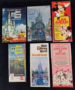
Sold2021Six Vintage Walt Disney World Maps GuidebooksThis lot includes: (1) Walt Disney World 1973 Spring/Summer Information Guide. (1) Walt Disney World Discover Guide. Oct 1, 1981 to Sept 30, 1982. (1) "Save Time At Exit 68"! Information Center Card.See Sold Price
Sold2021Geochron Vintage Wall Hanging World Time Map ClockVintage Geochron World Time Map and Clock. Wall hanging lighted clock. Features a moving world map that shows time around the world along with the date, day and minutes. SHIPPINGHill Auction Gallery wSee Sold Price
Sold2024Nova Totius Full Color Geographical World MapVintage full color world map in Latin, reading Nova Totius Terrarum Orbis Geographica Ac Hy Drographica Tabula. Depicts the world map with Latin sections and margins are filled with Greco Roman figureSee Sold Price
Sold2022Silver Plate World Map by Royal Geographical SocietyVintage Silver plate World Map by Royal Geographical Society etched oto Silver Panel decoated in 24 ct Gold Only 1000 were ever made by Franklin Mint 20th Century Art on Wood Frame Ready to hang 27" xSee Sold Price
Sold201911 Vintage Assorted World War II Maps of Europe11 Vintage Assorted World War II Maps of Europe from the 1940's, used condition, wear, worn.See Sold Price
Sold2021VINTAGE GOLD FOIL 1630 ANTIQUE WORLD MAPVINTAGE GOLD FOIL 1630 ANTIQUE WORLD MAP "Nova Totius Terrarum Orbis Geographica Ac Hydrographica TAbvla" Print, Framed. Size: 23 X 19 inches. Private Collection.See Sold Price
Sold2022Vintage Air France Airline Travel Routes World MapVintage Air France Airline Travel Routes World Map, by Lucien Boucher (French, 1889-1971) color offset, C.1948. Framed. Size: 19.5'' x 33.75'', 50 x 86 cm (sight); 24.5'' x 39'', 62 x 99 cm (frame).See Sold Price
Sold2018Vintage Polar Projection of WWII World Pictorial MapTitle/Content of Map: 1943 Alcoa Aluminum Polar Projection of World at World Pictorial Map -- Global Map for Global War and Global Peace Date Printed: 1943 Cartographer: Alcoa Aluminum Co. Size: 24.4See Sold Price
Sold2016Vintage Hammond's International Map of WorldVintage Hammond's International Map of the World. Prepared for the World Book Encyclopedia. 35" H x 51" W.See Sold Price
Sold2024GROUP OF ANTIQUE AND VINTAGE MAPS, INC.. NORTH AND SOUTH AMERICA, WORLD MAPS, LOSSES THROUGHOUT,GROUP OF ANTIQUE AND VINTAGE MAPS, INC.. NORTH AND SOUTH AMERICA, WORLD MAPS, LOSSES THROUGHOUT, 19.5 X 26 LARGESTSee Sold Price
Jun 20The Ross Art GroupOriginal Vintage Air France World Route Map Vickers Viscount Poster 1956 Constellation$600
3 days LeftActivity AuctionsOriginal WWII Vintage Map Poster COME Z SECTION BOUNDARIES World War USA Rare!$200
Jun 20The Ross Art GroupOriginal Vintage Chocolat Menier Le Tour de Monde Poster by Jannot 1956 Chocolate Map$500
Jun 20The Ross Art GroupOriginal Air France Planisphere Brown Vintage Map by Lucien Boucher 1948$1,200
Featured4 days LeftJasper52THE PORT OF LONDON showing wharves & docks. Thames. Vintage map. BACON 1919$480
3 days LeftJasper521817 3 VOYAGES of CAPTAIN COOK 6 vols ILLUSTRATED w/ WORLD MAP antique in FRENCH$1,000
1 day LeftWorthington Galleries19th c. Hemisphere World Map, Hohen und Tiefen der Erde in Lambert’s Zenithal-Projection von$10
4 days LeftJasper52Port di Napoli. Naples, Italy. ADMIRALTY sea chart 1937 (1955) old vintage map$280


![Vintage World Map Umbrella Stand: Vintage world map tole umbrella stand. [20 1/2" H x 9 1/2" Diam.]. Dents.](https://p1.liveauctioneers.com/1221/239309/124422162_1_x.jpg?height=310&quality=70&version=1646969011)