


19th c. NEW MAP OF SOUTH CAROLINA
Similar Sale History
View More Items in Maps & Atlases


![Emanuel Bowen Map North & South Carolina, Georgia: [Emanuel Bowen Map of North & South Carolina and Georgia] , "A New & Accurate Map of the Provinces of North & South Carolina Georgia & c. Drawn from late Surveys and regulated by Astron Observat. By E](https://p1.liveauctioneers.com/268/293228/155705053_1_x.jpg?height=310&quality=70&version=1687296979)


![1894 Cowles Civil War Map of South Carolina and Parts: Title/Content of Map: 1894 Cowles Civil War Map of South Carolina and Parts of North Carolina -- General Topographical Map, Sheet IV [Plate CXXXIX] Date: 1894, Washington Cartographer: C Cowles (compi](https://p1.liveauctioneers.com/5584/162222/81927562_1_x.jpg?height=310&quality=70&version=1582719732)
Related Maps & Atlases

![1892 Black Map of Australia [on Separate Sheet] New South Wales [on Separate Sheet] Victoria: Title: 1892 Black Map of Australia [on Separate Sheet] New South Wales [on Separate Sheet] Victoria Cartographer: A&C Black Year / Place: 1892, Edinburgh Map Dimension (in.): 16.2 X 21.7 in. Largest T](https://p1.liveauctioneers.com/5584/327462/176400631_1_x.jpg?height=310&quality=70&version=1714507756)


![1761 NEW DICTIONARY OF TRADE & COMMERCE R. ROLT antique FOLIO ILLUSTRATED w/MAPS: A New Dictionary of Trade and Commerce... The Second edition [preface by Samuel Johnson] With the Addition of a New and Accurate Set of Maps... by Mr. Bowen. London: 1761 by Richard ROLT. Folio: 9.5 b](https://p1.liveauctioneers.com/5584/327967/176717236_1_x.jpg?height=310&quality=70&version=1714507672)


More Items in Maps & Atlases
View More


![[Maps] Gio. Ant. Magnini, Italia, 1620: [Maps] Gio. Ant. Magnini, Italia, 1620, Giovanni Antonio Magnini. Italia, data in luce da Fabio suo figliuolo al Serenissimo Ferdinado Gonzaga Duca di Matoua edi Monserrato etc. Bologna, for Sebastian](https://p1.liveauctioneers.com/188/326797/176317457_1_x.jpg?height=310&quality=70&version=1713847031)


Recommended Transportation & Travel Collectibles
View More


Item Details
Description
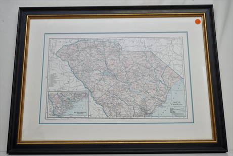
Rare 19th c. A New Map of South Carolina with its Canals, Roads & Distances from place to place along the Stage & Steam Boat Routes. By H.S. Tanner c. 1841-1845. Fine example of Tanner's map of South Carolina, with large inset map of Charleston, from the last edition of Tanner's Universal Atlas. The map is hand colored by counties, and shows towns, roads with distances, steam and stage routes, railroads, canals, and a host of other details.The Charleston key includes about 45 place names, streets and substantial detail. Professionally framed and matted. In frame Measures 16"x19"x1". Weight 3 pds. PROVENANCE: A Private Charleston SC Estate
Condition
good
Buyer's Premium
- 18% up to $50,000.00
- 15% up to $1,000,000.00
- 10% above $1,000,000.00
19th c. NEW MAP OF SOUTH CAROLINA
Estimate $350 - $450
11 bidders are watching this item.
Shipping & Pickup Options
Item located in Mt. Pleasant, SC, usOffers In-House Shipping
Local Pickup Available
Payment
Accepts seamless payments through LiveAuctioneers

TOP