


Bellin/Prevost: Sierra Leone & Liberia Coastal Charts
Similar Sale History
View More Items in Maps & Atlases


![Ireland.- [Bellin (Jacques Nicolas)] Carte Réduite: Ireland.- [Bellin (Jacques Nicolas)] Carte Réduite des Isles Britanniques Cinquieme Feuille Contenant L'Irlande, large map and coastal chart of Ireland, engraving with hand-colouring, two sheets](https://p1.liveauctioneers.com/5458/236692/122702351_1_x.jpg?height=310&quality=70&version=1644332470)


Related Maps & Atlases


![Western Africa by Edward Weller. Early British/French settlements 1860 old map: Title: Western Africa by Edward Weller. Early British/French settlements 1860 old map Description: Western Africa [including Senegambia, Sierra Leone, Bambarra, Ashantee, Dahomey, Sokoto, Bornou, &c,]](https://p1.liveauctioneers.com/5584/330582/178266404_1_x.jpg?height=310&quality=70&version=1716924723)
![Western Africa by Edward Weller. Early British/French settlements 1859 old map: Title: Western Africa by Edward Weller. Early British/French settlements 1859 old map Description: Western Africa [including Senegambia, Sierra Leone, Bambarra, Ashantee, Dahomey, Sokoto, Bornou, &c,]](https://p1.liveauctioneers.com/5584/330582/178266346_1_x.jpg?height=310&quality=70&version=1716924723)


More Items in Maps & Atlases
View More
![[MAP]. TODESCHI, Pietro. [Nova et Acurata Totius Americae Tabula auct. G.I. Blaeu] America quarta: [MAP]. TODESCHI, Pietro. [Nova et Acurata Totius Americae Tabula auct. G.I. Blaeu] America quarta pars orbis quam plerunq, nuvum orbem appellitant primo detecta est anno 1492 a Christophoro Columbo...](https://p1.liveauctioneers.com/197/329395/177650542_1_x.jpg?height=310&quality=70&version=1715364962)

![[MAPS]. HOMANN, Johann Baptist, HOMANN HEIRS, and Georg Matthäus SEUTTER. [Composite Atlas].: [MAPS]. HOMANN, Johann Baptist (1663-1724), HOMANN HEIRS, and Georg Matthäus SEUTTER (1678-1757). [Composite Atlas]. [Nuremberg, Augsburg, and others: Homann Heirs and others, maps dated between](https://p1.liveauctioneers.com/197/329395/177650530_1_x.jpg?height=310&quality=70&version=1715364962)


![[MAP]. ORTELIUS, Abraham. Americae Sive Novi Orbis, Nova Descriptio. 1573.: [MAP]. ORTELIUS, Abraham (1527-1598). Americae Sive Novi Orbis, Nova Descriptio. Antwerp, 1573. Engraved map with hand-coloring. Framed and double glazed, visible area 375 x 521 mm (unexamined out of](https://p1.liveauctioneers.com/197/329395/177650534_1_x.jpg?height=310&quality=70&version=1715364962)
![Set of Twelve Satirical Anthropomorphic Maps of Europe: [SATIRICAL MAPS] A set of twelve satirical anthropomorphic maps of Europe. London: circa 1868. A set of 12 (believed complete) lithographed maps by Vincent Brooks, Day & Son, London, each offering](https://p1.liveauctioneers.com/292/330597/178279264_1_x.jpg?height=310&quality=70&version=1716409282)


![[MAP]. ORTELIUS, Abraham. Turcici Imperii Descriptio.1592.: [MAP]. ORTELIUS, Abraham (1527-1598). Turcici Imperii Descriptio. Antwerp, 1592. Engraved map with hand-coloring. Matted, framed, and double glazed, sight 406 x 521 mm (unexamined out of frame). Decor](https://p1.liveauctioneers.com/197/329395/177650538_1_x.jpg?height=310&quality=70&version=1715364962)
![[MAP]. ORTELIUS, Abraham. Romani Imperii Imago. 1592.: [MAP]. ORTELIUS, Abraham (1527-1598). Romani Imperii Imago. Antwerp, 1592. Engraved map with hand-coloring. Matted, framed, and double glazed, visible area 381 x 521 mm (unexamined out of frame). 6 de](https://p1.liveauctioneers.com/197/329395/177650537_1_x.jpg?height=310&quality=70&version=1715364962)
![[MAP]. SPEED, John. A New Mappe of the Romane Empire. 1676.: [MAP]. SPEED, John (ca 1551-1629). A New Mappe of the Romane Empire. London: Basset & Chiswell, 1676. Engraved map with hand-coloring. Framed and double glazed, sight 419 x 559 mm. Decorative cartouch](https://p1.liveauctioneers.com/197/329395/177650541_1_x.jpg?height=310&quality=70&version=1715364962)
Recommended Transportation & Travel Collectibles
View More

![[FLAGS]. 31-star American parade flag. Ca 1850-1859.: [FLAGS]. 31-star American parade flag. Ca 1850-1859. 22 x 36 1/2 in. cotton flag with 31 printed stars, configured in a double medallion surrounding a much larger central star, that is haloed in both](https://p1.liveauctioneers.com/197/329785/177758218_1_x.jpg?height=310&quality=70&version=1715625218)


![[FLAGS]. 13-star American flag, possibly a US Navy boat flag. Ca late-19th century.: [FLAGS]. 13-star American flag, possibly a US Navy boat flag. Ca late-19th century. 35 x 71 1/2 in. hand-sewn and machine-sewn wool flag with 13 double-appliquéd cotton stars configured in 3/2/3/2/3](https://p1.liveauctioneers.com/197/329785/177758215_1_x.jpg?height=310&quality=70&version=1715625218)


Item Details
Description
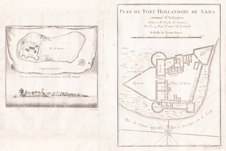
Two highly detailed Bellin charts of the Sierra Leone and Liberia ("Guinea") coasts on the same composite page from the atlas volume of Prévost d'Exiles' collection of travel narratives, Histoire Générale des Voyages. The chart on the left is of the coast of Sierra Leone encompassing the mouths of the Sierra Leone and Sherbro Rivers and Sherbro Island. In the upper right corner is an inset chart of the Sierra Leone River estuary, the African continent's largest natural harbor. The chart on the right is of the coast of present-day Liberia from Cape Mount to the Cestos River and the Grain ("Malagette") Coast. Indigenous tribal territories are indicated in the otherwise blank interior. In the upper right corner is a detailed inset chart of the mouth of the Cestos River with an illustration of a river canoe and paddle.
Reserve: $25.00
Shipping:
Your purchase is protected:
Photos, descriptions, and estimates were prepared with the utmost care by a fully certified expert and appraiser. All items in this sale are guaranteed authentic.
In the rare event that the item did not conform to the lot description in the sale, Jasper52 specialists are here to help. Buyers may return the item for a full refund provided you notify Jasper52 within 5 days of receiving the item.
Condition
B&w; light overall age toning; map #2 is a light impression
Buyer's Premium
- 15%
Bellin/Prevost: Sierra Leone & Liberia Coastal Charts
Estimate $30 - $40
Get approved to bid.
Shipping & Pickup Options
Item located in New York, US$14 shipping in the US
Payment
Accepts seamless payments through LiveAuctioneers
See More Items From This Jasper52 Seller

Related Searches
TOP