


1818 French Map of Europe by Charles Simonneau
Similar Sale History
View More Items in Art


Related Art


More Items in Art
View More


Item Details
Description
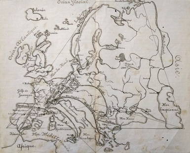
This 1818 French map of Europe is done by graveur Charles Simonneau of Paris. It is colored by country and has city close ups of London, Vienna, Paris, Petersburg, Constantinople, Rome, Naples, Madrid, Berlin, Copenhagen, Stockholm, and Warsaw. Total size is approx. 30" high x 43.5" wide when unfolded. It also has an angel in the sky blowing a trumpet engraving over ocean. It is sectioned in pieces on a heavy linen backing that has a French label in corner titled Europe and a small area with hand written letters which were crossed out partially.
Buyer's Premium
- 25%
1818 French Map of Europe by Charles Simonneau
Estimate $250 - $750
9 bidders are watching this item.
Shipping & Pickup Options
Item located in York, PA, usSee Policy for Shipping
Local Pickup Available
Payment
Accepts seamless payments through LiveAuctioneers

Related Searches
TOP