


WORLD MAP & MONTREAL MAP
Gibson Sale History
View Price Results for Gibson


![World.- Bordone (Benedetto di) [World Map], woodcut, [1522].: World.- Bordone (Benedetto di) [World Map], early map showing the recent developments in cartography and departing from Ptolemaic models, including open water between the two continents and not joinin](https://p1.liveauctioneers.com/5458/252576/131355887_1_x.jpg?height=310&quality=70&version=1655911671)


![1703 Scherer - World Map [California as an Island]: Title: World Map [without title] "Map maker: Heinrich Scherer, Atlas Marianus" "Place and Year: Munich, 1703" "Dimensions: 23.6 x 35.5 cm (9.3 x 14 in)" "Technique: Copperplate engraving" "Coloring: U](https://p1.liveauctioneers.com/5584/112867/57947644_1_x.jpg?height=310&quality=70&version=1511920104)
Related Maps & Atlases


More Items from Gibson
View More


![[Gettysburg] The Horrors of War: The Horrors of War. Albumen photograph. Printed title to mount recto with caption. An image taken by photographer James F. Gibson (d. 1905) in the immediate aftermath of the Battle of Gettysburg. Prin](https://p1.liveauctioneers.com/7226/325455/175169090_1_x.jpg?height=310&quality=70&version=1712370394)


Recommended Transportation & Travel Collectibles
View More


Item Details
Description
Gibson, John. A PARTICULAR MAP, TO ILLUSTRATE GEN. AMBERST'S EXPEDTIION, TO MONTREAL; WITH A PLAN OF THE TOW & DRAUGHT OF YE ISLAND (London: The Gentleman's Magazine, ca. 1760).
Copper engraving. Hand colored. Map of St. Lawrence River Valley and its constituent cities and regions. Includes Montreal city plans and map of Island of Montreal.
Dimensions of frame: H. 12.25" W. 13.75"
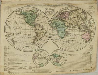
McIntyre, Archibald. THE WORLD FROM THE BEST AUTHORITIES (Edinburgh: Alexander Kincaid, 1791). Copper engraving. Hand colored. Shows 6 continents with Australia as "New Holland," political boundaries, a few major cities, and Zodiac, "ecliptick," and "equinoctial" lines.
Dimensions: H. 16" W. 23"
Copper engraving. Hand colored. Map of St. Lawrence River Valley and its constituent cities and regions. Includes Montreal city plans and map of Island of Montreal.
Dimensions of frame: H. 12.25" W. 13.75"
McIntyre, Archibald. THE WORLD FROM THE BEST AUTHORITIES (Edinburgh: Alexander Kincaid, 1791). Copper engraving. Hand colored. Shows 6 continents with Australia as "New Holland," political boundaries, a few major cities, and Zodiac, "ecliptick," and "equinoctial" lines.
Dimensions: H. 16" W. 23"
Condition
Condition report available upon request.
Buyer's Premium
- 25%
WORLD MAP & MONTREAL MAP
Estimate CA$200 - CA$300
7 bidders are watching this item.
Shipping & Pickup Options
Item located in Toronto, ON, caSee Policy for Shipping
Payment

Related Searches
TOP