


Gall & Inglis (publishers) The Edinburgh Imperial Atlas
Similar Sale History
![Summer Gleanings of a Pastor's Vacation, 1852: Heading: Author: Todd, John Title: Sketches and Incidents: or, Summer Gleanings of a Pastor's Vacation Place Published: Edinburgh Publisher:Gall & Inglis Date Published: [1852] Descrip](https://p1.liveauctioneers.com/642/93238/47584067_1_x.jpg?height=310&quality=70&version=1472923400)


![19th C Decorative Bindings: Two Decorative Bindings. Nicely Embossed Spines: “The Poetical Works of Thomas Campbell and Samuel Taylor Coleridge with Lives”, Edinburgh, Gall and Inglis, [c1856]; and :Les Confessions de J.J. R](https://p1.liveauctioneers.com/3798/82117/42559755_1_x.jpg?height=310&quality=70&version=1447690426)


Recommended Items


Item Details
Description
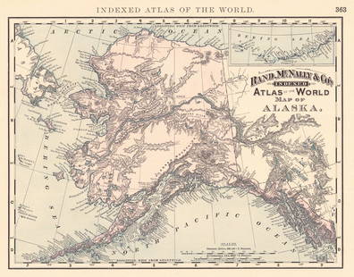
Gall & Inglis (publishers) The Edinburgh Imperial Atlas Ancient and Modern, revised and corrected to the Present Time, from the Best Authorities. Edinburgh: Gall & Inglis, c.1860. Folio (52.5 x 33.8cm), contemporary half morocco, wood-engraved title-page, letterpress title-page, 47 wood-engraved or lithographic maps, all hand-coloured, nearly all double-page, variable light offsetting from colouring, small tear in 'Asiatic Islands and New Holland', 19th-century ownership inscriptions to initial blank
Note: The maps include Arabia, Persia, 'Hindostan', China and Japan, Canada and British North America, Islands of the Pacific Ocean, United States, and Australian Colonies and New Zealand.
Note: The maps include Arabia, Persia, 'Hindostan', China and Japan, Canada and British North America, Islands of the Pacific Ocean, United States, and Australian Colonies and New Zealand.
Buyer's Premium
- 30% up to £500,000.00
- 25% above £500,000.00
Gall & Inglis (publishers) The Edinburgh Imperial Atlas
Estimate £300 - £400
Shipping & Pickup Options
Item located in Edinburgh, Scotland, ukSee Policy for Shipping
Local Pickup Available
Payment

TOP