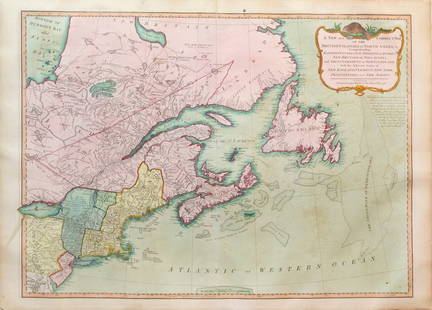
New and Correct Map of North America With the West India Islands,
Similar Sale History
View More Items in Maps & AtlasesRelated Maps & Atlases
More Items in Maps & Atlases
View MoreRecommended Transportation & Travel Collectibles
View More


Item Details
Description
"divided according to the last treaty of peace at Paris 10th Feb. 1763... corrected from the Original Materials of Govern. Pownall, Member of Parliament." (lower portion only) Docket notations and cork stamp of the Cartographic Depot of the Ministry of Marine, French Empire. Covers the area from lower Baja through Texas (area "Little Known", entire Gulf Coast, mouth of the Mississipi or St. Louis (River)", much Florida detail including "Spanish Fort built 1719", Fort Diego (& British St. George's fort above), St. Augustine, "Southerrn Bounds by charter 1665", southern third of peninsula broken up into islands, C. Biscayne. Detail of all Bahamas, Great Antilles and Caribbean Islands. Includes a 8 x 8" inset "The passage by land to California" by Fr. Kino. that shows Baja and Sea of California with excellent detail of southern Arizona (Pimeria) Sonora Mexico to Cinaolia (sic). Three settlements/missions above St. Francis Xavier du Bac are shown: St. Cosime and St. Augustin near modern Tucson. A large rococo cartouche shows 7 mileage scales, trading paths, portages, falls and salt pits. A long textual notation in the Atlantic concerns the recent 1763 Treaty of Paris. Important historic map showing British ascending after the French & Indian War. Somewhat browned left hand side. West India Islands, Florida, Texas & Central America
Reserve: $1,250.00
Shipping:
Your purchase is protected:
Photos, descriptions, and estimates were prepared with the utmost care by a fully certified expert and appraiser. All items in this sale are guaranteed authentic.
In the rare event that the item did not conform to the lot description in the sale, Jasper52 specialists are here to help. Buyers may return the item for a full refund provided you notify Jasper52 within 5 days of receiving the item.
Condition
Good
Buyer's Premium
- 15%
New and Correct Map of North America With the West India Islands,
Estimate $2,000 - $2,500
1 bidder is watching this item.
Get approved to bid.
Shipping & Pickup Options
Item located in Tennessee, US$24 shipping in the US
Payment
Accepts seamless payments through LiveAuctioneers
See More Items From This Jasper52 Seller

Auction Curated By

Maps Expert
Related Searches
TOP


![[MAP-CARIBBEAN] History of the West India Islands [caption title] and folding map extracted from an: [MAP-CARIBBEAN] History of the West India Islands [caption title] and folding map extracted from an 18th century work. The text volume in modern cloth, caption titled History of the West India Islands](https://p1.liveauctioneers.com/292/250642/130213651_1_x.jpg?height=310&quality=70&version=1654271664)
![[Maps & Atlases] A New Map of North America, with the West India Islands...: [Maps & Atlases] A New Map of North America, with the West India Islands... A New Map of North America, with the West India Islands. Divided according to the Preliminary Articles of Peace, Signed at V](https://p1.liveauctioneers.com/65/332523/179335173_1_x.jpg?height=310&quality=70&version=1717709447)
![Jacob Monk 1853 Map of North America [173506]: Large wall map, typical nvarnish finish, mounted to board for viewing. "New map of that portion of North America exhibiting the United States and Territories, the Canadas, New Brunswick, Nova Scotia,](https://p1.liveauctioneers.com/2699/331495/178785775_1_x.jpg?height=310&quality=70&version=1717094933)


![North America Map circa 1800s [179302]: Early map of the North American continent circa 1810. Shows the western area as New Albion, southwest Canada as New Caledonia and the Russian Possessions of western Canada and Alaska. Also noted are s](https://p1.liveauctioneers.com/2699/331495/178785793_1_x.jpg?height=310&quality=70&version=1717094933)


![French Map of America Southeast [179304]: Northeastern American map published 1788 from a French cartographer. Map measures 9"x 13". Published during America's War of Independence from Great Britain (1176-1783), this map features the mid-Atla](https://p1.liveauctioneers.com/2699/331495/178785746_1_x.jpg?height=310&quality=70&version=1717094933)


![Descrittione… Santa Croce Mondo Nuovo PORCACCHI North America New World 1590 map: CAPTION PRINTED BELOW PICTURE: Descrittione dell' Isola et Terra di Santa Croce, overo Mondo Nuovo [Description of North America or the New World] DATE PRINTED: 1590 IMAGE SIZE: Approx 20.5 x 29.5cm,](https://p1.liveauctioneers.com/5584/332390/179262957_1_x.jpg?height=310&quality=70&version=1717528223)
![[MAPS]. HOMANN, Johann Baptist, HOMANN HEIRS, and Georg Matthäus SEUTTER. [Composite Atlas].: [MAPS]. HOMANN, Johann Baptist (1663-1724), HOMANN HEIRS, and Georg Matthäus SEUTTER (1678-1757). [Composite Atlas]. [Nuremberg, Augsburg, and others: Homann Heirs and others, maps dated between](https://p1.liveauctioneers.com/197/329395/177650530_1_x.jpg?height=310&quality=70&version=1715364962)
![[MAP]. TODESCHI, Pietro. [Nova et Acurata Totius Americae Tabula auct. G.I. Blaeu] America quarta: [MAP]. TODESCHI, Pietro. [Nova et Acurata Totius Americae Tabula auct. G.I. Blaeu] America quarta pars orbis quam plerunq, nuvum orbem appellitant primo detecta est anno 1492 a Christophoro Columbo...](https://p1.liveauctioneers.com/197/329395/177650542_1_x.jpg?height=310&quality=70&version=1715364962)
![[MAP]. ORTELIUS, Abraham. Americae Sive Novi Orbis, Nova Descriptio. 1573.: [MAP]. ORTELIUS, Abraham (1527-1598). Americae Sive Novi Orbis, Nova Descriptio. Antwerp, 1573. Engraved map with hand-coloring. Framed and double glazed, visible area 375 x 521 mm (unexamined out of](https://p1.liveauctioneers.com/197/329395/177650534_1_x.jpg?height=310&quality=70&version=1715364962)


![[MAP]. ORTELIUS, Abraham. Turcici Imperii Descriptio.1592.: [MAP]. ORTELIUS, Abraham (1527-1598). Turcici Imperii Descriptio. Antwerp, 1592. Engraved map with hand-coloring. Matted, framed, and double glazed, sight 406 x 521 mm (unexamined out of frame). Decor](https://p1.liveauctioneers.com/197/329395/177650538_1_x.jpg?height=310&quality=70&version=1715364962)
![[MAP]. SPEED, John. A New Mappe of the Romane Empire. 1676.: [MAP]. SPEED, John (ca 1551-1629). A New Mappe of the Romane Empire. London: Basset & Chiswell, 1676. Engraved map with hand-coloring. Framed and double glazed, sight 419 x 559 mm. Decorative cartouch](https://p1.liveauctioneers.com/197/329395/177650541_1_x.jpg?height=310&quality=70&version=1715364962)
![Set of Twelve Satirical Anthropomorphic Maps of Europe: [SATIRICAL MAPS] A set of twelve satirical anthropomorphic maps of Europe. London: circa 1868. A set of 12 (believed complete) lithographed maps by Vincent Brooks, Day & Son, London, each offering](https://p1.liveauctioneers.com/292/330597/178279264_1_x.jpg?height=310&quality=70&version=1716409282)


![Sanitary & Topographical "Viele Map" of Manhattan 1865 [182838]: Manhattan Island map surveyed by Mexican American & Civil War veteran Egbert Viele 1865. Viele was author of a color city map, a "Sanitary & Topographical Map of the City and Island of New York," firs](https://p1.liveauctioneers.com/2699/331495/178785766_1_x.jpg?height=310&quality=70&version=1717094933)
![[MAP]. ORTELIUS, Abraham. Romani Imperii Imago. 1592.: [MAP]. ORTELIUS, Abraham (1527-1598). Romani Imperii Imago. Antwerp, 1592. Engraved map with hand-coloring. Matted, framed, and double glazed, visible area 381 x 521 mm (unexamined out of frame). 6 de](https://p1.liveauctioneers.com/197/329395/177650537_1_x.jpg?height=310&quality=70&version=1715364962)


