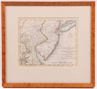
A map of Philadelphia and parts adjacent. Pennsylvania. SCULL & HEAP 1777
Similar Sale History
View More Items in Maps & AtlasesRelated Maps & Atlases
More Items in Maps & Atlases
View MoreRecommended Transportation & Travel Collectibles
View More


Item Details
Description
TITLE/CONTENT OF MAP: 'A map of Philadelphia and parts adjacent by N. Scull and G. Heap'
The map was printed to illustrate the Philadelphia campaign (1777–1778) of the American Revolutionary War, a British initiative to gain control of Philadelphia, at that time the seat of the Second Continental Congress. British General William Howe, after unsuccessfully attempting to draw the Continental Army under General George Washington into a battle in northern New Jersey, embarked his army on transports, and landed them at the northern end of Chesapeake Bay. From there, he advanced northward toward Philadelphia. Washington prepared defenses against Howe's movements at Brandywine Creek, but was flanked and beaten back in the Battle of Brandywine on September 11, 1777, resulting in Howe's occupation of Philadelphia. Washington then unsuccessfully counter-attacked one of Howe's garrisons at Germantown before retreating to Valley Forge for the winter.
DATE PRINTED: 1777
IMAGE SIZE: Approx 35.0 x 30.5cm, 13.75 x 12 inches (Large); Please note that this is a folding map.
TYPE: Antique copperplate map
CONDITION: Fair-to-Good: The map has been printed without a left hand border, as usual. Partial loss of right hand margin, restored. The lower left hand margin has also been restored. Spot. Please note any other blemishes on the scan prior to purchasing this picture. Please contact us if you would like to arrange to view this map. Virtually all antiquarian maps and prints are subject to some normal aging due to use and time which is not obtrusive unless otherwise stated. We offer a no questions asked return policy.
AUTHENTICITY: This is an authentic historic map, published at the date stated above. It is not a modern copy.
VERSO: There is nothing printed on the reverse side, which is plain
FOLDING: This is a folding map.
ARTIST/CARTOGRAPHER/ENGRAVER: N Scull & G Heap
PROVENANCE: "Gentleman's Magazine and Historical Chronicle", by Sylvanus Urban, Gent. London: Printed at St. John's Gate for D. Henry; and sold by F. Newbery, the corner of St Paul's Churchyard, Ludgate Street
Reserve: $650.00
Shipping:Domestic: Flat-rate of $30.00 to anywhere within the contiguous U.S. International: Foreign shipping rates are determined by destination. International shipping may be subject to VAT. Combined shipping: Please ask about combined shipping for multiple lots before bidding. Location: This item ships from the United Kingdom
Your purchase is protected:
Photos, descriptions, and estimates were prepared with the utmost care by a fully certified expert and appraiser. All items in this sale are guaranteed authentic.
In the rare event that the item did not conform to the lot description in the sale, Jasper52 specialists are here to help. Buyers may return the item for a full refund provided you notify Jasper52 within 5 days of receiving the item.
The map was printed to illustrate the Philadelphia campaign (1777–1778) of the American Revolutionary War, a British initiative to gain control of Philadelphia, at that time the seat of the Second Continental Congress. British General William Howe, after unsuccessfully attempting to draw the Continental Army under General George Washington into a battle in northern New Jersey, embarked his army on transports, and landed them at the northern end of Chesapeake Bay. From there, he advanced northward toward Philadelphia. Washington prepared defenses against Howe's movements at Brandywine Creek, but was flanked and beaten back in the Battle of Brandywine on September 11, 1777, resulting in Howe's occupation of Philadelphia. Washington then unsuccessfully counter-attacked one of Howe's garrisons at Germantown before retreating to Valley Forge for the winter.
DATE PRINTED: 1777
IMAGE SIZE: Approx 35.0 x 30.5cm, 13.75 x 12 inches (Large); Please note that this is a folding map.
TYPE: Antique copperplate map
CONDITION: Fair-to-Good: The map has been printed without a left hand border, as usual. Partial loss of right hand margin, restored. The lower left hand margin has also been restored. Spot. Please note any other blemishes on the scan prior to purchasing this picture. Please contact us if you would like to arrange to view this map. Virtually all antiquarian maps and prints are subject to some normal aging due to use and time which is not obtrusive unless otherwise stated. We offer a no questions asked return policy.
AUTHENTICITY: This is an authentic historic map, published at the date stated above. It is not a modern copy.
VERSO: There is nothing printed on the reverse side, which is plain
FOLDING: This is a folding map.
ARTIST/CARTOGRAPHER/ENGRAVER: N Scull & G Heap
PROVENANCE: "Gentleman's Magazine and Historical Chronicle", by Sylvanus Urban, Gent. London: Printed at St. John's Gate for D. Henry; and sold by F. Newbery, the corner of St Paul's Churchyard, Ludgate Street
Reserve: $650.00
Shipping:
Your purchase is protected:
Photos, descriptions, and estimates were prepared with the utmost care by a fully certified expert and appraiser. All items in this sale are guaranteed authentic.
In the rare event that the item did not conform to the lot description in the sale, Jasper52 specialists are here to help. Buyers may return the item for a full refund provided you notify Jasper52 within 5 days of receiving the item.
Buyer's Premium
- 15%
A map of Philadelphia and parts adjacent. Pennsylvania. SCULL & HEAP 1777
Estimate $800 - $1,000
2 bidders are watching this item.
Shipping & Pickup Options
Item located in United Kingdom$30 shipping in the US
Payment
Accepts seamless payments through LiveAuctioneers
See More Items From This Jasper52 Seller

Related Searches
TOP


![2 Maps incl: Scull and Heap. A MAP OF PHILADELPHIA: [United States] 2 Maps. ++ N. Scull and G. Heap. A MAP OF PHILADELPHIA And Parts Adjacent. From the folding map’s 2nd appearance in Gentleman’s Magazine [Lon: Dec. 1777], without the table of dist](https://p1.liveauctioneers.com/179/85723/44108001_1_x.jpg?height=310&quality=70&version=1457209333)


![[Maps] Gio. Ant. Magnini, Italia, 1620: [Maps] Gio. Ant. Magnini, Italia, 1620, Giovanni Antonio Magnini. Italia, data in luce da Fabio suo figliuolo al Serenissimo Ferdinado Gonzaga Duca di Matoua edi Monserrato etc. Bologna, for Sebastian](https://p1.liveauctioneers.com/188/326797/176317457_1_x.jpg?height=310&quality=70&version=1713847031)

![[Maps] Martin Zeiler, Itinerarium Italiae, 1640: [Maps] Martin Zeiler, Itinerarium Italiae, 1640, Martini Zeilleri. Itinerarium Italiae Nov-Antiquae: oder, Raiss-Beschreibung durch Italien, Matthaus Merian, Frankfurt, 40 plates, most double-page, in](https://p1.liveauctioneers.com/188/326797/176317459_1_x.jpg?height=310&quality=70&version=1713847031)


![[MAP]. TODESCHI, Pietro. [Nova et Acurata Totius Americae Tabula auct. G.I. Blaeu] America quarta: [MAP]. TODESCHI, Pietro. [Nova et Acurata Totius Americae Tabula auct. G.I. Blaeu] America quarta pars orbis quam plerunq, nuvum orbem appellitant primo detecta est anno 1492 a Christophoro Columbo...](https://p1.liveauctioneers.com/197/329395/177650542_1_x.jpg?height=310&quality=70&version=1715364962)


