


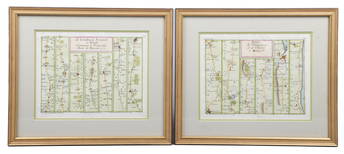
(2) 18th c. road maps, London-Norwich, etc.
Similar Sale History
View More Items in Gas Station Road Maps


Related Gas Station Road Maps


More Items in Gas Station Road Maps
View More
Recommended Transportation & Travel Collectibles
View More


![[Maps] Gio. Ant. Magnini, Italia, 1620: [Maps] Gio. Ant. Magnini, Italia, 1620, Giovanni Antonio Magnini. Italia, data in luce da Fabio suo figliuolo al Serenissimo Ferdinado Gonzaga Duca di Matoua edi Monserrato etc. Bologna, for Sebastian](https://p1.liveauctioneers.com/188/326797/176317457_1_x.jpg?height=310&quality=70&version=1713847031)


![[Maps] Martin Zeiler, Itinerarium Italiae, 1640: [Maps] Martin Zeiler, Itinerarium Italiae, 1640, Martini Zeilleri. Itinerarium Italiae Nov-Antiquae: oder, Raiss-Beschreibung durch Italien, Matthaus Merian, Frankfurt, 40 plates, most double-page, in](https://p1.liveauctioneers.com/188/326797/176317459_1_x.jpg?height=310&quality=70&version=1713847031)


Item Details
Description
Two hand colored maps of roads from London to Norwich, England, and from Shrewsbury to Holywell, England. A printed description in an attached envelope on the back of one states that they were made by one John Senex between c. 1690 and c. 1740, derived from Ogilby's 1675 mapping of England and Wales. Not examined out of frame.
Condition
Absence of a condition report does not deem material without flaw. Please request a current condition report from the office at 610-558-1800 or info@williambunchauctions.com
Buyer's Premium
- 23%
(2) 18th c. road maps, London-Norwich, etc.
Estimate $100 - $200
5 bidders are watching this item.
Shipping & Pickup Options
Item located in Chadds Ford, PA, usSee Policy for Shipping
Local Pickup Available
Payment

Related Searches
TOP