


MAP, Connecticut, Reid
Similar Sale History
View More Items in Maps & Atlases


Related Maps & Atlases


More Items in Maps & Atlases
View More

![[Maps] Martin Zeiler, Itinerarium Italiae, 1640: [Maps] Martin Zeiler, Itinerarium Italiae, 1640, Martini Zeilleri. Itinerarium Italiae Nov-Antiquae: oder, Raiss-Beschreibung durch Italien, Matthaus Merian, Frankfurt, 40 plates, most double-page, in](https://p1.liveauctioneers.com/188/326797/176317459_1_x.jpg?height=310&quality=70&version=1713847031)


![[Maps] Gio. Ant. Magnini, Italia, 1620: [Maps] Gio. Ant. Magnini, Italia, 1620, Giovanni Antonio Magnini. Italia, data in luce da Fabio suo figliuolo al Serenissimo Ferdinado Gonzaga Duca di Matoua edi Monserrato etc. Bologna, for Sebastian](https://p1.liveauctioneers.com/188/326797/176317457_1_x.jpg?height=310&quality=70&version=1713847031)


Recommended Transportation & Travel Collectibles
View More


Item Details
Description
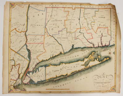
Connecticut. John Reid, Connecticut from the Best Authorities, from Winterbotham's History of America, 1796 (circa). Black & White. This early and uncommon map of Connecticut was engraved by Benjamin Tanner and included in both Winterbothom's History of America and the American Atlas, both published in 1796. Based on Amos Doolittle's map of the previous year, it shows the Oblong, an area of dispute between Connecticut and New York. The boundary line is shown following the Byram River from Long Island Sound to a point in line with the 3 Trees that were used as an early boundary marker. The map is finely detailed showing counties, topography, towns, churches, courthouses, and roads.
Condition
A crisp impression on a bright sheet with light soiling, a small hole above the title cartouche, very light toning along the centerfold, and a couple of short marginal tears that have been closed on verso with archival tape. Grade: B+
Dimensions
14.1 x 17.2 in
Buyer's Premium
- 20% up to $5,000.00
- 15% above $5,000.00
MAP, Connecticut, Reid
Estimate $475 - $600
2 bidders are watching this item.
Shipping & Pickup Options
Item located in Richmond, VA, usOffers In-House Shipping
Local Pickup Available
Payment
Accepts seamless payments through LiveAuctioneers

TOP