


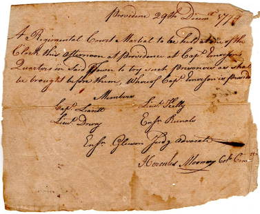
Antique Map of Connecticut and Rhode Island
Similar Sale History
View More Items in Historical Memorabilia

![RHODE ISLAND NEWSPAPER REPORTS ON THE BOSTON MASSACRE: RHODE ISLAND NEWSPAPER REPORTS ON THE BOSTON MASSACRE AND CRISPUS ATTUCKS THE BLACK PATRIOT KILLED IN BOSTON BY BRITISH SOLDIERS Fine colonial-era newspaper, "Supplement to the Newport [Rhode Island]](https://p1.liveauctioneers.com/287/101665/51927988_1_x.jpg?height=310&quality=70&version=1490121316)

![[Declaration of Independence] [Rhode Island] Hopkins, Stephen Cut Signature: [Declaration of Independence] [Rhode Island] Hopkins, Stephen Cut Signature No place, no date (ca. 1755-68). 1 1/4 x 3 in. (31 x 76 mm). Signature of Signer of the Declaration of Independence from Rho](https://p1.liveauctioneers.com/65/295053/156641072_1_x.jpg?height=310&quality=70&version=1688656787)
![An Appeal To The People Of Rhode Island 1857: An Appeal To the People Of Rhode Island, In Behalf Of The Constitution And The Laws; By Thomas, R. Hazard. 1857, this is a presentation copy from the author to Ch. B. Fearing [Charles B. Fearing], sig](https://p1.liveauctioneers.com/2653/296676/157686865_1_x.jpg?height=310&quality=70&version=1689986541)


Related Historical Memorabilia


More Items in Historical Memorabilia
View More


![Document Signed by Two Judges Later Connected to Salem Witch Trials: [SALEM WITCH TRIALS]. HATHORNE, JOHN. (1641-1717). Massachusetts Bay Colony magistrate remembered for his role in the Salem Witch Trials and great-great-grandfather of Nathaniel Hawthorne. ADS. (̶](https://p1.liveauctioneers.com/9124/328425/177345351_1_x.jpg?height=310&quality=70&version=1715202740)
Recommended Collectibles
View More


Item Details
Description
Engraved print map of Connecticut and Rhode Island. Highly detailed revolutionary war era map with towns, roads, rivers, islands, bays and more.
Issued: 1776
Dimensions: 10"W x 8"H
Issued: 1776
Dimensions: 10"W x 8"H
Condition
Age related wear.
Buyer's Premium
- 25%
Antique Map of Connecticut and Rhode Island
Estimate $10 - $200
7 bidders are watching this item.
Shipping & Pickup Options
Item located in Hollywood, FL, usOffers In-House Shipping
Local Pickup Available
Payment
Accepts seamless payments through LiveAuctioneers

Related Searches
TOP