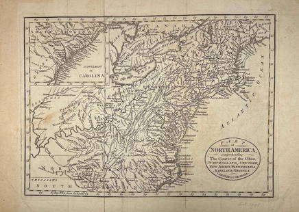
LATE. 18TH C. PARTIAL MAP OF THE ATLANTIC COAST
Similar Sale History
View More Items in Maps & AtlasesRelated Maps & Atlases
More Items in Maps & Atlases
View MoreRecommended Transportation & Travel Collectibles
View More


Item Details
Description
Antonio Zatta (Italian 1757-1797), "Parte Orientale della Florida, della Georgia, e Carolina Meridionale" late 18th century, etching on paper depicting the Atlantic coast during the American Civil War, produced for an atlas, framed.
Approximate dimensions: image h. 12.375", w. 16.625"; frame h. 18", w. 23", d. 1.25".
Approximate dimensions: image h. 12.375", w. 16.625"; frame h. 18", w. 23", d. 1.25".
Condition
Not examined out of frame, plate mark is under mat, fold to center, and toning and mat burn. Frame has separation to corner seams.
Buyer's Premium
- 25%
LATE. 18TH C. PARTIAL MAP OF THE ATLANTIC COAST
Estimate $100 - $200
13 bidders are watching this item.
Shipping & Pickup Options
Item located in Atlanta, GA, usOffers In-House Shipping
Local Pickup Available
Payment
Accepts seamless payments through LiveAuctioneers

TOP


![l'Arménie, la Géorgie et la Daghistan Caucasus. SANTINI/RIZZI-ZANNONI 1784 map: TITLE/CONTENT OF MAP: l'Arménie, la Géorgie, et la Daghistan [Armenia, Georgia, and Dagestan] A decorative 18th century map of the Caucasus region covering present day Georgia, much of Armen](https://p1.liveauctioneers.com/5584/328641/177014372_1_x.jpg?height=310&quality=70&version=1715113718)

![Les Royaumes de Suede, de Danemark et de Norwege. Scandinavia. BONNE 1787 map: TITLE/CONTENT OF MAP: Les Royaumes de Suede, de Danemark et de Norwege [The Kingdoms of Sweden, Denmark and Norway] DATE PRINTED: 1787 IMAGE SIZE: Approx 36.0 x 25.5cm, 14.25 x 10 inches (Large); Plea](https://p1.liveauctioneers.com/5584/328641/177014398_1_x.jpg?height=310&quality=70&version=1715113718)
![Isles de Corse et de Sardaigne. Corsica and Sardinia. BONNE 1787 old map: TITLE/CONTENT OF MAP: Isles de Corse et de Sardaigne [The islands of Corsica and Sardinia] DATE PRINTED: 1787 IMAGE SIZE: Approx 36.0 x 24.5cm, 14 x 9.75 inches (Large); Please note that this is a fol](https://p1.liveauctioneers.com/5584/328641/177014474_1_x.jpg?height=310&quality=70&version=1715113718)


![[Maps] Gio. Ant. Magnini, Italia, 1620: [Maps] Gio. Ant. Magnini, Italia, 1620, Giovanni Antonio Magnini. Italia, data in luce da Fabio suo figliuolo al Serenissimo Ferdinado Gonzaga Duca di Matoua edi Monserrato etc. Bologna, for Sebastian](https://p1.liveauctioneers.com/188/326797/176317457_1_x.jpg?height=310&quality=70&version=1713847031)
![[Maps] Martin Zeiler, Itinerarium Italiae, 1640: [Maps] Martin Zeiler, Itinerarium Italiae, 1640, Martini Zeilleri. Itinerarium Italiae Nov-Antiquae: oder, Raiss-Beschreibung durch Italien, Matthaus Merian, Frankfurt, 40 plates, most double-page, in](https://p1.liveauctioneers.com/188/326797/176317459_1_x.jpg?height=310&quality=70&version=1713847031)


