


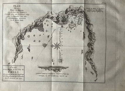
1756 Plan and Bay of Petaplan, Guerrero, Mexico by the English pirate Anson
Similar Sale History
View More Items in Maps & Atlases


![Acapulco'. Mexico. Town city plan. BELLIN / SCHLEY 1757: TITLE/CONTENT OF MAP: 'Acapulco [Acapulco]' This map is folding hence the centrefold line may show on the image below DATE PRINTED: 1757 IMAGE SIZE: Approx 24.0 x 34.5cm, 9.5 x 13.5 inches (Large); Pl](https://p1.liveauctioneers.com/5584/138985/70466044_1_x.jpg?height=310&quality=70&version=1554250661)


Related Maps & Atlases


More Items in Maps & Atlases
View More
![[Maps & Atlases] Oliva, Joan: Portolan Chart of the Mediterranean: [Maps & Atlases] Oliva, Joan: Portolan Chart of the Mediterranean Oliva, Joan Portolan Chart of the Mediterranean Marseille, 1615. Illuminated manuscript portolan chart on vellum, in red, blue, green,](https://p1.liveauctioneers.com/65/332523/179335172_1_x.jpg?height=310&quality=70&version=1717709445)


![Set of Twelve Satirical Anthropomorphic Maps of Europe: [SATIRICAL MAPS] A set of twelve satirical anthropomorphic maps of Europe. London: circa 1868. A set of 12 (believed complete) lithographed maps by Vincent Brooks, Day & Son, London, each offering](https://p1.liveauctioneers.com/292/330597/178279264_1_x.jpg?height=310&quality=70&version=1716409282)


![[Maps & Atlases] Speed, John: The Turkish Empire: [Maps & Atlases] Speed, John: The Turkish Empire Speed, John The Turkish Empire (London): Roger Rea the Elder and younger, 1626 (but, 1662 or after). Engraved hand-colored map, 16 3/4 x 21 1/2 in. (42](https://p1.liveauctioneers.com/65/332523/179335176_1_x.jpg?height=310&quality=70&version=1717709446)


Recommended Transportation & Travel Collectibles
View More


Item Details
Description
In 1756, the English pirate Anson produced a plan and depiction of the bay of Petaplan (also known as Petaplan), located in the Guerrero state of Mexico. Petaplan is situated in the Costa Grande region, positioned between Zihuatanejo and Acapulco. Anson's detailed portrayal offers a stunning view of the bay, capturing its features with remarkable precision. The map includes a compass, providing additional navigational context. Anson's account, titled "A Voyage Round the World," stands as one of the greatest firsthand chronicles of voyages, adventure, and piracy from the age of exploration. Published in London in 1756, the book recounts Anson's perilous mission to attack Spanish territories in western South America and seize Spanish treasure galleons. The endeavor was fraught with risks, as capture by the Spanish would have resulted in charges of piracy and the execution of Anson and his crew. Setting sail in 1740, Anson's squadron faced numerous hardships, losing over two-thirds of their crew and three of their eight ships during their arduous journey. However, their unwavering determination propelled them forward, and in 1744, with only 125 men remaining, they successfully completed a circumnavigation of the globe aboard their flagship, the Centurion. Anson's relentless efforts ultimately culminated in the capture of the formidable Spanish treasure galleon, 'Nuestra Señora de Cobadonga,' in 1743 off Cape Espiritu Santo on Samar Island in the Philippines. This triumph elevated Anson to the rank of Lord in the British crown, solidifying his reputation as one of the foremost English commanders during the Seven Years' War. The map of Petaplan is a copperplate engraving in excellent condition, measuring 21 1/4" x 11". Its authenticity is guaranteed.
Reserve: $100.00
Shipping:
Your purchase is protected:
Photos, descriptions, and estimates were prepared with the utmost care by a fully certified expert and appraiser. All items in this sale are guaranteed authentic.
In the rare event that the item did not conform to the lot description in the sale, Jasper52 specialists are here to help. Buyers may return the item for a full refund provided you notify Jasper52 within 5 days of receiving the item.
Condition
Excellent
Buyer's Premium
- 15%
1756 Plan and Bay of Petaplan, Guerrero, Mexico by the English pirate Anson
Estimate $120 - $150
Shipping & Pickup Options
Item located in New York, US$12 shipping in the US
Payment
Accepts seamless payments through LiveAuctioneers
See More Items From This Jasper52 Seller

Auction Curated By

Maps Expert
TOP