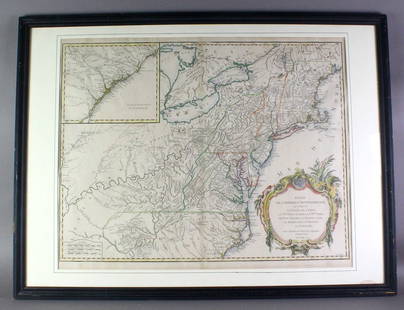
18th century. An original map of Belgium from the mid 1700s; Comte de Flandre attributed to Didier
Similar Sale History
View More Items in Maps & AtlasesRelated Maps & Atlases
More Items in Maps & Atlases
View MoreRecommended Transportation & Travel Collectibles
View More


Item Details
Description
18th century. An original map of Belgium from the mid 1700s; Comte de Flandre attributed to Didier Robert de Vaugondy (1732-1786) . Depicts the cities of Dunkirk, Lille, Bruges, and Alost; finished with a lovely cartouche at lower left corner. Overall good condition, toning toward edges; chipping on bottom edge. Measures 27 x 20 inches.
Buyer's Premium
- 25%
18th century. An original map of Belgium from the mid 1700s; Comte de Flandre attributed to Didier
Estimate $10 - $1,000
2 bidders are watching this item.
Shipping & Pickup Options
Item located in Cincinnati, OH, usOffers In-House Shipping
Local Pickup Available
Payment
Accepts seamless payments through LiveAuctioneers

Related Searches
TOP


![Mannevillette French Map of the Indian Ocean, 1753: D'APRES DE MANNEVILLETTE, Jean-Baptiste-Nicolas-Denis (1707-1780). [Indian Ocean] Carte Reduite de l'Ocean Oriental depuis le Cap de Bonne Esperance... Engraved map with original hand color in part. P](https://p1.liveauctioneers.com/1968/250616/130196497_1_x.jpg?height=310&quality=70&version=1654190895)


![Ptolemy / Waldseemuller Map of Sri Lanka or Taprobana, 1513 or 1520: PTOLEMY, Claudius (2nd Century) & WALDSEEMULLER, Martin (1470-1520). [Sri Lanka or Taprobana] Duodecima Asiae Tabula. Woodcut Map with original hand color. Strasbourg: Schott, 1513 or 1520. 17 1/2" x](https://p1.liveauctioneers.com/1968/250616/130196500_1_x.jpg?height=310&quality=70&version=1654190895)


![Antilles, Golfe du Mexique & Amérique Centrale. Caribbean. MALTE-BRUN c1871 map: TITLE/CONTENT OF MAP: Carte des Antilles, du Golfe du Mexique et des états de l'Amérique Centrale [Map of the West Indies, Gulf of Mexico and the states of Central America] DATE PRINTED: c18](https://p1.liveauctioneers.com/5584/327764/176591072_1_x.jpg?height=310&quality=70&version=1714507756)


