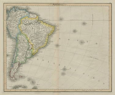
SOUTH AMERICA. Peru–Bolivian Confederacy. Gran Colombia. RAPKIN/TALLIS 1851 map
Similar Sale History
View More Items in Maps & Atlases


![South America (North). Brazil Colombia Peru &c. 50x60cm. JOHNSTON 1879 old map: Title: South America (North). Brazil Colombia Peru &c. 50x60cm. JOHNSTON 1879 old map Description: South America (Northern Sheet) [inset: Galapagos Isles]' by Alexander Keith Johnston (1879). Large, f](https://p1.liveauctioneers.com/5584/299901/159842120_1_x.jpg?height=310&quality=70&version=1693338270)


Related Maps & Atlases
More Items in Maps & Atlases
View MoreRecommended Transportation & Travel Collectibles
View More


Item Details
Description
This fascinating map shows Peru & Bolivia unified as the short-lived Peru–Bolivian Confederation, although this had ceased to exist some 12 years earlier in 1839. It also shows a united Gran Colombia, incorporating New Granada (today Colombia & Panama), Venezuela & Ecuador; however Gran Colombia had ceased to exist in 1831, when Ecuador & Venezuela had seceded. Uruguay is named as "Banda Oriental", Patagonia is shown as a separate state, with the balance of today's Argentina marked with its earlier name of "La Plata". New Granada (the United States of Colombia) incorporates Panama. Vignettes: Gold Washing in Brazil; Condor and Llamas in Peru; Brazilian Bridge of Ropes; Valparaiso; Descent of the Cordilleras; Natives of Chile; Rio de Janeiro
This fascinating map shows Peru & Bolivia unified as the short-lived Peru–Bolivian Confederation, although this had ceased to exist some 12 years earlier in 1839. It also shows a united Gran Colombia, incorporating New Granada (today Colombia & Panama), Venezuela & Ecuador; however Gran Colombia had ceased to exist in 1831, when Ecuador & Venezuela had seceded. Uruguay is named as "Banda Oriental", Patagonia is shown as a separate state, with the balance of today's Argentina marked with its earlier name of "La Plata". New Granada (the United States of Colombia) incorporates Panama. Vignettes: Gold Washing in Brazil; Condor and Llamas in Peru; Brazilian Bridge of Ropes; Valparaiso; Descent of the Cordilleras; Natives of Chile; Rio de Janeiro
DATE PRINTED: 1851
IMAGE SIZE: Approx 36.5 x 26.5cm, 14.5 x 10.25 inches (Large)
TYPE: Antique engraved map by J Rapkin, published by John Tallis. Original outline hand colour, decorative border, and attractive inset vignette views
CONDITION: Good; suitable for framing. However, please note: The image shown may have been taken from a different example of this map than that which is offered for sale. The map you will receive is in good condition but there may be minor variations in the condition from that shown in the image. This map was coloured by hand at the time of publication, thus the colouration may vary slightly between different examples of the map; the colouring applied to the map you receive may differ slightly from that shown in the image. Please check the scan for any blemishes prior to making your purchase. Virtually all antiquarian maps and prints are subject to some normal aging due to use and time which is not obtrusive unless otherwise stated. We offer a no questions asked return policy.
AUTHENTICITY: This is an authentic historic print, published at the date stated above. It is not a modern copy.
VERSO: There is nothing printed on the reverse side, which is plain
ARTIST/CARTOGRAPHER/ENGRAVER: Map drawn and engraved by J. Rapkin; vignette illustrations drawn by J Marchant & engraved by J Rogers. Published by John Tallis & Co
PROVENANCE: "Tallis's Illustrated Atlas and Modern History of the World, Geographical, Political, Commercial and Statistical", edited by R Montgomery Martin Esq., published by John Tallis and Company, London & New York [Tallis's Illustrated Atlas]
Reserve: $170.00
Shipping:
Your purchase is protected:
Photos, descriptions, and estimates were prepared with the utmost care by a fully certified expert and appraiser. All items in this sale are guaranteed authentic.
In the rare event that the item did not conform to the lot description in the sale, Jasper52 specialists are here to help. Buyers may return the item for a full refund provided you notify Jasper52 within 5 days of receiving the item.
Buyer's Premium
- 15%
SOUTH AMERICA. Peru–Bolivian Confederacy. Gran Colombia. RAPKIN/TALLIS 1851 map
Estimate $250 - $300
Shipping & Pickup Options
Item located in United KingdomOffers In-House Shipping
Payment
Accepts seamless payments through LiveAuctioneers
See More Items From This Jasper52 Seller

TOP


![d'Anville (Jean Baptiste Bourguignon) [Untitled Composite Atlas with 102 map sheets], [probably: d'Anville (Jean Baptiste Bourguignon) [Untitled Composite Atlas with 102 map sheets], comprising 20 double-page maps, 9 two-sheet double-page maps, 3 two-sheet maps on folding double-pages [Asia, Afri](https://p1.liveauctioneers.com/5458/329231/177514974_1_x.jpg?height=310&quality=70&version=1715269091)


![South-west Europe. Swiss Savoy. British Hanover. THOMSON 1817 old antique map: TITLE/CONTENT OF MAP: [South-west sheet of] A map of Europe, with the political divisions after the Peace of Paris and Congress of Vienna The map shows south west Europe after the Congress of Vienna.](https://p1.liveauctioneers.com/5584/328641/177014448_1_x.jpg?height=310&quality=70&version=1715113718)


![[Maps] Gio. Ant. Magnini, Italia, 1620: [Maps] Gio. Ant. Magnini, Italia, 1620, Giovanni Antonio Magnini. Italia, data in luce da Fabio suo figliuolo al Serenissimo Ferdinado Gonzaga Duca di Matoua edi Monserrato etc. Bologna, for Sebastian](https://p1.liveauctioneers.com/188/326797/176317457_1_x.jpg?height=310&quality=70&version=1713847031)
![[Maps] Martin Zeiler, Itinerarium Italiae, 1640: [Maps] Martin Zeiler, Itinerarium Italiae, 1640, Martini Zeilleri. Itinerarium Italiae Nov-Antiquae: oder, Raiss-Beschreibung durch Italien, Matthaus Merian, Frankfurt, 40 plates, most double-page, in](https://p1.liveauctioneers.com/188/326797/176317459_1_x.jpg?height=310&quality=70&version=1713847031)


![[MAP]. TODESCHI, Pietro. [Nova et Acurata Totius Americae Tabula auct. G.I. Blaeu] America quarta: [MAP]. TODESCHI, Pietro. [Nova et Acurata Totius Americae Tabula auct. G.I. Blaeu] America quarta pars orbis quam plerunq, nuvum orbem appellitant primo detecta est anno 1492 a Christophoro Columbo...](https://p1.liveauctioneers.com/197/329395/177650542_1_x.jpg?height=310&quality=70&version=1715364962)


