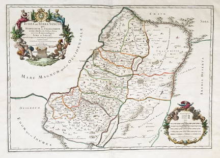
Antique Map of the Holy Land
Similar Sale History
View More Items in Maps & AtlasesRelated Maps & Atlases
More Items in Maps & Atlases
View MoreRecommended Transportation & Travel Collectibles
View More


Item Details
Description
La Judee ou Terre Sainte, divisee en ses douze Tribus, map of the Holy Land printed in 1779. Engraved hand painted map, with French captions. Was printed in: Robert de Vaugondy, Gilles and Didier, Atlas Universal, by Santini, Venice, 1779. 47.5X60 cm. Overall good condition.
Buyer's Premium
- 30%
Antique Map of the Holy Land
Estimate $150 - $250
2 bidders are watching this item.
Shipping & Pickup Options
Item located in Tel Aviv, Israel, ilOffers In-House Shipping
Local Pickup Available
Payment

Related Searches
TOP


![Antique Map of The Holy Land, Dated 1792: "Generaale Kaart Van Het Beloofde Land" colored map of The Holy Land, covering present-day Israel and Palestine, bordered by Egypt and Syria. Dated 1792, unframed. [22 x 26 inches]. Dry, losses, creas](https://p1.liveauctioneers.com/1221/303742/163342134_1_x.jpg?height=310&quality=70&version=1697564518)


![Battle of Coronel, November 1st 1914. First World War. 1920 old antique map: CAPTION PRINTED BELOW PICTURE: Coronel November 1st 1914 [Battle of Coronel] DATE PRINTED: 1920 IMAGE SIZE: Approx 68.0 x 55.5cm, 26.75 x 21.75 inches (Large); Please note that this is a folding map.](https://p1.liveauctioneers.com/5584/326888/175994716_1_x.jpg?height=310&quality=70&version=1713903186)


