


 Discovery- InteriorsBonhamsSponsored.Your ad here?
Discovery- Interiors
Bonhams
Sponsored.Your ad here?


Discovery- InteriorsBonhamsSponsored.Your ad here?
Discovery- Interiors
Bonhams
Sponsored.Your ad here?

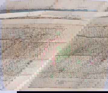
Collection of Allied Military Silk Printed Maps, WWII Era and Later
Similar Sale History
View More Items in Maps & Atlases


Related Maps & Atlases


More Items in Maps & Atlases
View More


![[Maps] Martin Zeiler, Itinerarium Italiae, 1640: [Maps] Martin Zeiler, Itinerarium Italiae, 1640, Martini Zeilleri. Itinerarium Italiae Nov-Antiquae: oder, Raiss-Beschreibung durch Italien, Matthaus Merian, Frankfurt, 40 plates, most double-page, in](https://p1.liveauctioneers.com/188/326797/176317459_1_x.jpg?height=310&quality=70&version=1713847031)


![[Maps] Gio. Ant. Magnini, Italia, 1620: [Maps] Gio. Ant. Magnini, Italia, 1620, Giovanni Antonio Magnini. Italia, data in luce da Fabio suo figliuolo al Serenissimo Ferdinado Gonzaga Duca di Matoua edi Monserrato etc. Bologna, for Sebastian](https://p1.liveauctioneers.com/188/326797/176317457_1_x.jpg?height=310&quality=70&version=1713847031)


Recommended Transportation & Travel Collectibles
View More


Item Details
Description
Collection of Allied Military Silk Printed Maps, WWII Era and Later. These maps were employed during World War II and beyond to aid Allied soldiers in escaping enemy territory or POW camps, helping them navigate and return to their regiments. Designed to be water-resistant, crease-resistant, easily hidden, and manipulated without producing noise, these maps were a crucial tool for covert operations. Soldiers could fold and conceal them in various ingenious ways, such as in boot heels, jacket linings, and remarkably, within Monopoly game boards, ensuring their undetected use in critical situations. Size: ranging from 18'' x 13'', 46 x 33 cm to 34'' x 28.5'', 86 x 72 cm. Provenance: Ex Yosi Barzilai collection.
Condition
This is a NO RESERVE AUCTION: there are no hidden or confidential reserves, all acceptable bidding commences at the online START PRICE. Please let us know if you would like to receive a condition report or have any specific questions regarding the condition of a lot. Condition reports will be sent during the week prior to the auction, and can be requested via email (lot inquiry button) or by telephone: 215-438-4700. Absence of a statement to condition in the description does not construe a statement of any kind. Please refer to Terms and Conditions of the sale.
Buyer's Premium
- 30%
Collection of Allied Military Silk Printed Maps, WWII Era and Later
Estimate $300 - $600
8 bidders are watching this item.
Shipping & Pickup Options
Item located in Philadelphia, PA, usSee Policy for Shipping
Local Pickup Available
Payment
Accepts seamless payments through LiveAuctioneers

TOP