


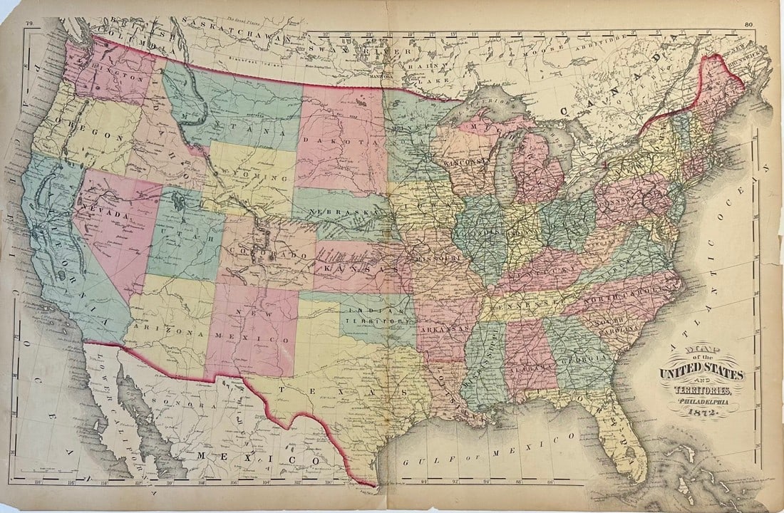
1872 Map of United States & Territories
Similar Sale History
View More Items in Maps & Atlases


![Five Antique Maps of the Western United States: [Five Antique Maps of the Western United States], incl. "Map of the United States Territory of Oregon...", by Hood, 1838; "Johnson's California, with Utah...", Johnson and Ward, 1864; "Map Showing the](https://p1.liveauctioneers.com/268/141383/71622474_1_x.jpg?height=310&quality=70&version=1556895875)


Related Maps & Atlases


![South-west & Central Europe. Switzerland includes Haute-Savoie. THOMSON 1830 map: TITLE/CONTENT OF MAP: [Europe after the Congress of Vienna - South-west sheet] An oddly-misshapen Switzerland erroneously includes what is now the French departement of Haute Savoie and part of Savoie](https://p1.liveauctioneers.com/5584/328641/177014316_1_x.jpg?height=310&quality=70&version=1715113718)
![South-west Europe. Swiss Savoy. British Hanover. THOMSON 1817 old antique map: TITLE/CONTENT OF MAP: [South-west sheet of] A map of Europe, with the political divisions after the Peace of Paris and Congress of Vienna The map shows south west Europe after the Congress of Vienna.](https://p1.liveauctioneers.com/5584/328641/177014448_1_x.jpg?height=310&quality=70&version=1715113718)
![South-west & Central Europe. Switzerland includes Haute-Savoie. THOMSON 1817 map: CAPTION PRINTED BELOW PICTURE: [Europe after the Congress of Vienna - South-west sheet] An oddly-misshapen Switzerland erroneously includes what is now the French departement of Haute Savoie and part](https://p1.liveauctioneers.com/5584/328641/177014438_1_x.jpg?height=310&quality=70&version=1715113718)
![Europe after the Congress of Vienna. 4 sheets. 128x106cm. THOMSON 1817 old map: TITLE/CONTENT OF MAP: A map of Europe, with the political divisions after the Peace of Paris and Congress of Vienna [4 sheets] This very large map, printed on 4 sheets, shows a re-aligned Europe after](https://p1.liveauctioneers.com/5584/328641/177014440_1_x.jpg?height=310&quality=70&version=1715113718)


More Items in Maps & Atlases
View More


![[Maps] Gio. Ant. Magnini, Italia, 1620: [Maps] Gio. Ant. Magnini, Italia, 1620, Giovanni Antonio Magnini. Italia, data in luce da Fabio suo figliuolo al Serenissimo Ferdinado Gonzaga Duca di Matoua edi Monserrato etc. Bologna, for Sebastian](https://p1.liveauctioneers.com/188/326797/176317457_1_x.jpg?height=310&quality=70&version=1713847031)
![[Maps] Martin Zeiler, Itinerarium Italiae, 1640: [Maps] Martin Zeiler, Itinerarium Italiae, 1640, Martini Zeilleri. Itinerarium Italiae Nov-Antiquae: oder, Raiss-Beschreibung durch Italien, Matthaus Merian, Frankfurt, 40 plates, most double-page, in](https://p1.liveauctioneers.com/188/326797/176317459_1_x.jpg?height=310&quality=70&version=1713847031)


Recommended Transportation & Travel Collectibles
View More


Item Details
Description
This original geological map of the United States and Territories was published in the 1872 "New Topographical Atlas of the State of Pennsylvania with Descriptions Historical, Scientific, and Statistical," by Walling and Gray. This map shows states, major cities, some topography, forts, railroads, and some native tribes. A small area in the Rocky Mountains between Montana, Wyoming, and Idaho is labeled Part of Dakota.
Reserve: $95.00
Shipping:
Your purchase is protected:
Photos, descriptions, and estimates were prepared with the utmost care by a fully certified expert and appraiser. All items in this sale are guaranteed authentic.
In the rare event that the item did not conform to the lot description in the sale, Jasper52 specialists are here to help. Buyers may return the item for a full refund provided you notify Jasper52 within 5 days of receiving the item.
Condition
Very Good
Buyer's Premium
- 15%
1872 Map of United States & Territories
Estimate $110 - $150
Get approved to bid.
Shipping & Pickup Options
Item located in Delaware, US$25 shipping in the US
Payment
Accepts seamless payments through LiveAuctioneers
See More Items From This Jasper52 Seller

TOP