


ANNOTATED WORLD WAR II GERMAN LUFTWAFFE NAVIGATION MAP
Similar Sale History
View More Items in Maps & Atlases


Related Maps & Atlases


More Items in Maps & Atlases
View More


Recommended Transportation & Travel Collectibles
View More


Item Details
Description
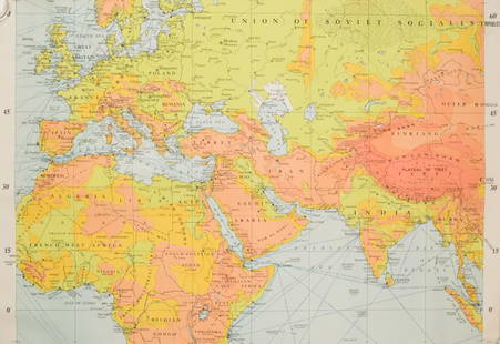
An excellent map of Europe, undated and 48 in. square, showing red and blue indelible pencil flight routes and landing points over the whole continent, from eastern Germany to the Normandy coast. Drop points are concentrated along Normandy and south of Augsburg, leading one to speculate about when this map was notated, perhaps 1942, and also to speculate as to why most of the flight paths are in red while a much fewer number are in blue. Linen-backed for easy folding and portability, and in very good condition.
Buyer's Premium
- 30%
ANNOTATED WORLD WAR II GERMAN LUFTWAFFE NAVIGATION MAP
Estimate $300 - $400
4 bidders are watching this item.
Shipping & Pickup Options
Item located in Chesapeake City, MD, usOffers In-House Shipping
Local Pickup Available
Payment

TOP