


Item Details
Description
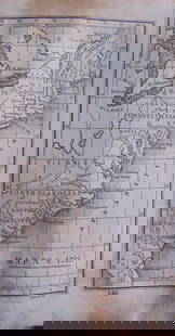
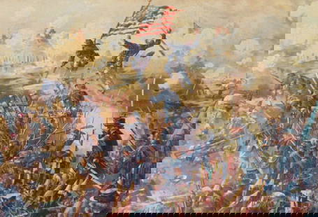
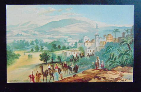
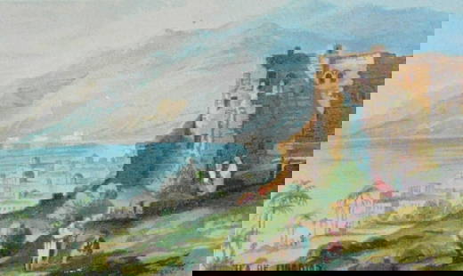
Map Exhibiting the 1620 land grants made by the King of Great Britain and France during the early part of the 17th century
Map No. 3.
Cartographer: Roberts
Dated: Circa 1840
Dimensions: 6 x 4"
Condition Report Toning. Rounded left tips. Good
Subject References: 220
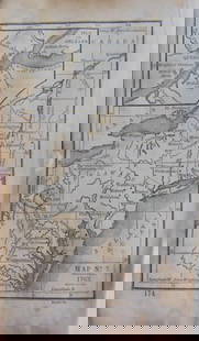
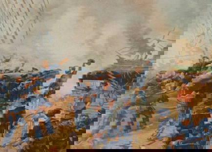
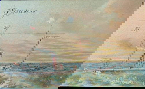
Map No. 3.
Cartographer: Roberts
Dated: Circa 1840
Dimensions: 6 x 4"
Condition Report Toning. Rounded left tips. Good
Subject References: 220
Buyer's Premium
- 25%
Map 1620 English & French American Land Grants
Estimate $200 - $300
Starting Price
$100
or 4 payments of $25.00 with 
Get approved to bid.
Shipping & Pickup Options
Item located in Otisville, NY, USOffers In-House Shipping
Payment
Accepts seamless payments through LiveAuctioneers
Auctioneer Announcement
American Prints on Memorial Day

Spring Hudson Valley Estates Auction
Otisville, NY, USA


Related Maps & Atlases


![French Map of America Southwest & Mexico [179298]: French map the American Southwest and Mexico. This is a double truck from an 18th century book and measures 10x 14". Map from 1787 during the reign of Louie XVI the king France who beheaded in1793.Riv](https://p1.liveauctioneers.com/2699/331495/178785763_1_x.jpg?height=310&quality=70&version=1717094933)

![Early French Map of Great Lakes [179300]: Early French (circa 1780s) map of the Great Lakes region and parts of Canada. Map, a double truck page from a book, measures 9"x 13" and shows the various Indian tribes in the area, including the Algo](https://p1.liveauctioneers.com/2699/331495/178785744_1_x.jpg?height=310&quality=70&version=1717094933)
![French Map of America Southeast [179304]: Northeastern American map published 1788 from a French cartographer. Map measures 9"x 13". Published during America's War of Independence from Great Britain (1176-1783), this map features the mid-Atla](https://p1.liveauctioneers.com/2699/331495/178785746_1_x.jpg?height=310&quality=70&version=1717094933)
![Early French Map of East Coast & Canada [179301]: This is a circa 1790 French map of the Eastern Seaboard of America and parts of Canada. Landmarks and waterways are clearly marked as are the territories inhabited by Indian tribes, including the Iroq](https://p1.liveauctioneers.com/2699/331495/178785745_1_x.jpg?height=310&quality=70&version=1717094933)
![Maps of Spain, France, & Portugal, c1800s (3) [180172]: (3) Maps of Spain, Portugal, and France. 1. "Map of Spain, Portugal and France" with inset of Island of Corsica and Switzerland. Detailed and colorful map with floral border. S. Augustus Mitchell Jr.](https://p1.liveauctioneers.com/2699/331495/178785790_1_x.jpg?height=310&quality=70&version=1717094933)


More Items in Maps & Atlases
View More![[MAPS]. HOMANN, Johann Baptist, HOMANN HEIRS, and Georg Matthäus SEUTTER. [Composite Atlas].: [MAPS]. HOMANN, Johann Baptist (1663-1724), HOMANN HEIRS, and Georg Matthäus SEUTTER (1678-1757). [Composite Atlas]. [Nuremberg, Augsburg, and others: Homann Heirs and others, maps dated between](https://p1.liveauctioneers.com/197/329395/177650530_1_x.jpg?height=310&quality=70&version=1715364962)
![[MAP]. TODESCHI, Pietro. [Nova et Acurata Totius Americae Tabula auct. G.I. Blaeu] America quarta: [MAP]. TODESCHI, Pietro. [Nova et Acurata Totius Americae Tabula auct. G.I. Blaeu] America quarta pars orbis quam plerunq, nuvum orbem appellitant primo detecta est anno 1492 a Christophoro Columbo...](https://p1.liveauctioneers.com/197/329395/177650542_1_x.jpg?height=310&quality=70&version=1715364962)

![[MAP]. ORTELIUS, Abraham. Americae Sive Novi Orbis, Nova Descriptio. 1573.: [MAP]. ORTELIUS, Abraham (1527-1598). Americae Sive Novi Orbis, Nova Descriptio. Antwerp, 1573. Engraved map with hand-coloring. Framed and double glazed, visible area 375 x 521 mm (unexamined out of](https://p1.liveauctioneers.com/197/329395/177650534_1_x.jpg?height=310&quality=70&version=1715364962)

![[MAP]. ORTELIUS, Abraham. Turcici Imperii Descriptio.1592.: [MAP]. ORTELIUS, Abraham (1527-1598). Turcici Imperii Descriptio. Antwerp, 1592. Engraved map with hand-coloring. Matted, framed, and double glazed, sight 406 x 521 mm (unexamined out of frame). Decor](https://p1.liveauctioneers.com/197/329395/177650538_1_x.jpg?height=310&quality=70&version=1715364962)
![[MAP]. SPEED, John. A New Mappe of the Romane Empire. 1676.: [MAP]. SPEED, John (ca 1551-1629). A New Mappe of the Romane Empire. London: Basset & Chiswell, 1676. Engraved map with hand-coloring. Framed and double glazed, sight 419 x 559 mm. Decorative cartouch](https://p1.liveauctioneers.com/197/329395/177650541_1_x.jpg?height=310&quality=70&version=1715364962)
![Set of Twelve Satirical Anthropomorphic Maps of Europe: [SATIRICAL MAPS] A set of twelve satirical anthropomorphic maps of Europe. London: circa 1868. A set of 12 (believed complete) lithographed maps by Vincent Brooks, Day & Son, London, each offering](https://p1.liveauctioneers.com/292/330597/178279264_1_x.jpg?height=310&quality=70&version=1716409282)


![[MAP]. ORTELIUS, Abraham. Romani Imperii Imago. 1592.: [MAP]. ORTELIUS, Abraham (1527-1598). Romani Imperii Imago. Antwerp, 1592. Engraved map with hand-coloring. Matted, framed, and double glazed, visible area 381 x 521 mm (unexamined out of frame). 6 de](https://p1.liveauctioneers.com/197/329395/177650537_1_x.jpg?height=310&quality=70&version=1715364962)

![[MAP]. ORTELIUS, Abraham. Aevi Veteris, Typus Geographicus. 1601.: [MAP]. ORTELIUS, Abraham (1527-1598). Aevi Veteris, Typus Geographicus. Antwerp, 1601. Engraved map with hand-coloring. Matted, framed, and double glazed, visible area 343 x 470 mm (unexamined out of](https://p1.liveauctioneers.com/197/329395/177650532_1_x.jpg?height=310&quality=70&version=1715364962)
Recommended Transportation & Travel Collectibles
View More


Related Searches
TOP